109.133.79.169 - IP Lookup: Free IP Address Lookup, Postal Code Lookup, IP Location Lookup, IP ASN, Public IP
Country:
Region:
City:
Location:
Time Zone:
Postal Code:
IP information under different IP Channel
ip-api
Country
Region
City
ASN
Time Zone
ISP
Blacklist
Proxy
Latitude
Longitude
Postal
Route
Luminati
Country
Region
vlg
City
ghent
ASN
Time Zone
Europe/Brussels
ISP
Proximus NV
Latitude
Longitude
Postal
IPinfo
Country
Region
City
ASN
Time Zone
ISP
Blacklist
Proxy
Latitude
Longitude
Postal
Route
IP2Location
109.133.79.169Country
Region
oost-vlaanderen
City
gent
Time Zone
Europe/Brussels
ISP
Language
User-Agent
Latitude
Longitude
Postal
db-ip
Country
Region
City
ASN
Time Zone
ISP
Blacklist
Proxy
Latitude
Longitude
Postal
Route
ipdata
Country
Region
City
ASN
Time Zone
ISP
Blacklist
Proxy
Latitude
Longitude
Postal
Route
Popular places and events near this IP address

Saint Nicholas Church, Ghent
Church in Ghent, Belgium
Distance: Approx. 614 meters
Latitude and longitude: 51.054,3.7229
St. Nicholas Church (Dutch: Sint-Niklaaskerk) is a Roman Catholic church, as well as one of the oldest and most prominent landmarks in Ghent, Belgium. Begun in the early 13th century as a replacement for an earlier Romanesque church, construction continued through the rest of the century in the local Scheldt Gothic style (named after the nearby river).
Trams in Ghent
Distance: Approx. 397 meters
Latitude and longitude: 51.053,3.72
The Ghent tramway network (Dutch: de Gentse tram) is a network of tramways forming part of the public transport system in Ghent, a city in the Flemish Region of Belgium, with a total of four lines (T1, T2, T3 and T4). Since 1991, the network has been operated by De Lijn, the public transport entity responsible for buses and trams in Flanders. The network is being operated with HermeLijn trams and Bombardier Flexity 2 trams.

Saint Michael's Church, Ghent
Distance: Approx. 427 meters
Latitude and longitude: 51.05361111,3.71916667
Saint Michael's Church (Dutch: Sint-Michielskerk) is a Roman Catholic church in Ghent, Belgium, built in a late Gothic style. It is known for its rich interior decoration.

Fall of Ghent
1745 siege
Distance: Approx. 11 meters
Latitude and longitude: 51.05,3.71666694
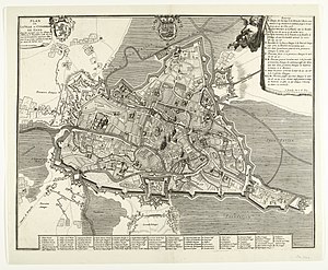
The Fall of Ghent occurred on 15 July 1745 during the War of the Austrian Succession when a 5,000 strong French force under Ulrich Frédéric Woldemar, Comte de Lowendal surprised and captured the town of Ghent in the Austrian Netherlands. The Allied garrison offered little resistance. Coming in the wake of the Battle of Fontenoy, the loss of Ghent proved a shock to the Allies.
Sint-Barbaracollege
School in Ghent, Belgium
Distance: Approx. 562 meters
Latitude and longitude: 51.048767,3.724446
Sint-Barbaracollege in Ghent, Belgium, is a public Jesuit school, founded in 1833. It currently includes primary and secondary education.

Design Museum Gent
Museum in Ghent, Belgium
Distance: Approx. 682 meters
Latitude and longitude: 51.055833,3.720139
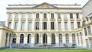
Design Museum Gent is a museum in Belgium with an international design collection. The museum complex is located in the tourist centre of Ghent and comprises an 18th-century mansion and a modern wing. The museum holds a collection of Belgian design, supported by international objects.

Graslei
Distance: Approx. 617 meters
Latitude and longitude: 51.055,3.72083333
Graslei (Dutch pronunciation: [ˈɣrɑslɛi]; English: Grass Quay) is a quay in the historic city center of Ghent, Belgium, located on the right bank of the Leie river. The quay opposite of the Graslei is called Korenlei. Both quays were part of the medieval port and are now a cultural and touristic hotspot of the city, with a high concentration of café patios.
Korenlei
Distance: Approx. 617 meters
Latitude and longitude: 51.055,3.72083333
Korenlei (Dutch pronunciation: [ˈkoːrə(n)lɛi]; English: Wheat Quay or Corn Quay) is a quay in the historic city center of Ghent, Belgium, located on the left bank of the Leie river. The quay on the opposite bank of the Leie is Graslei.
Korenmarkt, Ghent
Square in Ghent, Belgium
Distance: Approx. 607 meters
Latitude and longitude: 51.05444444,3.72194444
The Korenmarkt (Dutch pronunciation: [ˈkoːrəmɑr(ə)kt]; "Wheat Market") is a city square in the historic centre of Ghent, East Flanders, Belgium. Located between the Leie river and St. Nicholas' Church, it is one of the city's most important and famous tourist locations.

Stadshal, Ghent
Large stand-alone canopy in Ghent, Belgium
Distance: Approx. 706 meters
Latitude and longitude: 51.05416667,3.72444444
The Stadshal (English: City Pavilion) is a large stand-alone canopy in the inner city of Ghent, Belgium. The construction was part of the city project to redevelop the squares and public spaces in Ghent's historic city centre. The Stadshal, located on the square between the Belfry, the Renaissance Town Hall and St.

Hotel d'Hane-Steenhuyse
Grand townhouse in Belgium
Distance: Approx. 390 meters
Latitude and longitude: 51.05164,3.7217
The Hotel d'Hane-Steenhuyse is an 18th-century hôtel particulier (grand townhouse) in the Belgian city of Ghent. It is located in the Veldstraat and was formerly owned by the D'Hane de Steenhuyse family.

Siege of Ghent (1708)
Distance: Approx. 11 meters
Latitude and longitude: 51.05,3.71666694
The siege of Ghent (18–30 December 1708) was the last operation of the 1708 campaign season during the War of the Spanish Succession. After successfully taking Lille shortly before, the Duke of Marlborough moved his forces onto the town of Ghent where after a 12-day siege the town's governor, Count Charles de La Mothe-Houdancourt, surrendered.
Weather in this IP's area
broken clouds
7 Celsius
7 Celsius
7 Celsius
8 Celsius
1036 hPa
79 %
1036 hPa
1034 hPa
10000 meters
1.57 m/s
1.81 m/s
63 degree
83 %


