109.107.115.135 - IP Lookup: Free IP Address Lookup, Postal Code Lookup, IP Location Lookup, IP ASN, Public IP
Country:
 Spain
SpainRegion:
City:
Location:
Time Zone:
Postal Code:
ISP:
ASN:
language:
User-Agent:
Proxy IP:
Blacklist:
IP information under different IP Channel
ip-api
Country
Region
City
ASN
Time Zone
ISP
Blacklist
Proxy
Latitude
Longitude
Postal
Route
db-ip
Country
Region
City
ASN
Time Zone
ISP
Blacklist
Proxy
Latitude
Longitude
Postal
Route
IPinfo
Country
Region
City
ASN
Time Zone
ISP
Blacklist
Proxy
Latitude
Longitude
Postal
Route
IP2Location
109.107.115.135Country
esRegion
galicia
City
o carballino
Time Zone
Europe/Madrid
ISP
Language
User-Agent
Latitude
Longitude
Postal
ipdata
Country
Region
City
ASN
Time Zone
ISP
Blacklist
Proxy
Latitude
Longitude
Postal
Route
Popular places and events near this IP address
Leiro
Municipality in Galicia, Spain
Distance: Approx. 7901 meters
Latitude and longitude: 42.36916667,-8.12472222
Leiro is a municipality in the province of Ourense, in the autonomous community of Galicia, Spain. It belongs to the comarca of O Ribeiro.

Boborás
Municipality in Galicia, Spain
Distance: Approx. 5837 meters
Latitude and longitude: 42.43333333,-8.15
Boborás is a municipality in the province of Ourense, in the autonomous community of Galicia, Spain. It belongs to the comarca of O Carballiño.
Maside
Municipality in Galicia, Spain
Distance: Approx. 4956 meters
Latitude and longitude: 42.41305556,-8.02416667
Maside is a municipality in the province of Ourense, in the autonomous community of Galicia, Spain. It belongs to the comarca of O Carballiño.

Punxín
Municipality in Galicia, Spain
Distance: Approx. 8774 meters
Latitude and longitude: 42.37027778,-8.01194444
Punxín is a municipality in the province of Ourense, in the autonomous community Galicia, Spain. It belongs to the comarca of O Carballiño.

San Amaro
Municipality in Galicia, Spain
Distance: Approx. 6535 meters
Latitude and longitude: 42.37305556,-8.07305556
San Amaro is a municipality in the province of Ourense, in the autonomous community of Galicia, Spain. It belongs to the comarca of O Carballiño. Its name is a homage to Saint Amaro.
San Cristovo de Cea
Municipality in Galicia, Spain
Distance: Approx. 9180 meters
Latitude and longitude: 42.4725,-7.98194444
San Cristovo de Cea is a municipality in the province of Ourense, in the autonomous community of Galicia, Spain. It belongs to the comarca of O Carballiño.

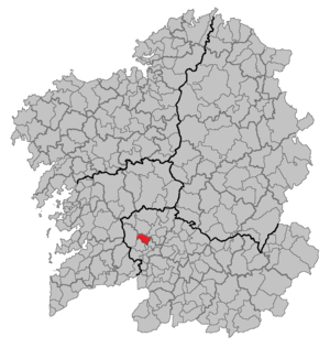
O Carballiño (comarca)
Comarca in Galicia, Spain
Distance: Approx. 2110 meters
Latitude and longitude: 42.43777778,-8.05472222
O Carballiño is a comarca in the Galician Province of Ourense. The overall population of this local region is 26,549 (2019).

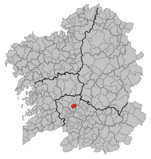
O Carballiño
Municipality in Galicia, Spain
Distance: Approx. 117 meters
Latitude and longitude: 42.43055556,-8.07916667
O Carballiño is a municipality in the province of Ourense, in the autonomous community of Galicia, Spain. It has a population of 13,939 (2019) and an area of 54 km2.

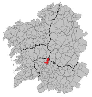
CD Arenteiro
Association football club in Spain
Distance: Approx. 931 meters
Latitude and longitude: 42.424862,-8.085704
Club Deportivo Arenteiro is a football team based in O Carballiño in the autonomous community of Galicia. Founded in 1958, it plays in Primera Federación – Group 1. Its stadium is Espiñedo with a capacity of 4,500 seats.

Arenteiro
Distance: Approx. 6580 meters
Latitude and longitude: 42.39668056,-8.1436
The Arenteiro is a river in Galicia, in Spain.

Galician Massif
Distance: Approx. 7807 meters
Latitude and longitude: 42.5,-8.1
The Galician Massif or Galician-Leonese Massif (Spanish: Macizo Galaico, also known as Macizo Galaico-Leonés) is a system of mountain ranges in the northwestern corner of the Iberian Peninsula. It is located in Galicia with its southeastern end reaching into the provinces of Zamora and León of Castile and León. Its highest point is Pena Trevinca at 2,127 metres (6,978 ft) .

Castro of San Cibrao de Las
Archeological site in Galicia, Spain
Distance: Approx. 8921 meters
Latitude and longitude: 42.3601,-8.03
San Cibrao de Las hill fort (Castro de San Cibrao de Las) is an archeological site in Galicia, Spain. It is a hill fort of the so-called castro culture. Rather than a single castle, it encompasses an entire fortified town or village.
Weather in this IP's area
overcast clouds
6 Celsius
5 Celsius
6 Celsius
6 Celsius
1018 hPa
96 %
1018 hPa
956 hPa
10000 meters
2.04 m/s
5.76 m/s
2 degree
100 %