Country:
 Romania
Region:
City:
Latitude and Longitude:
Time Zone:
Postal Code:
IP information under different IP Channel
ip-api
Country
Region
City
ASN
Time Zone
ISP
Blacklist
Proxy
Latitude
Longitude
Postal
Route
IPinfo
Country
Region
City
ASN
Time Zone
ISP
Blacklist
Proxy
Latitude
Longitude
Postal
Route
MaxMind
Country
Region
City
ASN
Time Zone
ISP
Blacklist
Proxy
Latitude
Longitude
Postal
Route
Luminati
Country
RORegion
b
City
bucharest
ASN
Time Zone
Europe/Bucharest
ISP
Orange Romania S.A.
Latitude
Longitude
Postal
db-ip
Country
Region
City
ASN
Time Zone
ISP
Blacklist
Proxy
Latitude
Longitude
Postal
Route
ipdata
Country
Region
City
ASN
Time Zone
ISP
Blacklist
Proxy
Latitude
Longitude
Postal
Route
Popular places and events near this IP address

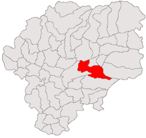
Bistrița-Năsăud County
County of Romania
Distance: Approx. 991 meters
Latitude and longitude: 47.1389,24.5003
Bistrița-Năsăud (Romanian pronunciation: [ˈbistrit͡sa nəsəˈud] ) is a county (județ) of Romania, in Transylvania, with its capital city at Bistrița.
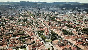
Bistrița
Municipality in Bistrița-Năsăud, Romania
Distance: Approx. 456 meters
Latitude and longitude: 47.13333333,24.5
Bistrița (Romanian pronunciation: [ˈbistrit͡sa] ; ‹See Tfd›German: Bistritz, archaic Nösen, Transylvanian Saxon: Bästerts, Hungarian: Beszterce) is the capital city of Bistrița-Năsăud County, in northern Transylvania, Romania. It is situated on the Bistrița River. The city has a population of 78,877 inhabitants as of 2021 and administers six villages: Ghinda (Windau; Vinda), Sărata (Salz; Sófalva), Sigmir (Schönbirk; Szépnyír), Slătinița (Pintak; Pinták), Unirea (until 1950 Aldorf; Wallendorf; Aldorf) and Viișoara (Heidendorf; Besenyő).

Beszterce-Naszód County
County of the Kingdom of Hungary
Distance: Approx. 456 meters
Latitude and longitude: 47.13333333,24.5
Beszterce-Naszód was an administrative county (comitatus) of the Kingdom of Hungary. Its territory is now in northern Romania (north-eastern Transylvania). The capital of the county was Beszterce (now Bistrița).

Budușel
River in Bistrița-Năsăud County, Romania
Distance: Approx. 7027 meters
Latitude and longitude: 47.1069,24.5903
The Budușel is a right tributary of the river Budac in Romania. It flows into the Budac near Orheiu Bistriţei. Its length is 17 km (11 mi) and its basin size is 68 km2 (26 sq mi).
Livezile, Bistrița-Năsăud
Commune in Bistrița-Năsăud, Romania
Distance: Approx. 7470 meters
Latitude and longitude: 47.17972222,24.57111111
Livezile (until 1960 Iad; Hungarian: Jád; ‹See Tfd›German: Jaad) is a commune located in Bistrița-Năsăud County, Transylvania, Romania. It is composed of five villages: Cușma (Kusma), Dorolea (Aszúbeszterce), Dumbrava (Dumbráva), Livezile and Valea Poenii (Bureaka).

Budacu de Jos
Commune in Bistrița-Năsăud, Romania
Distance: Approx. 5324 meters
Latitude and longitude: 47.08333333,24.51666667
Budacu de Jos (‹See Tfd›German: Deutsch-Budak; Hungarian: Szászbudak) is a commune in Bistrița-Năsăud County, Transylvania, Romania. It is composed of five villages: Budacu de Jos, Buduș (Alsóbudak;Budesdorf), Jelna (Kiszsolna; Senndorf), Monariu (Malomárka; Minarken), and Simionești (Simontelke; Seimersdorf).

Jean Pădureanu Stadium
Distance: Approx. 118 meters
Latitude and longitude: 47.13083333,24.50277778
The Jean Pădureanu Stadium is a multi-purpose stadium in Bistrița, Romania. It is currently used mostly for football matches and is the home ground of Gloria Bistrița-Năsăud, considered the unofficial successor of ACF Gloria Bistrița. The stadium is named after the former president of Gloria Bistrița, Jean Pădureanu.
Castra of Livezile
Fort in the Roman province of Dacia
Distance: Approx. 6218 meters
Latitude and longitude: 47.16666667,24.56666667
The castra of Livezile was a castra in the Roman province of Dacia, located in the north side of the modern commune of Livezile in the historical region of Transylvania, Romania. The fort was erected and surrounded by a ditch in the 2nd century AD. The castra was abandoned in the 3rd century and its ruins are still visible.
Dacian fortress of Monariu
Distance: Approx. 6933 meters
Latitude and longitude: 47.0755,24.461
The so called Monariu Dacian fortress is the name of the ruined remnants of a Dacian fortified town in Cetate and Monariu, both in Bistrița-Năsăud County, in northern Romania. The actual historical name of the ruined settlement is unknown.

Liviu Rebreanu National College
Distance: Approx. 839 meters
Latitude and longitude: 47.1348,24.4952
Liviu Rebreanu National College (Romanian: Colegiul Național "Liviu Rebreanu") is a public day college in Bistrița, Romania, located at 8 Republicii Boulevard. The school building, which dates to the Austro-Hungarian period, initially housed the Lutheran Gymnasium, and was used by the city's German-speaking Transylvanian Saxon population. Preparation began in 1900, when the old school was sold and the revenue used to purchase a lot.

TeraPlast Arena
Indoor arena in Bistrița, Romania
Distance: Approx. 5429 meters
Latitude and longitude: 47.1621,24.5587
TeraPlast Arena is a multi-purpose arena located in the Wonderland complex in Unirea neighbourhood of Bistrița, Romania. It is the home of Gloria Bistrița of the Liga Florilor MOL. Groundbreaking and construction began on 18 October 2019. The arena opened on 12 August 2022.

Entry of the Theotokos into the Temple Church, Bistrița
Romanian Orthodox church in Bistrița, Romania
Distance: Approx. 633 meters
Latitude and longitude: 47.13546,24.50038
The Entry of the Theotokos into the Temple Church (Romanian: Biserica Intrarea Maicii Domnului în Biserică) is a Romanian Orthodox church located at 8 Piața Unirii, Bistrița, Romania. It is dedicated to the Entry of the Theotokos into the Temple.
Weather in this IP's area
overcast clouds
14 Celsius
14 Celsius
14 Celsius
14 Celsius
1012 hPa
97 %
1012 hPa
966 hPa
10000 meters
0.71 m/s
0.76 m/s
218 degree
100 %
07:26:21
18:54:03