Country:
 Canada
Region:
City:
Latitude and Longitude:
Time Zone:
Postal Code:
IP information under different IP Channel
ip-api
Country
Region
City
ASN
Time Zone
ISP
Blacklist
Proxy
Latitude
Longitude
Postal
Route
IPinfo
Country
Region
City
ASN
Time Zone
ISP
Blacklist
Proxy
Latitude
Longitude
Postal
Route
MaxMind
Country
Region
City
ASN
Time Zone
ISP
Blacklist
Proxy
Latitude
Longitude
Postal
Route
Luminati
Country
CAASN
Time Zone
America/Toronto
ISP
RCC-RDC-AS
Latitude
Longitude
Postal
db-ip
Country
Region
City
ASN
Time Zone
ISP
Blacklist
Proxy
Latitude
Longitude
Postal
Route
ipdata
Country
Region
City
ASN
Time Zone
ISP
Blacklist
Proxy
Latitude
Longitude
Postal
Route
Popular places and events near this IP address

Area codes 416, 647, and 437
Telephone area codes for Toronto, Ontario
Distance: Approx. 299 meters
Latitude and longitude: 43.687,-79.393
Area codes 416, 647, and 437 are telephone area codes in the North American Numbering Plan (NANP) for the city of Toronto, Ontario, Canada. Area code 416 is one of the original North American area codes created by the American Telephone and Telegraph Company (AT&T) in 1947. Area codes 647 and 437 are additional area codes for the same numbering plan area (NPA), forming an overlay numbering plan.

Deer Park, Toronto
Neighbourhood in Toronto, Ontario, Canada
Distance: Approx. 235 meters
Latitude and longitude: 43.68805556,-79.39402778
Deer Park is a neighbourhood in Toronto, Ontario, Canada. It is centered on the intersection of Yonge Street and St. Clair Avenue and its boundaries are the Vale of Avoca section of Rosedale ravine in the east, Farnham Avenue and Jackes Avenue in the south, Avenue Road and Oriole Parkway in the west, the Beltline Trail in the north on the west side of Yonge Street, and Glen Elm Avenue in the north on the east side of Yonge Street.
CHBM-FM
Radio station in Toronto
Distance: Approx. 220 meters
Latitude and longitude: 43.68828,-79.39441
CHBM-FM is a radio station in Toronto, Ontario, Canada broadcasting at 97.3 FM. The station currently broadcasts a classic hits format branded as Boom 97.3. CHBM's studios are located at Yonge Street and St. Clair Avenue in Toronto's Deer Park neighbourhood, while their transmitter is located atop the CN Tower.

St. Clair station
Toronto subway station
Distance: Approx. 300 meters
Latitude and longitude: 43.68777778,-79.39305556
St. Clair is a subway station on Line 1 Yonge–University in Toronto, Ontario, Canada. The station opened in 1954 as part of the original Yonge Street subway.

Deer Park United Church
Church in Toronto, Ontario
Distance: Approx. 292 meters
Latitude and longitude: 43.68648,-79.400194
Deer Park United Church is the name of a United Church of Canada congregation, and also the name of this congregation's former church building at 129 St. Clair Avenue West in the Deer Park neighbourhood of Toronto, Ontario, Canada. It was one of two United Church of Canada buildings in the area and along St.

Imperial Oil Building
Distance: Approx. 241 meters
Latitude and longitude: 43.686448,-79.399502
The Imperial Oil Building, now known as Imperial Plaza, is a skyscraper located at 111 St. Clair Avenue West in Toronto, Ontario, Canada. The 21-storey building was completed in 1957 as the headquarters of Imperial Oil, Canada's largest oil company.
Calvin Presbyterian Church (Toronto)
Church in Toronto, Ontario
Distance: Approx. 208 meters
Latitude and longitude: 43.688756,-79.395262
Calvin Presbyterian Church is a Presbyterian Church in Canada congregation in the Deer Park area of Toronto, Ontario, Canada. The church building is located at 26 Delisle Avenue, close to Yonge Street and St. Clair Avenue.

St. Michael's Cemetery (Toronto)
Distance: Approx. 134 meters
Latitude and longitude: 43.686074,-79.396109
St. Michael's Cemetery is a Catholic cemetery in Toronto, Canada. It is located just southwest of Yonge Street and St.

Financial Services Regulatory Authority of Ontario
Crown agency in Ontario, Canada
Distance: Approx. 292 meters
Latitude and longitude: 43.68622,-79.39334
The Financial Services Regulatory Authority of Ontario (FSRA; French: Autorité ontarienne de réglementation des services financiers) is a self-funding Crown agency which acts as the financial regulator for the Canadian province of Ontario. Established in 2016, FSRA officially succeeded its predecessor agencies – the Financial Services Commission of Ontario and the Deposit Insurance Corporation of Ontario – on June 8, 2019. The Financial Services Regulatory Authority of Ontario operates at arms-length from the Government of Ontario, and reports to the Legislative Assembly of Ontario through the Minister of Finance.

Weston Centre (Toronto)
Commercial offices in Ontario, Canada
Distance: Approx. 326 meters
Latitude and longitude: 43.688602,-79.393151
The Weston Centre is an office building complex in Toronto, Ontario, Canada. It is located near the corner of Yonge Street and St. Clair Avenue, within walking distance of the St.
The Linden School
Independent school in Toronto, Ontario, Canada
Distance: Approx. 327 meters
Latitude and longitude: 43.68653,-79.39275
The Linden School is an independent, girls school in Toronto, Ontario, Canada. Founded in 1993, The Linden School employs the Ontario Curriculum. With an enrollment of 102 students in JK to grade 12 (as of 2017).
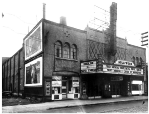
Hollywood Theatre (Toronto)
Movie theatre in Ontario, Canada
Distance: Approx. 315 meters
Latitude and longitude: 43.68953,-79.39447
The Hollywood Theatre was a movie theatre at 1519 Yonge Street in Toronto, Ontario. It opened in 1930 and was located on the east side of Yonge Street, north of St. Clair Avenue.
Weather in this IP's area
clear sky
19 Celsius
20 Celsius
17 Celsius
21 Celsius
1017 hPa
81 %
1017 hPa
1001 hPa
10000 meters
3.6 m/s
60 degree
07:00:51
19:22:24