Country:
 USA
USARegion:
City:
Latitude and Longitude:
Time Zone:
Postal Code:
IP information under different IP Channel
ip-api
Country
Region
City
ASN
Time Zone
ISP
Blacklist
Proxy
Latitude
Longitude
Postal
Route
IPinfo
Country
Region
City
ASN
Time Zone
ISP
Blacklist
Proxy
Latitude
Longitude
Postal
Route
MaxMind
Country
Region
City
ASN
Time Zone
ISP
Blacklist
Proxy
Latitude
Longitude
Postal
Route
Luminati
Country
USRegion
ny
City
albany
ASN
Time Zone
America/New_York
ISP
UUNET
Latitude
Longitude
Postal
db-ip
Country
Region
City
ASN
Time Zone
ISP
Blacklist
Proxy
Latitude
Longitude
Postal
Route
ipdata
Country
Region
City
ASN
Time Zone
ISP
Blacklist
Proxy
Latitude
Longitude
Postal
Route
Popular places and events near this IP address

Colonie (village), New York
Village in New York, United States
Distance: Approx. 1368 meters
Latitude and longitude: 42.72083333,-73.83416667
Colonie is a village in Albany County, New York, United States. The population was 7,793 at the 2010 census. The village of Colonie is within the town of Colonie.
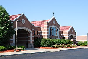
Colonie Central High School
School in Colonie, New York, US
Distance: Approx. 1724 meters
Latitude and longitude: 42.708526,-73.810216
Colonie Central High School is a public high school in the town of Colonie, with the postal address of Albany, New York. In 2005 it had 2225 students and 132 classroom teachers. It is part of the South Colonie Central School District.

New York State Department of Transportation
Department of the New York state government
Distance: Approx. 1056 meters
Latitude and longitude: 42.71361111,-73.81583333
The New York State Department of Transportation (NYSDOT) is the department of the New York state government responsible for the development and operation of highways, railroads, mass transit systems, ports, waterways and aviation facilities in the U.S. state of New York.

Colonie Center
Shopping mall in New York, United States
Distance: Approx. 1453 meters
Latitude and longitude: 42.71,-73.81611111
Colonie Center is a shopping mall located in Roessleville, New York, a suburb of Albany, at the intersection of Central Avenue, Wolf Road, and Interstate 87. Opening in 1966, it was the first enclosed shopping mall in New York's Capital Region. The two-story mall has an area of 1,340,610 square feet (124,547 m2) and 110 stores as well as a food court.

Heritage Park (Colonie, New York)
Abandoned sport stadium in Colonie, New York
Distance: Approx. 1915 meters
Latitude and longitude: 42.740193,-73.816967
Heritage Park was a stadium in Colonie, New York, USA. It was primarily used for baseball but was also used for high school and college football games. It had a capacity of 5,500.
Christian Brothers Academy (Albany, New York)
Private, day school in Albany, New York
Distance: Approx. 1083 meters
Latitude and longitude: 42.7325,-73.82055556
Christian Brothers Academy is a private, Catholic, college preparatory, junior and senior high school for boys founded in 1859 by the De La Salle Christian Brothers (See Institute of the Brothers of the Christian Schools). Christian Brothers Academy (CBA) is located in the town of Colonie, New York near the Albany International Airport on a 126-acre (0.51 km2) campus built in 1998. Christian Brothers Academy is independently run by a board of trustees.
Watervliet Shaker Historic District
Historic district in New York, United States
Distance: Approx. 1862 meters
Latitude and longitude: 42.73972222,-73.81833333
Watervliet Shaker Historic District, in Colonie, New York, is the site of the first Shaker community, established in 1776. The primary Shaker community, the Mount Lebanon Shaker Society, was started a bit later. Watervliet's historic 1848 Shaker meetinghouse has been restored and is used for public events, such as concerts.
Northway Shopping Center
Shopping center in New York State, U.S.
Distance: Approx. 1980 meters
Latitude and longitude: 42.70594444,-73.82458333
Northway Shopping Center (known as Northway Mall until 2012) is a big box retail center in Colonie, New York along Central Avenue (NY Route 5). From 1970 to 1999, it was an enclosed shopping mall with several out buildings. It is located across Central Avenue from Colonie Center, an enclosed shopping mall.

St. Francis Chapel (Colonie, New York)
Distance: Approx. 1242 meters
Latitude and longitude: 42.71763056,-73.80438611
St. Francis Chapel was a Catholic Franciscan chapel, sponsored by the Holy Name Province of the Order Friars Minor. It began in the Northway Mall in Colonie, New York, United States on December 28, 1970.
Center for Technology in Government
Distance: Approx. 1396 meters
Latitude and longitude: 42.722189,-73.800664
Center for Technology in Government is a research institution at the University at Albany in Albany, New York, that focuses on the development of innovative solutions to help government provide better public services through technology. Through applied research and partnerships (e.g. with the Major Cities of Europe IT Users Group), projects are undertaken that address the policy, management, and technology dimensions of information use in the public sector.
John Wolf Kemp House
Historic house in New York, United States
Distance: Approx. 1548 meters
Latitude and longitude: 42.72583333,-73.79916667
John Wolf Kemp House was a historic home located at Colonie in Albany County, New York. It was built about 1780 and was a 2-story, L-shaped frame farmhouse with a gable roof and five bays wide. It had a 1+1⁄2-story rear ell.

Transweb
Distance: Approx. 1395 meters
Latitude and longitude: 42.72225833,-73.80067778
Transweb Educational Services, founded in 2007 by Aditya Singhal and Nishant Sinha, is an online tutoring and educational website. The website provides educational resources to students from grade 4 to university level, through its five websites.
Weather in this IP's area
broken clouds
11 Celsius
11 Celsius
10 Celsius
12 Celsius
1012 hPa
90 %
1012 hPa
1002 hPa
10000 meters
3.6 m/s
230 degree
75 %
06:28:10
19:17:45