Country:
 USA
USARegion:
City:
Latitude and Longitude:
Time Zone:
Postal Code:
IP information under different IP Channel
ip-api
Country
Region
City
ASN
Time Zone
ISP
Blacklist
Proxy
Latitude
Longitude
Postal
Route
IPinfo
Country
Region
City
ASN
Time Zone
ISP
Blacklist
Proxy
Latitude
Longitude
Postal
Route
MaxMind
Country
Region
City
ASN
Time Zone
ISP
Blacklist
Proxy
Latitude
Longitude
Postal
Route
Luminati
Country
USRegion
ny
City
albany
ASN
Time Zone
America/New_York
ISP
UUNET
Latitude
Longitude
Postal
db-ip
Country
Region
City
ASN
Time Zone
ISP
Blacklist
Proxy
Latitude
Longitude
Postal
Route
ipdata
Country
Region
City
ASN
Time Zone
ISP
Blacklist
Proxy
Latitude
Longitude
Postal
Route
Popular places and events near this IP address

Schenectady station
Distance: Approx. 909 meters
Latitude and longitude: 42.8146,-73.9428
Schenectady station is an Amtrak intercity train station in Schenectady, New York. The station, constructed in 2018 is owned by the Capital District Transportation Authority which also owns Albany–Rensselaer station and Saratoga Springs station. Schenectady is served by five Amtrak routes.

Schenectady massacre
1690 attack in the Province of New York
Distance: Approx. 698 meters
Latitude and longitude: 42.8188,-73.9481
The Schenectady massacre was an attack against the colonial settlement of Schenectady in the English Province of New York on February 8, 1690. A raiding party of 114 French soldiers and militiamen, accompanied by 96 allied Mohawk and Algonquin warriors, attacked the unguarded community, destroying most of the homes, and killing or capturing most of its inhabitants. Sixty residents were killed, including 11 Black slaves.

Stockade Historic District
Historic district in New York, United States
Distance: Approx. 611 meters
Latitude and longitude: 42.81861111,-73.94638889
The Stockade Historic District is located in the northwest corner of Schenectady, New York, United States, on the banks of the Mohawk River. It is the oldest neighborhood in the city, continuously inhabited for over 300 years. Union College first held classes in a building within the district, and later it would be one of the termini of an early suspension bridge that was, at the time, the longest in North America.
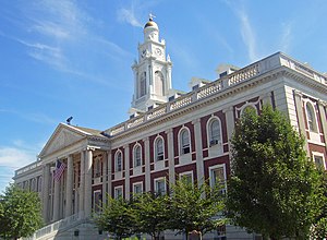
Schenectady City Hall
United States historic place
Distance: Approx. 998 meters
Latitude and longitude: 42.81388889,-73.93916667
Schenectady City Hall is the seat of government of the city of Schenectady, New York, United States. Designed by McKim, Mead, and White, the building was constructed between 1931 and 1933. It is located on the block between Clinton, Franklin, Jay and Liberty streets.

United States Post Office (Schenectady, New York)
United States historic place
Distance: Approx. 911 meters
Latitude and longitude: 42.81472222,-73.93888889
The U.S. Post Office in Schenectady, in the U.S. state of New York, is located at Jay and Liberty streets just north of City Hall. It serves the 12305, 12307 and 12308 ZIP codes, which covers the city. It is a brick Classical Revival building erected in 1912 and added onto extensively in 1933.

Union Street Historic District (Schenectady, New York)
Historic district in New York, United States
Distance: Approx. 867 meters
Latitude and longitude: 42.81583333,-73.93638889
The Union Street Historic District extends along a section of that street in Schenectady, New York, United States. Covering roughly two miles (3.2 km) of both sides of the street, it includes 184 buildings in its 65 acres (26 ha). Over the course of the 19th century, the city's development followed Union, one of the major through roads to the east, as it industrialized and expanded out of its colonial core on the banks of the Mohawk River.
H. S. Barney Building
Historic commercial building in New York, United States
Distance: Approx. 893 meters
Latitude and longitude: 42.81527778,-73.94555556
H. S. Barney Building is a historic department store complex located at Schenectady in Schenectady County, New York. The large commercial building consists of six sections constructed or acquired and linked between 1873 and 1923. It is predominantly brick in construction, but incorporates heavy timber framing, concrete, and limestone.
Edison Tech Center
Interactive learning center in Schenectady, New York
Distance: Approx. 979 meters
Latitude and longitude: 42.813941,-73.942478
The Edison Tech Center is an interactive learning center with a central emphasis on electricity and engineering. The organization was founded in 2001 under the name Edison Exploratorium, and changed to Edison Steinmetz Center and finally the Edison Tech Center in 2009. It is located at 136 Broadway, Schenectady, New York.
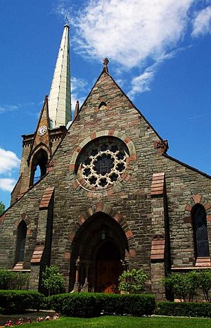
First Reformed Church of Schenectady
Distance: Approx. 783 meters
Latitude and longitude: 42.81698,-73.946975
First Reformed Church of Schenectady is located at 8 North Church Street in the Historic Stockade District of Schenectady, New York and is a member of the Reformed Church in America. The church was first organized in 1680 by Dutch settlers and was the first church established in the Mohawk Valley. The church, along with the Stockade District were added to the National Register of Historic Places in 1973 and again with a boundary increase in 1984 (#73001267).

First Presbyterian Church (Schenectady, New York)
Church in New York, United States
Distance: Approx. 652 meters
Latitude and longitude: 42.81738889,-73.94477778
First Presbyterian Church in Schenectady, New York is a historic Presbyterian Church in America congregation. The roots of the congregation go back to the 1730s. Episcopalians and Presbyterians had used the St.
Nott Street School
United States historic place
Distance: Approx. 873 meters
Latitude and longitude: 42.82055556,-73.93111111
Nott Street School is a historic school building located at Schenectady, Schenectady County, New York. It was originally built in 1877 as a four-room school, with an eight classroom addition completed in 1909. It is a two-story, red brick building above a stone and concrete raised basement.
Mohawk Harbor Event Center
Distance: Approx. 184 meters
Latitude and longitude: 42.82141389,-73.93999
The Mohawk Harbor Event Center is an indoor ice hockey rink currently under construction in Schenectady, New York. It is expected to be completed in time for the start of the 2025–26 season.
Weather in this IP's area
few clouds
11 Celsius
11 Celsius
10 Celsius
12 Celsius
1012 hPa
93 %
1012 hPa
1004 hPa
10000 meters
1.34 m/s
3.58 m/s
360 degree
22 %
06:28:35
19:18:20