Country:
 USA
USARegion:
City:
Latitude and Longitude:
Time Zone:
Postal Code:
IP information under different IP Channel
ip-api
Country
Region
City
ASN
Time Zone
ISP
Blacklist
Proxy
Latitude
Longitude
Postal
Route
IPinfo
Country
Region
City
ASN
Time Zone
ISP
Blacklist
Proxy
Latitude
Longitude
Postal
Route
MaxMind
Country
Region
City
ASN
Time Zone
ISP
Blacklist
Proxy
Latitude
Longitude
Postal
Route
Luminati
Country
USRegion
ny
City
troy
ASN
Time Zone
America/New_York
ISP
UUNET
Latitude
Longitude
Postal
db-ip
Country
Region
City
ASN
Time Zone
ISP
Blacklist
Proxy
Latitude
Longitude
Postal
Route
ipdata
Country
Region
City
ASN
Time Zone
ISP
Blacklist
Proxy
Latitude
Longitude
Postal
Route
Popular places and events near this IP address

Waterford (village), New York
Village in New York, United States
Distance: Approx. 850 meters
Latitude and longitude: 42.79111111,-73.67972222
Waterford is a village in Saratoga County, New York, United States. The population was 2,038 at the 2020 census. The name derives from the ford between the mainland and Peebles Island.
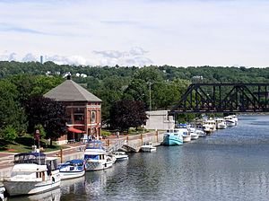
Waterford, New York
Town in New York, United States
Distance: Approx. 853 meters
Latitude and longitude: 42.791127,-73.679758
Waterford is a town in Saratoga County, New York, United States. The population was 8,208 at the 2020 census. The name of the town is derived from its principal village, also called Waterford.
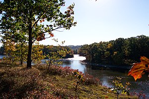
Peebles Island State Park
State park in New York, United States
Distance: Approx. 881 meters
Latitude and longitude: 42.782,-73.686
Peebles Island State Park is a 190-acre (0.77 km2) state park located at the confluence of the Mohawk and Hudson rivers in New York. A majority of the park is located in Saratoga County, with a smaller portion located in Albany County.

Lansingburgh, New York
Village in New York, United States
Distance: Approx. 735 meters
Latitude and longitude: 42.78333333,-73.66666667
Lansingburgh is a village in the north end of Troy. It was first laid out in lots and incorporated in 1771 by Abraham Jacob Lansing, who had purchased the land in 1763. In 1900, Lansingburgh became part of the City of Troy.
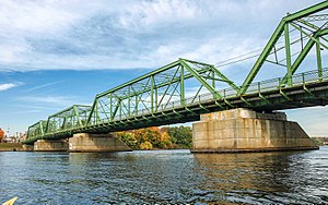
Troy–Waterford Bridge
Bridge in both in New York, United States
Distance: Approx. 531 meters
Latitude and longitude: 42.7887,-73.67386667
The Troy–Waterford Bridge carries U.S. Route 4 across the Hudson River in New York connecting Waterford with Troy. The bridge is two lanes wide, with sidewalks on both sides. The bridge serves as a replacement for the 1804-built Union Bridge, which burned on July 10, 1909.
WHAZ (AM)
Christian radio station in Troy, New York, United States
Distance: Approx. 1183 meters
Latitude and longitude: 42.77646667,-73.685675
WHAZ (1330 kHz) is a commercial AM radio station licensed to Troy, New York, and serving New York's Capital District. The station is locally owned by the Capital Media Corporation and broadcasts a Christian talk and teaching radio format. National religious leaders heard on WHAZ include Jim Daly, Charles Stanley, Joyce Meyer, Chuck Swindoll and David Jeremiah.

Day Peckinpaugh
The last self-propelled regularly scheduled commercial ship on the Erie canal.
Distance: Approx. 709 meters
Latitude and longitude: 42.77861111,-73.68
Day Peckinpaugh is a historic canal motorship berthed at the Matton Shipyard on Peebles Island, Cohoes in Albany County, New York, United States.

Trinity Church Lansingburgh
Historic church in New York, United States
Distance: Approx. 1075 meters
Latitude and longitude: 42.77444444,-73.67555556
Trinity Church Lansingburgh is a historic Episcopal church complex located at 585 Fourth Avenue in Troy, New York. The complex consists of the Gothic Revival style stone church (1869) designed by architect Henry C. Dudley, a Greek Revival style brick rectory (c. 1844), brick parish hall (1930), cemetery (1807) with approximately 240 graves, and a wrought iron fence (1901).: 3–4 It was listed on the National Register of Historic Places in 1995.
Matton Shipyard
United States historic place
Distance: Approx. 658 meters
Latitude and longitude: 42.77944444,-73.68055556
Matton Shipyard is a historic shipyard and canal boat service yard located on Van Schaick Island at Cohoes in Albany County, New York. It consists of eight extant buildings, various surviving features, and archaeological remains dating to the period 1916 to 1983 when the site functioned as a shipyard, repair facility, and towboat operation on the New York State Barge Canal and Champlain Canal. Extant buildings include the office / stores (c.
Powers Home
Historic house in New York, United States
Distance: Approx. 232 meters
Latitude and longitude: 42.78388889,-73.67277778
Powers Home, also known as Davenport Homestead, is a historic home located in the Lansingburgh section of Troy in Rensselaer County, New York. It was built in 1846 and is a temple style Greek Revival residence. It is a T-shaped residence with a two-story, three-bay, frame central block with two flanking wings and one long rear wing.

Ormsby-Laughlin Textile Companies Mill
United States historic place
Distance: Approx. 788 meters
Latitude and longitude: 42.78833333,-73.68333333
Ormsby-Laughlin Textile Companies Mill is a historic textile mill located at Waterford in Saratoga County, New York. It was built in 1894 and is a 4+1⁄2-story, Romanesque Revival style, brick industrial building with a gable roof. It features a 6+1⁄2-story tower at the center of the front facade.

Waterford Village Historic District (Waterford, New York)
Historic district in New York, United States
Distance: Approx. 784 meters
Latitude and longitude: 42.79055556,-73.67944444
Waterford Village Historic District is a 31-acre (13 ha) historic district in Waterford, New York that was listed on the National Register of Historic Places in 1977. The district dates to 1799 and includes Greek Revival, Late Victorian, and Federal architecture. The listing included 330 contributing buildings and one other contributing structure.
Weather in this IP's area
broken clouds
11 Celsius
11 Celsius
10 Celsius
13 Celsius
1012 hPa
94 %
1012 hPa
1011 hPa
10000 meters
3.6 m/s
230 degree
75 %
06:27:33
19:17:14