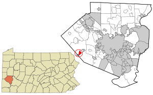
Country:
 USA
USARegion:
City:
Latitude and Longitude:
Time Zone:
Postal Code:
IP information under different IP Channel
ip-api
Country
Region
City
ASN
Time Zone
ISP
Blacklist
Proxy
Latitude
Longitude
Postal
Route
IPinfo
Country
Region
City
ASN
Time Zone
ISP
Blacklist
Proxy
Latitude
Longitude
Postal
Route
MaxMind
Country
Region
City
ASN
Time Zone
ISP
Blacklist
Proxy
Latitude
Longitude
Postal
Route
Luminati
Country
USRegion
pa
City
oakdale
ASN
Time Zone
America/New_York
ISP
UUNET
Latitude
Longitude
Postal
db-ip
Country
Region
City
ASN
Time Zone
ISP
Blacklist
Proxy
Latitude
Longitude
Postal
Route
ipdata
Country
Region
City
ASN
Time Zone
ISP
Blacklist
Proxy
Latitude
Longitude
Postal
Route
Popular places and events near this IP address

North Fayette Township, Pennsylvania
Township in Pennsylvania, United States
Distance: Approx. 3748 meters
Latitude and longitude: 40.43111111,-80.21416667
The Township of North Fayette is a township in Allegheny County, Pennsylvania, United States. The township is a suburb of Pittsburgh. The population was 16,166 at the 2020 census.

Oakdale, Pennsylvania
Borough in Pennsylvania, United States
Distance: Approx. 686 meters
Latitude and longitude: 40.39944444,-80.18555556
Oakdale is a borough in Allegheny County, Pennsylvania, United States. The population was 1,475 at the 2020 census. It is a suburb of Pittsburgh.

Sturgeon-Noblestown, Pennsylvania
CDP in Pennsylvania, United States
Distance: Approx. 3152 meters
Latitude and longitude: 40.38388889,-80.20916667
Sturgeon-Noblestown was a census-designated place (CDP) for the 2000 United States Census in Allegheny County, Pennsylvania, United States. The population was 1,764 at that time. In the 2010 census the CDP was split into the two separate CDP's of Sturgeon and Noblestown.

South Fayette Township School District
School district in Pennsylvania
Distance: Approx. 3063 meters
Latitude and longitude: 40.37991,-80.17237
The South Fayette Township School District is a suburban, public school district serving the Pittsburgh suburb of South Fayette Township, Pennsylvania. The district encompasses approximately 21 square miles (54 km2). In 2010, the district's population was 14,416 people.
Oakdale Air Force Station
Distance: Approx. 2253 meters
Latitude and longitude: 40.39722222,-80.16111111
Oakdale Air Force Station (ADC ID: RP-62, NORAD ID: Z-62) is a United States Air Force General Surveillance Radar station. It is located 1.3 miles (2.1 km) east of the Pittsburgh suburb of Oakdale, Pennsylvania. It was closed in 1969.
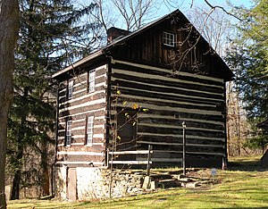
Walker-Ewing Log House
Log house in Pennsylvania, USA
Distance: Approx. 2224 meters
Latitude and longitude: 40.41119167,-80.16010833
The Walker-Ewing Log House is an historic, eighteenth century loghouse located in Collier Township, Allegheny County, Pennsylvania. Owned and managed by the Pioneers West Historical Society beginning in the 1990s, the home and land were acquired by the Allegheny Land Trust in 2020 with oversight responsibility for the building's preservation and easement given to the Western Pennsylvania Conservancy.
Oakdale Public School
United States historic place
Distance: Approx. 830 meters
Latitude and longitude: 40.3983,-80.1833
The Oakdale Public School at the corner of Hastings Avenue and Noblestown Road in Oakdale, Pennsylvania, United States was built in 1894 in the Romanesque Revival style. It was added to the National Register of Historic Places on March 28, 1997.
Walker-Ewing-Glass Log House
Log house in Pennsylvania, USA
Distance: Approx. 1937 meters
Latitude and longitude: 40.41801389,-80.16928056
The Walker-Ewing-Glass Log House is a log house located on Pinkerton Run Road in Settler's Cabin Park, North Fayette Township, Pennsylvania. It may have been built in the 1780s by a man named John Henry. In 1785, Isaac and Gabriel Walker acquired the land, and Gabriel built the nearby Walker-Ewing Log House around the same time.

Noblestown, Pennsylvania
Census-designated place in Pennsylvania, United States
Distance: Approx. 1820 meters
Latitude and longitude: 40.39527778,-80.20194444
Noblestown is a census-designated place (CDP) in Allegheny County, Pennsylvania, United States. The community was part of the Sturgeon-Noblestown CDP before later splitting into two separate CDPs in 2010, becoming Sturgeon and Noblestown. The population of Noblestown was 797 at the 2020 census.
Sturgeon, Pennsylvania
Census-designated place in Pennsylvania, United States
Distance: Approx. 3423 meters
Latitude and longitude: 40.385,-80.21527778
Sturgeon is a census-designated place (CDP) in Allegheny County, Pennsylvania, United States. The community was part of the Sturgeon-Noblestown CDP for the 2000 census, but was split into two separate CDP's for the 2010 census. The population of Sturgeon was 1,611 at the 2020 census.

Pittsburgh Botanic Garden
Distance: Approx. 1376 meters
Latitude and longitude: 40.4129,-80.1722
The Pittsburgh Botanic Garden is a botanical garden in Settler's Cabin Park in the Pittsburgh suburbs of Collier Township and North Fayette Township, United States. The garden spans across a total of 452 acres, making it among the top 10 largest American botanical gardens.

Pittsburgh Technical College
Private college in Pittsburgh, Pennsylvania
Distance: Approx. 2146 meters
Latitude and longitude: 40.4247,-80.18873
Pittsburgh Technical College (PTC) was a private college in Pittsburgh, Pennsylvania. The college, formerly Pittsburgh Technical Institute, which opened in 1946 and closed in 2024, had more than 30 career-focused programs in ten schools. Bachelor's and associate degrees are awarded, in addition to certificate programs.
Weather in this IP's area
clear sky
8 Celsius
8 Celsius
7 Celsius
9 Celsius
1019 hPa
90 %
1019 hPa
982 hPa
10000 meters
0.45 m/s
0.45 m/s
191 degree
06:55:24
19:41:27