Country:
 USA
USARegion:
City:
Latitude and Longitude:
Time Zone:
Postal Code:
IP information under different IP Channel
ip-api
Country
Region
City
ASN
Time Zone
ISP
Blacklist
Proxy
Latitude
Longitude
Postal
Route
IPinfo
Country
Region
City
ASN
Time Zone
ISP
Blacklist
Proxy
Latitude
Longitude
Postal
Route
MaxMind
Country
Region
City
ASN
Time Zone
ISP
Blacklist
Proxy
Latitude
Longitude
Postal
Route
Luminati
Country
USRegion
pa
City
pittsburgh
ASN
Time Zone
America/New_York
ISP
UUNET
Latitude
Longitude
Postal
db-ip
Country
Region
City
ASN
Time Zone
ISP
Blacklist
Proxy
Latitude
Longitude
Postal
Route
ipdata
Country
Region
City
ASN
Time Zone
ISP
Blacklist
Proxy
Latitude
Longitude
Postal
Route
Popular places and events near this IP address

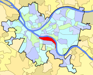
South Side (Pittsburgh)
Neighborhoods of Pittsburgh in Allegheny, Pennsylvania, United States
Distance: Approx. 668 meters
Latitude and longitude: 40.427,-79.976
South Side (or "Southside") is an area in Pittsburgh, Pennsylvania, United States, located along the Monongahela River across from Downtown Pittsburgh. The South Side is officially divided into two neighborhoods, South Side Flats and South Side Slopes. Both the Flats and the Slopes are represented on Pittsburgh City Council by Bruce Kraus.
South Side Flats
Neighborhood in Pittsburgh, Pennsylvania, United States
Distance: Approx. 637 meters
Latitude and longitude: 40.42882222,-79.98557778
The South Side Flats is a neighborhood in Pittsburgh, Pennsylvania's South Side area. It is located just south of the Monongahela River. The neighborhood has one of the City of Pittsburgh's largest concentrations of 19th-century homes, which has prompted outsiders to call the neighborhood the City's Georgetown.
Brew House Association
Distance: Approx. 578 meters
Latitude and longitude: 40.425503,-79.976156
The Brew House Association is an artist collective established in 1991 in the South Side Flats neighborhood of Pittsburgh, Pennsylvania. It is located at Mary and 21st Streets in a multi-story building that once housed the Duquesne Brewing Company. The lower floors of the building have been converted to gallery and theater space, including SPACE 101, an alternative exhibit gallery founded by the Brew House Association in 1994, while the upper floors have become studio and living areas for resident artists, and shared workshops for welding and pottery.
Keeling Coal Company
Distance: Approx. 632 meters
Latitude and longitude: 40.41833333,-79.97972222
The Keeling Coal Company (1861–1878) was a 19th-century coal mining company in Allegheny County, Pennsylvania. Its mines were located in the Pittsburgh Coalfield of western Pennsylvania.
South Side Park (Pittsburgh)
Distance: Approx. 549 meters
Latitude and longitude: 40.421,-79.977
South Side Park is an urban park in Pittsburgh. It is situated in a ravine that divides the South Side Slopes neighborhood, and extends to the location of the former Oliver Ormsby estate in Mount Oliver, Pennsylvania, Ormsby Manor.

UPMC Mercy South Side Outpatient Center
Hospital in Pennsylvania, United States
Distance: Approx. 471 meters
Latitude and longitude: 40.4256,-79.9776
UPMC Outpatient Center was a 209,000-square-foot (19,400 m2) outpatient facility that provides, among other services, Orthopaedic services, primary care services, and physicians offices to the residents of Pittsburgh's South Side neighborhood. UPMC Outpatient Center operates according to the directives established by the United States Conference of Catholic Bishops and will not provide or permit medical procedures that are contrary to the teachings of the Roman Catholic Church.
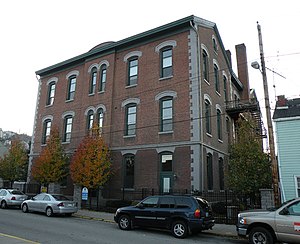
Birmingham Public School
United States historic place
Distance: Approx. 419 meters
Latitude and longitude: 40.42725278,-79.98369167
The Birmingham Public School is an historic American school building that is located in the South Side Flats neighborhood of Pittsburgh, Pennsylvania. Listed on the National Register of Historic Places in 1986, it currently functions as an apartment building.

City Theatre (Pittsburgh)
Theater company in Pennsylvania, US
Distance: Approx. 669 meters
Latitude and longitude: 40.429267,-79.985125
City Theatre is a professional theater company located in Pittsburgh's South Side. It specializes in productions of new plays and has commissioned new works by playwrights on the national theatre scene, including Christopher Durang, Adam Rapp, and Jeffrey Hatcher. Established in 1975 as the City Players under the direction of Marjorie Walker, it was originally composed mainly of Carnegie Mellon graduates and was part of Pittsburgh's Department of Parks and Recreation, performing at schools, parks, and housing projects.

Saint Michael's Roman Catholic Church & Rectory
Distance: Approx. 217 meters
Latitude and longitude: 40.42493611,-79.98436111
Saint Michael's Roman Catholic Church & Rectory (also known as St. Michael the Archangel Church, and currently called Angel's Arms Condominiums) is a former Roman Catholic church and rectory located at 21 Pius Street in the South Side Slopes neighborhood of Pittsburgh, Pennsylvania. The church was built from 1855 to 1861 and designed in Romanesque Revival style by architect Charles Bartberger (1824–1896).

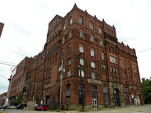
Duquesne Brewing Company
Brewery in Pittsburgh, Pennsylvania
Distance: Approx. 556 meters
Latitude and longitude: 40.42596,-79.97672
The Duquesne Brewing Company was a major brewery in Pittsburgh, Pennsylvania, from its founding in 1899 until its dissolution in 1972. The brand was revived under the name Duquesne Brewing Company in 2008, in order to re-establish the beer in Western Pennsylvania starting in the summer of 2010.

Duquesne Brewery Clock
American landmark
Distance: Approx. 621 meters
Latitude and longitude: 40.426158,-79.9759895
Located on the Duquesne Brewing Company building in Pittsburgh, Pennsylvania, the Duquesne Brewery Clock was the largest single-face clock in the world when it was installed in 1933. Over the years its face has been used to advertise numerous brands, beginning with Coca-Cola.

South Side Presbyterian Church
Distance: Approx. 580 meters
Latitude and longitude: 40.4275,-79.97797
The South Side Presbyterian Church is an historic, American church that is located in the South Side Flats neighborhood of Pittsburgh, Pennsylvania. It is a designated Pittsburgh historic landmark.
Weather in this IP's area
clear sky
9 Celsius
9 Celsius
7 Celsius
10 Celsius
1019 hPa
91 %
1019 hPa
989 hPa
10000 meters
1.31 m/s
3 m/s
277 degree
06:54:35
19:40:39