108.181.203.143 - IP Lookup: Free IP Address Lookup, Postal Code Lookup, IP Location Lookup, IP ASN, Public IP
Country:
Region:
City:
Location:
Time Zone:
Postal Code:
IP information under different IP Channel
ip-api
Country
Region
City
ASN
Time Zone
ISP
Blacklist
Proxy
Latitude
Longitude
Postal
Route
Luminati
Country
ASN
Time Zone
America/Toronto
ISP
AS40676
Latitude
Longitude
Postal
IPinfo
Country
Region
City
ASN
Time Zone
ISP
Blacklist
Proxy
Latitude
Longitude
Postal
Route
IP2Location
108.181.203.143Country
Region
california
City
walnut
Time Zone
America/Los_Angeles
ISP
Language
User-Agent
Latitude
Longitude
Postal
db-ip
Country
Region
City
ASN
Time Zone
ISP
Blacklist
Proxy
Latitude
Longitude
Postal
Route
ipdata
Country
Region
City
ASN
Time Zone
ISP
Blacklist
Proxy
Latitude
Longitude
Postal
Route
Popular places and events near this IP address

Diamond Bar, California
City in California, United States
Distance: Approx. 3772 meters
Latitude and longitude: 34.00166667,-117.82083333
Diamond Bar is a city in eastern Los Angeles County, California, United States. The 2020 census listed a population of 55,072. It is one of a few cities in California with a majority Asian population (59.24% as of 2020).

South San Jose Hills, California
Census-designated place in California, United States
Distance: Approx. 4316 meters
Latitude and longitude: 34.01138889,-117.90472222
South San Jose Hills is an unincorporated community and census-designated place in Los Angeles County, California, United States. The population was 20,551 at the 2010 census, up from 20,218 at the 2000 census.

Walnut, California
City in California, United States
Distance: Approx. 2144 meters
Latitude and longitude: 34.03333333,-117.86666667
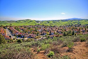
Walnut is a city in the eastern part of Los Angeles County in the U.S. state of California. According to the 2010 census, the city had a population of 29,172, and the population was estimated to be 29,685 in 2019. The greater Walnut Valley is located between the steep San Jose Hills to the north and the gently sloping Puente Hills to the south.

Mt. San Antonio College
Community college in Walnut, California
Distance: Approx. 3723 meters
Latitude and longitude: 34.047,-117.845
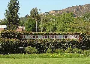
Mt. San Antonio College (Mt. SAC) is a public community college in Walnut, California.

Diamond Bar High School
Public school in Diamond Bar, California, United States
Distance: Approx. 4061 meters
Latitude and longitude: 33.9825,-117.8392
Diamond Bar High School (DBHS) is a public high school located in Diamond Bar, California, as part of the Walnut Valley Unified School District. Diamond Bar High School's mascot is the Brahma, and the school colors are purple and gold. Diamond Bar High School students participate in programs such as Advanced Placement (AP) and International Baccalaureate (IB).
Walnut High School
Public school in Walnut, California, United States
Distance: Approx. 1027 meters
Latitude and longitude: 34.02193,-117.85033
Walnut High School is a public high school located at Walnut, California, among the San Jose Hills of the San Gabriel Valley in Southern California. Walnut High School is also located within the Walnut Valley Unified School District, which has also been ranked by sources to be one of the top public school districts in all of Southern California. The school is a two-time National Blue Ribbon School (1992–93 and 1997–98), six-time California Distinguished school (1991, 1992, 1994, 1998, 2005 and 2009), and a California Gold Ribbon School (2017).
John A. Rowland High School
Public school
Distance: Approx. 4824 meters
Latitude and longitude: 33.98083333,-117.88972222
John A. Rowland High School is a public, four-year high school and International Baccalaureate (IB) World School in the city of Rowland Heights, California, United States. It is one of the two high schools in the Rowland Unified School District. It is located directly across from one of the district's elementary schools, Killian Elementary School.
Nogales High School (La Puente, California)
Public high school in La Puente, California, United States
Distance: Approx. 2899 meters
Latitude and longitude: 34.00996,-117.88892
Nogales High School is a public high school located in La Puente, California. It is a part of the Rowland Unified School District.

Industry station
Train station in Industry, California, US
Distance: Approx. 1431 meters
Latitude and longitude: 34.0079,-117.8456
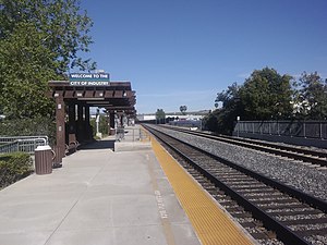
Industry station is a Metrolink train station located at 600 South Brea Canyon Road in Industry, California. Metrolink's Riverside Line trains between Los Angeles Union Station and Riverside–Downtown station stop here. It is owned and operated by the City of Industry.

Rancho Rincón de la Brea
Pre-statehood land grant, Los Angeles County
Distance: Approx. 4088 meters
Latitude and longitude: 33.98,-117.87
Rancho Rincón de la Brea (also called Rancho Cañada de la Brea) was a 4,452-acre (18.02 km2) Mexican land grant in present day Los Angeles County, California given in 1841 by Governor Juan Alvarado to Gil Maria Ybarra. The name means "Tar Gully Ranch" in Spanish. The one square league grant extended southward from San Jose Creek into the hills of Brea Canyon.
Hilmer Lodge Stadium
Distance: Approx. 3939 meters
Latitude and longitude: 34.04585,-117.836459
Hilmer Lodge Stadium on the Mt. San Antonio College (Mt. SAC) campus in Walnut, California, is the athletic stadium for the community college and home to the Mt.
Oxford School (California)
Private school in California, United States
Distance: Approx. 4620 meters
Latitude and longitude: 33.9863,-117.8939
Oxford School was a private middle and high school in Rowland Heights, California. It serves grades 6–12. As of 2017 Scott Adams is the principal.
Weather in this IP's area
clear sky
14 Celsius
12 Celsius
12 Celsius
16 Celsius
1018 hPa
20 %
1018 hPa
997 hPa
10000 meters
2.57 m/s
110 degree
