Country:
 USA
USARegion:
City:
Latitude and Longitude:
Time Zone:
Postal Code:
IP information under different IP Channel
ip-api
Country
Region
City
ASN
Time Zone
ISP
Blacklist
Proxy
Latitude
Longitude
Postal
Route
IPinfo
Country
Region
City
ASN
Time Zone
ISP
Blacklist
Proxy
Latitude
Longitude
Postal
Route
MaxMind
Country
Region
City
ASN
Time Zone
ISP
Blacklist
Proxy
Latitude
Longitude
Postal
Route
Luminati
Country
USRegion
in
City
vincennes
ASN
Time Zone
America/Chicago
ISP
CABLEONE
Latitude
Longitude
Postal
db-ip
Country
Region
City
ASN
Time Zone
ISP
Blacklist
Proxy
Latitude
Longitude
Postal
Route
ipdata
Country
Region
City
ASN
Time Zone
ISP
Blacklist
Proxy
Latitude
Longitude
Postal
Route
Popular places and events near this IP address

Vincennes, Indiana
City in Indiana, United States
Distance: Approx. 793 meters
Latitude and longitude: 38.67833333,-87.51611111
Vincennes is a city in, and the county seat of, Knox County, Indiana, United States. It is located on the lower Wabash River in the southwestern part of the state, nearly halfway between Evansville and Terre Haute. It was founded in 1732 by French fur traders, including the namesake François-Marie Bissot, Sieur de Vincennes.

Vincennes University
Public university in Vincennes, Indiana, US
Distance: Approx. 1954 meters
Latitude and longitude: 38.68833333,-87.52
Vincennes University (VU) is a public college with its main campus in Vincennes, Indiana, United States. Founded in 1801 as Jefferson Academy, VU is the oldest public institution of higher learning in Indiana. VU was chartered in 1806 as the Indiana Territory's four-year university and remained the state of Indiana's sole publicly funded four-year university until the establishment of Indiana University in 1820.

Grouseland
Historic house in Indiana, United States
Distance: Approx. 1917 meters
Latitude and longitude: 38.68548889,-87.52600556
Grouseland, the William Henry Harrison Mansion and Museum, is a National Historic Landmark important for its Federal-style architecture and role in American history. The two-story, red brick home was built between 1802 and 1804 in Vincennes, Indiana, for William Henry Harrison (1773–1841) during his tenure from 1801 to 1812 as the first governor of the Indiana Territory. The residence was completed in 1804, and Harrison reportedly named it Grouseland due to the abundance of grouse in the area.
Rivet High School (Vincennes, Indiana)
Private, coeducational school in Vincennes, , Indiana, United States
Distance: Approx. 2010 meters
Latitude and longitude: 38.67805556,-87.53444444
Jean Francois Rivet High School, Vincennes Rivet High School, or simply Rivet High School (within Vincennes) is a private, Roman Catholic high school in Vincennes, Indiana. It is part of the Roman Catholic Diocese of Evansville.
Pantheon Theatre
American theatre
Distance: Approx. 1643 meters
Latitude and longitude: 38.677754,-87.530046
The Pantheon Theatre was constructed in 1919 on the corner of 5th and Main Street in Vincennes, Indiana. It was built to hold 1200 people. One of the highest paid interior decorators in the world was hired to supervise the decorating of the theatre.

Indiana Territorial Capitol
United States historic place
Distance: Approx. 1835 meters
Latitude and longitude: 38.685,-87.52527778
The Indiana Territorial Capitol, also known as the Indiana Territory State Memorial and Legislative Hall, is part of a state historical site in Vincennes, Indiana. Part of a row of buildings located across from Vincennes University, the building was the center of government for the Indiana Territory from 1800 to 1813. It was built between 1800 and 1805, and is a simple two-story frame building.
Good Samaritan Hospital (Vincennes)
Hospital in Indiana, United States
Distance: Approx. 1715 meters
Latitude and longitude: 38.67318611,-87.53244444
Good Samaritan Hospital is located in Vincennes, Indiana. It is the main hospital for Knox County, Indiana and Lawrence County, Illinois. It is located along Willow Street and Sixth Street on Vincennes' South Side.

Pyramid Mound
United States historic place
Distance: Approx. 595 meters
Latitude and longitude: 38.67055556,-87.50611111
Pyramid Mound, designated 12k14, is a locally important archaeological site at the city of Vincennes in the southwestern part of the U.S. state of Indiana. Located on the city's edge, this substantial loess hill bears evidence of prehistoric occupation, and it is a landmark to the city's contemporary residents.

Old State Bank (Vincennes, Indiana)
Historic bank building in Indiana, United States
Distance: Approx. 1888 meters
Latitude and longitude: 38.68083333,-87.53111111
The Old State Bank, also known as the Second State Bank, Vincennes Branch, is a historic bank building located at Vincennes, Knox County, Indiana. It was built in 1838, and is a 2+1⁄2-story, Greek Revival style brick building. The building measures 36 feet wide and 48 feet deep.

Hack and Simon Office Building
United States historic place
Distance: Approx. 1532 meters
Latitude and longitude: 38.68416667,-87.52027778
Hack and Simon Office Building, also known as the Eagle Brewery Office Building, is a historic office building located at Vincennes, Knox County, Indiana. It was built in 1885, and is a two-story, Romanesque Revival style red brick building, with a 1+1⁄2-story rear addition built about 1910. It rests on a limestone foundation and has gable roofs on the two sections.

Vincennes Fortnightly Club
United States historic place
Distance: Approx. 1366 meters
Latitude and longitude: 38.67916667,-87.52527778
Vincennes Fortnightly Club is a historic Women's club clubhouse located at Vincennes, Knox County, Indiana. It was built in 1928, and is a two-story, Colonial Revival style brick and Indiana limestone building. The tripartite front facade features arched openings and a decorative metal railed balcony on the second floor.
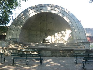
Gregg Park
United States historic place
Distance: Approx. 1743 meters
Latitude and longitude: 38.685,-87.50222222
Gregg Park is a historic public park and national historic district located at Vincennes, Knox County, Indiana. The park was dedicated in 1931, and developed by the Works Progress Administration (WPA) in 1938–1939. The WPA constructed a limestone shelterhouse, concrete Moderne style bandshell / grandstand, the brick main entrance gate, and horseshoe pits.
Weather in this IP's area
clear sky
17 Celsius
16 Celsius
16 Celsius
17 Celsius
1018 hPa
51 %
1018 hPa
1002 hPa
10000 meters
2.06 m/s
350 degree
06:51:48
18:23:21