Country:
 Canada
Region:
City:
Latitude and Longitude:
Time Zone:
Postal Code:
IP information under different IP Channel
ip-api
Country
Region
City
ASN
Time Zone
ISP
Blacklist
Proxy
Latitude
Longitude
Postal
Route
IPinfo
Country
Region
City
ASN
Time Zone
ISP
Blacklist
Proxy
Latitude
Longitude
Postal
Route
MaxMind
Country
Region
City
ASN
Time Zone
ISP
Blacklist
Proxy
Latitude
Longitude
Postal
Route
Luminati
Country
CARegion
on
City
toronto
ASN
Time Zone
America/Toronto
ISP
ROGERS-COMMUNICATIONS
Latitude
Longitude
Postal
db-ip
Country
Region
City
ASN
Time Zone
ISP
Blacklist
Proxy
Latitude
Longitude
Postal
Route
ipdata
Country
Region
City
ASN
Time Zone
ISP
Blacklist
Proxy
Latitude
Longitude
Postal
Route
Popular places and events near this IP address

Yorkdale Shopping Centre
Shopping mall in North York, Toronto
Distance: Approx. 418 meters
Latitude and longitude: 43.725599,-79.452696
Yorkdale Shopping Centre, Yorkdale Mall, or simply Yorkdale, is a major retail shopping centre in Toronto, Ontario, Canada. Located at the southwest corner of the interchange between Highway 401 and Allen Road, it opened in 1964 as the largest enclosed shopping mall in the world. Yorkdale is currently the third largest shopping mall in Canada by floor space and has the highest sales per unit area of any mall in Canada, with current merchandise sales levels at roughly CA$1,905 per square foot (CA$20,505.25 per square metre).

Lawrence Heights
Neighbourhood in Toronto, Ontario, Canada
Distance: Approx. 579 meters
Latitude and longitude: 43.719,-79.45
Lawrence Heights is a neighbourhood in Toronto, Ontario, Canada. It is located north-west of central Toronto, in the district of North York. The neighbourhood is roughly bounded by Lawrence Avenue to the south, Yorkdale Road to the north, Varna Drive to the east and Dufferin Street to the west.

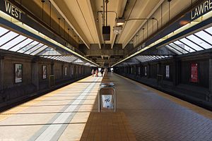
Yorkdale station
Toronto subway station
Distance: Approx. 90 meters
Latitude and longitude: 43.72472222,-79.4475
Yorkdale is a subway station on Line 1 Yonge–University in Toronto, Ontario, Canada. It is located in the median of the William R. Allen Road just south of Highway 401. Opened in 1978, the station is named after the nearby Yorkdale Shopping Centre, to which it is connected by an enclosed walkway.
Lawrence West station
Toronto subway station
Distance: Approx. 960 meters
Latitude and longitude: 43.71583333,-79.44416667
Lawrence West is a subway station on Line 1 Yonge–University in Toronto, Ontario, Canada. It is located in the median of William R. Allen Road at Lawrence Avenue West. The station serves the local communities of Lawrence Heights, Lawrence Manor and Glen Park, and nearby destinations such as the Columbus Centre, Lawrence Heights Community Recreation Centre and Lawrence Allen Centre.

Eglinton—Lawrence (federal electoral district)
Federal electoral district in Ontario, Canada
Distance: Approx. 779 meters
Latitude and longitude: 43.717,-79.448
Eglinton—Lawrence is a federal electoral district in Ontario, Canada, that has been represented in the House of Commons of Canada since 1979. It covers a portion of Toronto northwest of downtown. It stretches from Yonge Street in the east to Caledonia in the west and from Highway 401 in the north to Eglinton Avenue in the south.

Yorkdale Bus Terminal
Bus terminal in Toronto, Ontario, Canada
Distance: Approx. 159 meters
Latitude and longitude: 43.72527778,-79.44888889
Yorkdale Bus Terminal, located at 1 Yorkdale Road, Toronto, Ontario, Canada occupies the lowest level of an office building adjacent to Yorkdale Shopping Centre and is connected directly to Yorkdale subway station by a pedestrian bridge. Its creation was announced by James Snow, the Ontario Minister of Transportation and Communications, in March 1977. Construction of the station started soon afterward and was expected to be completed by late 1977.
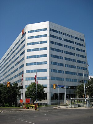
CIBC 750 Lawrence
Office complex in Toronto, Ontario, Canada
Distance: Approx. 937 meters
Latitude and longitude: 43.715691,-79.449837
CIBC 750 Lawrence is a two-tower office complex in Toronto, Ontario, Canada, built in the early 1980s. It is part of Canadian Imperial Bank of Commerce's (CIBC) head office operations outside of Commerce Court and the main headquarters of CIBC Credit Card Services, including Visa call centres and Visa operations. Employees in Visa are members of the Steel Workers Union in Toronto, USW Local 8300.

Lawrence Manor
Neighbourhood in Toronto, Ontario, Canada
Distance: Approx. 892 meters
Latitude and longitude: 43.725,-79.437
Lawrence Manor is a neighbourhood in the city of Toronto, Ontario, Canada. This neighbourhood is bounded by Bathurst Street on the east, Highway 401 to the north, the Allen to the west, and Lawrence Avenue to the south. The western side of the area borders along Bathurst Heights and the large public housing project.

Universal Man
Distance: Approx. 648 meters
Latitude and longitude: 43.725526,-79.4557739
Universal Man is a sculpture by Gerald Gladstone located outside the Yorkdale Shopping Centre in North York, Toronto, Ontario, Canada, since 1994. The 6.5-metre (21 ft) bronze figure was originally located in a prominent location at the foot of the CN Tower, there located to "emphasize the human aspects of the project". It was commissioned by CN Rail in 1972 at a cost of approximately $100,000 (approximately $717,000 in 2023 dollars) and the statue was unveiled in 1976.

John Polanyi Collegiate Institute
High school in Toronto, Ontario, Canada
Distance: Approx. 955 meters
Latitude and longitude: 43.717586,-79.440122
John Polanyi Collegiate Institute (JPCI), formerly Sir Sandford Fleming Secondary School is a public high school in Toronto, Ontario, Canada. It is housed in the former Bathurst Heights Secondary School building. It is located in the North York district, near Lawrence Avenue West and Allen Road in the area of Lawrence Heights.

Eglinton—Lawrence (provincial electoral district)
Provincial electoral district in Ontario, Canada
Distance: Approx. 724 meters
Latitude and longitude: 43.7175,-79.4483
Eglinton—Lawrence is a provincial electoral district in Toronto, Ontario, Canada. It elects one member to the Legislative Assembly of Ontario. It was created in 1999 from parts of Lawrence, York Mills, Wilson Heights, Oakwood, St.

Lawrence Allen Centre
Shopping mall in Toronto
Distance: Approx. 819 meters
Latitude and longitude: 43.71666667,-79.44722222
The Lawrence Allen Centre, formerly Lawrence Square Shopping Centre, is a shopping centre located in Toronto, Ontario, Canada. Owned by RioCan, it is one of the city's twenty largest malls. It is located on Lawrence Avenue West, west of Allen Road, in the neighbourhood of Lawrence Heights, the district of North York.
Weather in this IP's area
clear sky
14 Celsius
13 Celsius
12 Celsius
16 Celsius
1033 hPa
65 %
1033 hPa
1011 hPa
10000 meters
3.09 m/s
220 degree
07:36:11
18:29:09