Country:
 Canada
Region:
City:
Latitude and Longitude:
Time Zone:
Postal Code:
IP information under different IP Channel
ip-api
Country
Region
City
ASN
Time Zone
ISP
Blacklist
Proxy
Latitude
Longitude
Postal
Route
IPinfo
Country
Region
City
ASN
Time Zone
ISP
Blacklist
Proxy
Latitude
Longitude
Postal
Route
MaxMind
Country
Region
City
ASN
Time Zone
ISP
Blacklist
Proxy
Latitude
Longitude
Postal
Route
Luminati
Country
CARegion
on
City
toronto
ASN
Time Zone
America/Toronto
ISP
ROGERS-COMMUNICATIONS
Latitude
Longitude
Postal
db-ip
Country
Region
City
ASN
Time Zone
ISP
Blacklist
Proxy
Latitude
Longitude
Postal
Route
ipdata
Country
Region
City
ASN
Time Zone
ISP
Blacklist
Proxy
Latitude
Longitude
Postal
Route
Popular places and events near this IP address
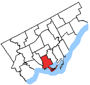
Trinity—Spadina (federal electoral district)
Former Canadian federal electoral district
Distance: Approx. 689 meters
Latitude and longitude: 43.65,-79.406
Trinity—Spadina was a federal electoral district in Ontario, Canada, that was represented in the House of Commons of Canada from 1988 to 2015. It generally encompassed the western portion of Downtown Toronto. The riding was a battle ground between the NDP and the Liberals.
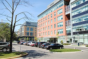
Centre for Addiction and Mental Health
Hospital in Ontario, Canada
Distance: Approx. 477 meters
Latitude and longitude: 43.64455,-79.41761
The Centre for Addiction and Mental Health (CAMH, pronounced KAM-aytch, French: Centre de toxicomanie et de santé mentale) is a psychiatric teaching hospital located in Toronto and ten community locations throughout the province of Ontario, Canada. It reports being the largest research facility in Canada for mental health and addictions. The hospital was formed in 1998 from the amalgamation of four separate institutions – the Queen Street Mental Health Centre, the Clarke Institute of Psychiatry, the Addiction Research Foundation, and the Donwood Institute.

Trinity Bellwoods Park
Public park in Toronto, Ontario, Canada
Distance: Approx. 25 meters
Latitude and longitude: 43.64777778,-79.41416667
Trinity Bellwoods Park is a public park located in Toronto, Ontario, Canada, bordered by Queen Street West on the south and Dundas Street on the north. The western boundary of the park is Crawford Street, several hundred feet before Crawford intersects with Dundas St. West, the park juts toward Shaw Street, westside of the Crawford Street Bridge.

Poor Alex Theatre
Former theatre company in Toronto, Ontario, Canada
Distance: Approx. 707 meters
Latitude and longitude: 43.652181,-79.407501
Poor Alex Theatre was a theatre company based in Toronto, Ontario, Canada. The Poor Alex opened in Toronto's Annex neighbourhood in the 1960s in a property owned by Ed Mirvish and took its name as a parody of the Mirvish-owned Royal Alexandra Theatre. A small theatre venue, it hosted a comedy and off Broadway-style productions and was the original home of the "Jest Society", which later became famous as the Royal Canadian Air Farce.

St. Matthias, Bellwoods
Church in Ontario, Canada
Distance: Approx. 239 meters
Latitude and longitude: 43.647719,-79.411154
St. Matthias, Bellwoods is a small inclusive Anglo-Catholic parish of the Anglican Church of Canada located in Toronto, Ontario, Canada. The cornerstone was laid in 1873 and the building opened January 4, 1874.

Crawford Street Bridge
Bridge in Ontario, Canada
Distance: Approx. 149 meters
Latitude and longitude: 43.64916667,-79.415
Crawford Street Bridge is one of two known bridges that once spanned over Garrison Creek valley — the actual creek disappeared as brick sewer by the 1920s) in Toronto, Ontario, Canada, and buried intact in the 20th century. The bridge shares design features with the larger Prince Edward Viaduct. The Crawford Bridge was a triple span Arch bridge built in 1914 to 1915 to replace an early wooden bridge (1884) that spanned Garrison Creek in the area known today as Trinity-Bellwoods.

Trinity-Bellwoods
Neighbourhood in Toronto, Ontario, Canada
Distance: Approx. 488 meters
Latitude and longitude: 43.64666667,-79.40833333
Trinity-Bellwoods is an inner city neighbourhood in Toronto, Ontario, Canada. It is bounded on the east by Bathurst Street, on the north by College Street, on the south by Queen Street West, and by Dovercourt Road on the west. It has a large Portuguese (mostly originally from the Azores and Madeira islands) and Brazilian community, and many local Portuguese-Canadian businesses are located along Dundas Street West, continuing west into Little Portugal; this stretch further west along Dundas is known as Rua Açores.
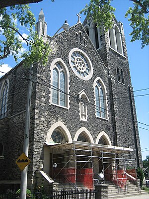
St. Francis of Assisi (Toronto)
Church in Ontario, Canada
Distance: Approx. 614 meters
Latitude and longitude: 43.65351,-79.41449
Saint Francis of Assisi is a Roman Catholic church founded in 1902 in Toronto, Ontario, Canada. It is located in the west end neighbourhood of Little Italy and Trinity-Bellwoods and within the Roman Catholic Archdiocese of Toronto.
Killing of Sammy Yatim
Police shooting
Distance: Approx. 342 meters
Latitude and longitude: 43.65091667,-79.41277778
The death of Sammy Yatim occurred early in the morning of July 27, 2013, in Toronto, Ontario, Canada. Yatim, an 18-year-old Toronto male armed with a switchblade knife, was shot at nine times, and was hit by eight of the shots fired by 30-year-old Toronto Police Service (TPS) officer James Forcillo. After being shot, while lying on the floor of the streetcar he was tasered.

The Dakota Tavern
Distance: Approx. 562 meters
Latitude and longitude: 43.64977,-79.42063
The Dakota Tavern is a live music venue and bar in Toronto, Ontario, Canada.

Cathedral of the Nativity of the Mother of God (Toronto)
Slovak Byzantine Catholic cathedral in Canada
Distance: Approx. 294 meters
Latitude and longitude: 43.64895,-79.4175
The Cathedral of the Nativity of the Mother of God is the cathedral church of the Exarchate of Saints Cyril and Methodius of Toronto, located on Shaw Street in Toronto, Canada. Ministering to members of the Slovak Byzantine Catholic Church exarchate, it falls under the jurisdiction of the Ruthenian Greek Catholic Church.

Lakeview Restaurant
Diner in Toronto, Ontario, Canada
Distance: Approx. 535 meters
Latitude and longitude: 43.6496,-79.42036
Lakeview Restaurant has been a traditional diner in Toronto, Canada, since 1932. It has been featured in films, television programs, and other Canadiana. The menu offers classic diner style dining from burgers, brunch, milkshakes, craft beers, and specialty sandwiches.
Weather in this IP's area
overcast clouds
9 Celsius
6 Celsius
7 Celsius
10 Celsius
1014 hPa
79 %
1014 hPa
1002 hPa
10000 meters
4.63 m/s
270 degree
100 %
06:49:50
19:40:51