108.165.152.51 - IP Lookup: Free IP Address Lookup, Postal Code Lookup, IP Location Lookup, IP ASN, Public IP
Country:
Region:
City:
Location:
Time Zone:
Postal Code:
IP information under different IP Channel
ip-api
Country
Region
City
ASN
Time Zone
ISP
Blacklist
Proxy
Latitude
Longitude
Postal
Route
Luminati
Country
ASN
Time Zone
America/Chicago
ISP
Cloudflare London, LLC
Latitude
Longitude
Postal
IPinfo
Country
Region
City
ASN
Time Zone
ISP
Blacklist
Proxy
Latitude
Longitude
Postal
Route
IP2Location
108.165.152.51Country
Region
rajasthan
City
jaipur
Time Zone
Asia/Kolkata
ISP
Language
User-Agent
Latitude
Longitude
Postal
db-ip
Country
Region
City
ASN
Time Zone
ISP
Blacklist
Proxy
Latitude
Longitude
Postal
Route
ipdata
Country
Region
City
ASN
Time Zone
ISP
Blacklist
Proxy
Latitude
Longitude
Postal
Route
Popular places and events near this IP address

Jantar Mantar, Jaipur
UNESCO World Heritage Site in Jaipur
Distance: Approx. 1169 meters
Latitude and longitude: 26.92472,75.82444
The Jantar Mantar is a collection of 19 astronomical instruments built by the Rajput king Sawai Jai Singh, the founder of Jaipur, Rajasthan. The monument was completed in 1734. It features the world's largest stone sundial, and is a UNESCO World Heritage Site.

Jantar Mantar
Astronomical observatories
Distance: Approx. 1175 meters
Latitude and longitude: 26.92444444,75.82486111
A Jantar Mantar (Hindustani pronunciation: [d͡ʒən̪t̪ər mən̪t̪ər]) is an assembly of stone-built astronomical instruments, designed to be used with the naked eye. There were five Jantar Mantars in India. All were built at the command of the Rajah Jai Singh II, who had a keen interest in mathematics, architecture and astronomy.

St Xavier's School, Jaipur
Private primary and secondary school in Jaipur, Rajasthan, India
Distance: Approx. 866 meters
Latitude and longitude: 26.912446,75.809467
St Xavier's Senior Secondary School is a private Catholic secondary school located in Jaipur, in Rajasthan in north-western India. The school was established by the Jesuits in 1943 in this name. The Jesuits took over St.
Maharaja College, Jaipur
College in Jaipur, India
Distance: Approx. 710 meters
Latitude and longitude: 26.9106,75.81501111
University Maharaja's College is a college in Jaipur, the capital of the Rajasthan state in India. Established in 1844 by Sawai Ram Singh II, it has been affiliated with University of Rajasthan since 1947. Maharaja college offers course on campus in Bachelor of Science (BSc) and Bachelor of Computer Application (B.C.A) at Undergraduate (U.G.) level.
Ram Niwas Garden
Garden in Jaipur, Rajasthan
Distance: Approx. 260 meters
Latitude and longitude: 26.91528,75.81869
Ram Niwas Garden is a garden situated in Jaipur city in Indian state of Rajasthan, built by Maharaja Sawai Ram Singh of Jaipur in 1868.

Raj Mandir Cinema
Cinema in Jaipur, India
Distance: Approx. 665 meters
Latitude and longitude: 26.9154985,75.8101639
Raj Mandir Cinema is a movie theatre in Jaipur in Rajasthan state in India. Situated on the Bhagwan Das Road, near M.I. Road, the meringue-shaped auditorium opened in 1976, and over the years has seen many movie premieres of Hindi films, and has become a popular symbol of Jaipur. The theatre often referred to as 'Cinema Ka Mandir' is equipped with the latest technology in sound and projection with Dolby Atmos and SLS speakers, the first in the state of Rajasthan.

Albert Hall Museum
Museum in Jaipur, Rajasthan, India
Distance: Approx. 624 meters
Latitude and longitude: 26.91179,75.81953
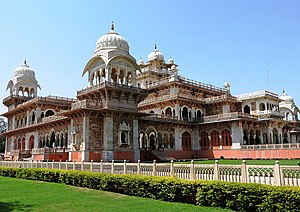
The Albert Hall Museum in Jaipur is the oldest museum of the state and functions as the state museum of Rajasthan, India. The building is situated in Ram Niwas garden outside the city wall opposite New gate and is a fine example of Indo-Saracenic architecture. It is also called the Government Central Museum.
LMB Hotel
Distance: Approx. 937 meters
Latitude and longitude: 26.919517,75.825633
Lakshmi Misthan Bhandar Hotel, popularly known as just LMB, is a well-known hotel, restaurant and sweet shop in Jaipur city in Rajasthan state in India. Established in 1727, it is located in downtown Jaipur in Johari Bazar. The hotel is said to be the first three star hotel of the state.
Jaipur Zoo
Zoo in Jaipur, Rajasthan
Distance: Approx. 692 meters
Latitude and longitude: 26.9122356,75.8214355
Jaipur Zoo is in the city of Jaipur in Rajasthan state in India. The zoo was opened in 1877 and is located near to the Albert Hall Museum and Ram Nivas Garden. It is divided into two parts: one for mammals and other for birds and reptiles.
Adarsh Nagar, Rajasthan Assembly constituency
Legislative Assembly constituency in Rajasthan State, India
Distance: Approx. 825 meters
Latitude and longitude: 26.91,75.82
Adarsh Nagar is one of the 200 Legislative Assembly constituencies of Rajasthan state in India. It is in Jaipur district and is a segment of Jaipur (Lok Sabha constituency). This seat came into existence after the 2008 delimitation exercise.
Tarkeshwar Nath Temple
Hindu temple in Jaipur, Rajasthan
Distance: Approx. 902 meters
Latitude and longitude: 26.922964,75.822593
Tarkeshwar Nath Temple (Hindi: ताडकेश्वर महादेव मंदिर) is a popular temple of the Lord Shiva in the Jaipur city in the state of Rajasthan, India. This temple is located on a green hill in the Choura Rasta, area of Jaipur. It is a popular temple of the Lord Shiva.
Kishanpole Assembly constituency
Legislative Assembly constituency in Rajasthan State, India
Distance: Approx. 484 meters
Latitude and longitude: 26.92,75.82
Kishanpole is one of the 200 Legislative Assembly constituencies of Rajasthan state in India. It is in Jaipur district and is a segment of Jaipur Lok Sabha seat.
Weather in this IP's area
haze
15 Celsius
14 Celsius
15 Celsius
15 Celsius
1015 hPa
67 %
1015 hPa
964 hPa
1800 meters
6.69 m/s
80 degree
40 %