108.161.206.201 - IP Lookup: Free IP Address Lookup, Postal Code Lookup, IP Location Lookup, IP ASN, Public IP
Country:
Region:
City:
Location:
Time Zone:
Postal Code:
ISP:
ASN:
language:
User-Agent:
Proxy IP:
Blacklist:
IP information under different IP Channel
ip-api
Country
Region
City
ASN
Time Zone
ISP
Blacklist
Proxy
Latitude
Longitude
Postal
Route
db-ip
Country
Region
City
ASN
Time Zone
ISP
Blacklist
Proxy
Latitude
Longitude
Postal
Route
IPinfo
Country
Region
City
ASN
Time Zone
ISP
Blacklist
Proxy
Latitude
Longitude
Postal
Route
IP2Location
108.161.206.201Country
Region
north carolina
City
aulander
Time Zone
America/New_York
ISP
Language
User-Agent
Latitude
Longitude
Postal
ipdata
Country
Region
City
ASN
Time Zone
ISP
Blacklist
Proxy
Latitude
Longitude
Postal
Route
Popular places and events near this IP address

Bertie County, North Carolina
County in North Carolina, United States
Distance: Approx. 8726 meters
Latitude and longitude: 36.06,-76.96
Bertie County ( bur-TEE) is a county located in the northeast area of the U.S. state of North Carolina. As of the 2020 census, the population was 17,934. Its county seat is Windsor.
Askewville, North Carolina
Town in North Carolina, United States
Distance: Approx. 9324 meters
Latitude and longitude: 36.11166667,-76.94111111
Askewville is a town in Bertie County, North Carolina, United States. The population was 184 at the 2020 census.

Hope Plantation
Historic house in North Carolina, United States
Distance: Approx. 8948 meters
Latitude and longitude: 36.1775,-77.01916667
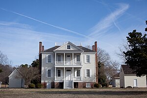
Hope Plantation, built in 1803, is an early house built in the Palladian mode of the Federal style, located on the Carolina Coastal Plain, near Windsor, North Carolina, in the United States. The plantation house was built by David Stone, a member of the coastal Carolina planter class, later Governor of North Carolina and a United States senator. One of the finest examples of Palladian design built in timber, the manor house is slightly modified by neo-classical elements.
King-Freeman-Speight House
Historic house in North Carolina, United States
Distance: Approx. 5244 meters
Latitude and longitude: 36.07722222,-77.095
King-Freeman-Speight House, also known as Francis Speight House, is a historic plantation house located at Republican, Bertie County, North Carolina. It was built in two sections, with the oldest built between 1808 and 1828. The older section forms the basis of the current rear wing.

King House (Windsor, North Carolina)
Historic house in North Carolina, United States
Distance: Approx. 8026 meters
Latitude and longitude: 36.03027778,-77.01916667
King House, also known as King-Bazemore House, is a historic plantation house located near Windsor, Bertie County, North Carolina. It was built in 1763, and is a 1+1⁄2-story, frame dwelling with brick ends. It has a gambrel roof and features two interior T-stack end chimneys.

William H. Lee House
Historic house in North Carolina, United States
Distance: Approx. 9998 meters
Latitude and longitude: 36.1425,-77.14138889
William H. Lee House, also known as Billy Lee Farm, is a historic home located at Lewiston, Bertie County, North Carolina. It was built about 1820, and is a two-story, three-bay, hall and parlor plan frame Federal style I-house. It has a side gable roof and rests on a brick pier foundation.
Republican, North Carolina
Unincorporated community in North Carolina, United States
Distance: Approx. 2403 meters
Latitude and longitude: 36.0825,-77.06
Republican is an unincorporated community in Bertie County, North Carolina, United States. The community is 8.6 miles (13.8 km) northwest of Windsor. The King-Freeman-Speight House, which is listed on the National Register of Historic Places, is located near Republican.
Snakebite Township, Bertie County, North Carolina
Distance: Approx. 1519 meters
Latitude and longitude: 36.0908,-77.0566
Snakebite Township is an inactive township in Bertie County, in the U.S. state of North Carolina.
Weather in this IP's area
light snow
-7 Celsius
-13 Celsius
-7 Celsius
-7 Celsius
1029 hPa
83 %
1029 hPa
1026 hPa
5193 meters
4.74 m/s
10.98 m/s
24 degree
100 %