Country:
 USA
USARegion:
City:
Latitude and Longitude:
Time Zone:
Postal Code:
IP information under different IP Channel
ip-api
Country
Region
City
ASN
Time Zone
ISP
Blacklist
Proxy
Latitude
Longitude
Postal
Route
IPinfo
Country
Region
City
ASN
Time Zone
ISP
Blacklist
Proxy
Latitude
Longitude
Postal
Route
MaxMind
Country
Region
City
ASN
Time Zone
ISP
Blacklist
Proxy
Latitude
Longitude
Postal
Route
Luminati
Country
USRegion
nj
City
ventnorcity
ASN
Time Zone
America/New_York
ISP
UUNET
Latitude
Longitude
Postal
db-ip
Country
Region
City
ASN
Time Zone
ISP
Blacklist
Proxy
Latitude
Longitude
Postal
Route
ipdata
Country
Region
City
ASN
Time Zone
ISP
Blacklist
Proxy
Latitude
Longitude
Postal
Route
Popular places and events near this IP address
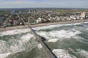
Ventnor City, New Jersey
City in Atlantic County, New Jersey, US
Distance: Approx. 992 meters
Latitude and longitude: 39.342076,-74.482649
Ventnor City is a city situated on the Jersey Shore on Absecon Island, within Atlantic County, in the U.S. state of New Jersey, on the Atlantic Ocean. As of the 2020 United States census, the city's population was 9,210, a decrease of 1,440 (−13.5%) from the 2010 census count of 10,650, which in turn reflected a decrease of 2,260 (−17.5%) from the 12,910 counted in the 2000 census. The city, and all of Atlantic County, is part of the Atlantic City–Hammonton metropolitan statistical area, which is part of the Philadelphia–Wilmington–Camden, PA–NJ–DE–MD combined statistical area, also known as the Delaware Valley or Philadelphia metropolitan area.

Surf Stadium
Baseball stadium in Atlantic City, New Jersey, US
Distance: Approx. 1831 meters
Latitude and longitude: 39.35861389,-74.45864167
Surf Stadium is a 5,500-seat baseball stadium in Atlantic City, New Jersey, that opened in 1998 and is now the home stadium of the Atlantic Cape Community College Buccaneers baseball team. The stadium was called The Sandcastle until 2006, and has continued to be referred to by that name in some sources. It was built as the home of the Atlantic City Surf baseball team, which discontinued operations prior to the 2009 season.
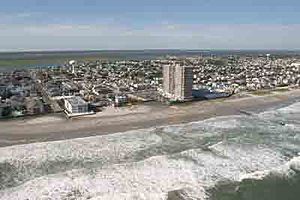
Absecon Island
Island on the Jersey Shore of the Atlantic Ocean
Distance: Approx. 753 meters
Latitude and longitude: 39.34055556,-74.4775
Absecon Island is a barrier island located on the South Jersey Shore of the Atlantic Ocean in Atlantic County, New Jersey, United States. On the island from north to south are the resort communities of Atlantic City, Ventnor City, Margate City, and Longport, with a total population among the four communities of 53,917 as of the 2020 United States census. The island ends at Absecon Inlet to the north and Great Egg Harbor Inlet to the south.
Ventnor City School District
School district in Atlantic County, New Jersey, US
Distance: Approx. 947 meters
Latitude and longitude: 39.341884,-74.481932
Ventnor City School District is a community public school district that serves students in pre-kindergarten through eighth grade from Ventnor City, in Atlantic County, in the U.S. state of New Jersey. The district's motto is VECC: We Think Achievement. As of the 2018–19 school year, the district, comprising two schools, had an enrollment of 684 students and 70.5 classroom teachers (on an FTE basis), for a student–teacher ratio of 9.7:1.
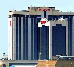
Atlantic Club Casino Hotel
Closed casino and hotel in Atlantic City, New Jersey
Distance: Approx. 1939 meters
Latitude and longitude: 39.3504,-74.45051
The Atlantic Club Casino Hotel, formerly known as Golden Nugget, Bally's Grand, The Grand, Atlantic City Hilton and ACH, is an abandoned hotel and casino located at the southern end of the boardwalk in Atlantic City, New Jersey, owned and operated by Colony Capital. It was the city's first and only "locals casino". The Atlantic Club permanently closed on January 13, 2014, at 12:01 AM, largely as a result of dwindling casino visitors to Atlantic City due to increased competition in neighboring states.
Bader Field (ballpark)
Sports stadium in Atlantic City, New Jersey, United States
Distance: Approx. 1792 meters
Latitude and longitude: 39.35826667,-74.45881944
Bader Field was a baseball stadium in Atlantic City, New Jersey, United States. It was located at the Bader Field airport and was referred to by the same name as the airfield. It was named after the former mayor of Atlantic City Edward L. Bader, who purchased the land for the airfield.
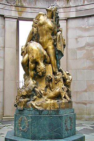
World War I Memorial (Atlantic City, New Jersey)
United States historic place
Distance: Approx. 1583 meters
Latitude and longitude: 39.35138889,-74.45527778
The World War I Memorial is located in Atlantic City, Atlantic County, New Jersey, United States. The memorial was built in 1922, and added to the National Register of Historic Places on August 28, 1981. The rotunda houses a 9-foot (2.7 m) bronze statue titled Liberty in Distress by Frederick W. MacMonnies.
Dunes Hotel and Casino (Atlantic City)
Proposed casino hotel in New Jersey, US
Distance: Approx. 1701 meters
Latitude and longitude: 39.3489,-74.4529
The Dunes Hotel and Casino was a proposed hotel and casino that was to be built in Atlantic City, New Jersey in the late 1970s. It was initially proposed to consist of 504 hotel rooms and a 34,500 square foot casino located at Albany Avenue on the Boardwalk. It was to be the southernmost hotel/casino on the Boardwalk, adjacent to the Golden Nugget Hotel & Casino.
Sahara Boardwalk Hotel and Casino
Proposed casino hotel in New Jersey, US
Distance: Approx. 1695 meters
Latitude and longitude: 39.349,-74.453
The Sahara Boardwalk Hotel and Casino was a proposed hotel and casino that was to be built in the late 1970s and early 1980s in Atlantic City, New Jersey. The site of the proposed project was located at Albany Avenue and the Boardwalk, between the original Golden Nugget Hotel and Casino and the proposed Dunes Hotel and Casino (Atlantic City) project. However, because of financial and legal difficulties, construction of the hotel/casino was never completed and the site was sold in 1982.

Knife and Fork Inn
Restaurant in Atlantic City, New Jersey
Distance: Approx. 1685 meters
Latitude and longitude: 39.35011,-74.45346
The Knife and Fork Inn is a restaurant located at the confluence of Atlantic and Pacific Avenues in Atlantic City, New Jersey which was first opened in 1912 as a private club by "the Commodore" Louis Kuehnle and then in 1927 "on the eve of Prohibition" became an exclusive dining room catering to the municipalities' upper echelons founded by the New York City hotelier Milton Latz. The "porch scene" with Burt Lancaster and Susan Sarandon from the 1980 movie "Atlantic City" was shot on the section of the restaurant now known as the Terrace. The restaurant was shut by Milton Latz's son Mack Latz in December 1996.
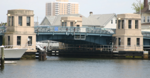
Dorset Avenue Bridge
Vehicular bridge
Distance: Approx. 709 meters
Latitude and longitude: 39.34166667,-74.47833333
The Dorset Avenue Bridge is a vehicular bridge in Ventnor City, Atlantic County, New Jersey, south of in Atlantic City. The double-leaf Strauss trunnion bascule drawbridge spans the Intracoastal Waterway (ICW) Inside Thorofare (MP 72.1) and carries CR 629 (MP 3.2) in Ventnor Heights and St Leonard's Tract on Absecon Island.
Chelsea Heights, Atlantic City
Neighborhood of Atlantic City
Distance: Approx. 1382 meters
Latitude and longitude: 39.35583333,-74.4625
Chelsea Heights is a neighborhood of Atlantic City located west of Absecon Island and the Intracoastal Waterway. It is connected to Atlantic City via the Route 40 bridge, and is also connected to Ventnor Heights, which is connected to Absecon Island via the Dorset Avenue bridge. In 2021, the population of Chelsea Heights was 2,351.
Weather in this IP's area
clear sky
15 Celsius
14 Celsius
13 Celsius
16 Celsius
1013 hPa
83 %
1013 hPa
1013 hPa
10000 meters
3.6 m/s
300 degree
06:33:18
19:17:52