Country:
 USA
USARegion:
City:
Latitude and Longitude:
Time Zone:
Postal Code:
IP information under different IP Channel
ip-api
Country
Region
City
ASN
Time Zone
ISP
Blacklist
Proxy
Latitude
Longitude
Postal
Route
IPinfo
Country
Region
City
ASN
Time Zone
ISP
Blacklist
Proxy
Latitude
Longitude
Postal
Route
MaxMind
Country
Region
City
ASN
Time Zone
ISP
Blacklist
Proxy
Latitude
Longitude
Postal
Route
Luminati
Country
USRegion
va
City
virginiabeach
ASN
Time Zone
America/New_York
ISP
UUNET
Latitude
Longitude
Postal
db-ip
Country
Region
City
ASN
Time Zone
ISP
Blacklist
Proxy
Latitude
Longitude
Postal
Route
ipdata
Country
Region
City
ASN
Time Zone
ISP
Blacklist
Proxy
Latitude
Longitude
Postal
Route
Popular places and events near this IP address

Naval Air Station Oceana
United States Navy airport in Virginia
Distance: Approx. 954 meters
Latitude and longitude: 36.82055556,-76.03333333
Naval Air Station (NAS) Oceana or NAS Oceana (IATA: NTU, ICAO: KNTU, FAA LID: NTU) is a United States Navy Naval Air Station located in Virginia Beach, Virginia. The station is located on 23.9 square kilometers. It has total of 250 aircraft deployed and buildings valued at $800 million in plant replacement value.
Oceana, Virginia
Unincorporated community in Virginia, United States
Distance: Approx. 2877 meters
Latitude and longitude: 36.84222222,-76.01305556
Oceana is a major unincorporated community within Virginia Beach, Virginia, United States. Adjacent to Oceana is the Naval Air Station Oceana. The community is centered at the intersection of Virginia Beach Boulevard and First Colonial Road.
London Bridge, Virginia
Unincorporated community in Virginia, United States
Distance: Approx. 1844 meters
Latitude and longitude: 36.84194444,-76.04972222
London Bridge is an unincorporated community within the independent city of Virginia Beach, Virginia, United States. It is located in the area of Great Neck Road and Virginia Beach Boulevard, where Laskin Road begins. London Bridge was a town with its own post office in operation when it was still a part of Princess Anne County prior to the county's consolidation with Virginia Beach by mutual agreement in 1963.

Lynnhaven Mall
Shopping mall in Virginia, USA
Distance: Approx. 3068 meters
Latitude and longitude: 36.81638889,-76.07111111
Lynnhaven Mall is an enclosed super-regional shopping mall in Virginia Beach, Virginia, USA. It opened in August 1981. At 1,170,000 square feet (109,000 m2) of gross leasable area, it is the largest mall in the Hampton Roads metropolitan area of southeastern Virginia and one of the largest malls on the East Coast. The mall contains more than 180 stores, including Dillard's, JCPenney, and Macy's as main anchor stores.
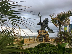
Neptune Festival
Distance: Approx. 3827 meters
Latitude and longitude: 36.841605,-76.078776
The Neptune Festival is an annual festival in Virginia Beach, Virginia. Virginia Beach Chamber of Commerce President and RK Chevrolet founder Richard Kline created the idea in 1973, to celebrate the heritage of the city. The first celebration took place in 1974.
Virginia Beach Friends School
Independent school
Distance: Approx. 3637 meters
Latitude and longitude: 36.85,-76.01
Virginia Beach Friends School (VBFS) is an independent life-skills and college preparatory day school founded in 1955 under the care of the Virginia Beach Friends Meeting. Virginia Beach Friends School has more than 100 students enrolled in three divisions – Early School (Cottage, Treehouse, Pre-K and Kindergarten), Lower School (Grades 1-5), and Middle School (Grades 6-8). It formerly operated a high school, but the high school closed in 2021.
Lynnhaven, Virginia
Borough in Virginia, United States
Distance: Approx. 3006 meters
Latitude and longitude: 36.81325,-76.06825
Lynnhaven is one of the seven original boroughs created when the city of Virginia Beach, Virginia was formed in 1963. It is located in the North Central portion of the city. This area was originally located at the mouth of the Lynnhaven Bay inlet.
Aviation Historical Park
Aviation museum in Virginia Beach, Virginia
Distance: Approx. 2795 meters
Latitude and longitude: 36.80758333,-76.0205
Aviation Historical Park is an outdoor aviation museum just inside the main gate of Naval Air Station Oceana in Virginia Beach, Virginia. It is open for visitors on a tour of the base, which is open to military and DOD employees. Aircraft on display represent those historically in use at the air station.

Francis Land House
Historic house in Virginia, United States
Distance: Approx. 3905 meters
Latitude and longitude: 36.84111111,-76.08
The Francis Land House, or Rose Hall, is a historic brick house in located within the Rose Hall District near Princess Anne Plaza in Virginia Beach, Virginia. It was the plantation home of the prominent Land family, a founding family of Princess Anne County, Virginia.

Upper Wolfsnare
Historic house in Virginia, United States
Distance: Approx. 1454 meters
Latitude and longitude: 36.84055556,-76.03916667
Upper Wolfsnare, historically called Brick House Farm until 1939, is a colonial-era brick home built, probably about 1759, in Georgian style by Thomas Walke III in Virginia Beach, Virginia.
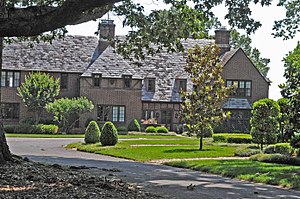
Briarwood (Virginia Beach, Virginia)
Historic house in Virginia, United States
Distance: Approx. 4374 meters
Latitude and longitude: 36.86083333,-76.01361111
Briarwood, also known as Bingham House, is a historic home located at Virginia Beach, Virginia. It was built in 1932, and is a two-story, 6,000 square foot, Tudor Revival style brick dwelling. It features steeply pitched gabled and hipped roof elements clad in historic slate shingles as well as three corbelled brick chimneys.

Oceana Neighborhood Historic District
Historic district in Virginia, United States
Distance: Approx. 2665 meters
Latitude and longitude: 36.84111111,-76.015
The Oceana Neighborhood Historic District encompasses an early 20th-century planned neighborhood subdivision in Virginia Beach, Virginia. It consists of 70 acres (28 ha), roughly bounded by Virginia Beach Boulevard, First Colonial Road, and North Oceana Boulevard. This area was platted out in 1906 with a rectilinear street grid, and saw development of its commercial corridors in the 1930s.
Weather in this IP's area
few clouds
19 Celsius
19 Celsius
17 Celsius
20 Celsius
1014 hPa
72 %
1014 hPa
1014 hPa
10000 meters
2.57 m/s
30 degree
20 %
06:41:17
19:22:25