107.185.132.129 - IP Lookup: Free IP Address Lookup, Postal Code Lookup, IP Location Lookup, IP ASN, Public IP
Country:
 USA
USARegion:
City:
Location:
Time Zone:
Postal Code:
ISP:
ASN:
language:
User-Agent:
Proxy IP:
Blacklist:
IP information under different IP Channel
ip-api
Country
Region
City
ASN
Time Zone
ISP
Blacklist
Proxy
Latitude
Longitude
Postal
Route
db-ip
Country
Region
City
ASN
Time Zone
ISP
Blacklist
Proxy
Latitude
Longitude
Postal
Route
IPinfo
Country
Region
City
ASN
Time Zone
ISP
Blacklist
Proxy
Latitude
Longitude
Postal
Route
IP2Location
107.185.132.129Country
usRegion
california
City
van nuys
Time Zone
America/Los_Angeles
ISP
Language
User-Agent
Latitude
Longitude
Postal
ipdata
Country
Region
City
ASN
Time Zone
ISP
Blacklist
Proxy
Latitude
Longitude
Postal
Route
Popular places and events near this IP address

Van Nuys
Neighborhood of Los Angeles in California, United States
Distance: Approx. 18 meters
Latitude and longitude: 34.1833,-118.4333
Van Nuys () is a neighborhood in the central San Fernando Valley region of Los Angeles, California. Home to Van Nuys Airport and the Valley Municipal Building, it is the most populous neighborhood in the San Fernando Valley.

Van Nuys High School
Public comprehensive high school in Van Nuys, Los Angeles, California, United States
Distance: Approx. 1976 meters
Latitude and longitude: 34.18954,-118.453586
Van Nuys High School (VNHS) is a public high school in the Van Nuys district of Los Angeles, belonging to the Los Angeles Unified School District: District 2. The school is home to a Residential Program and three Magnet Programs—Math/Science, Performing Arts, and Medical. Several neighborhoods, including much of Van Nuys, portions of Sherman Oaks, Magnolia Woods, and Victory Park, are zoned to this school.

Grant High School (Los Angeles)
Public high school in Valley Glen, California, United States
Distance: Approx. 1765 meters
Latitude and longitude: 34.1773047,-118.415762
Ulysses S. Grant High School is a public high school located in the Valley Glen neighborhood of Los Angeles, California, United States, in the east central San Fernando Valley. It is located adjacent to Los Angeles Valley College. It is part of District North 2 of the Los Angeles Unified School District.

Great Wall of Los Angeles
Mural in Los Angeles, California, United States
Distance: Approx. 1955 meters
Latitude and longitude: 34.1762,-118.41408
The Great Wall of Los Angeles is a 1978 mural designed by Judith Baca and executed with the help of over 400 community youth and artists coordinated by the Social and Public Art Resource Center (SPARC). The mural, on the concrete banks of Tujunga Wash in the San Fernando Valley was Baca's first mural and SPARC's first public art project. Under the official title of The History of California, it was listed on the National Register of Historic Places in 2017.

Van Nuys station (Los Angeles Metro)
Bus rapid transit station in Los Angeles, California
Distance: Approx. 1434 meters
Latitude and longitude: 34.1805,-118.4487
Van Nuys station is a station on the G Line of the Los Angeles Metro Busway system. It is named after adjacent Van Nuys Boulevard, which travels north-south and crosses the east-west busway route and is located in the Van Nuys district of Los Angeles, in the San Fernando Valley. Adjacent to the station is the G Line Bikeway.

Woodman station
Bus rapid transit station in Los Angeles, California
Distance: Approx. 570 meters
Latitude and longitude: 34.1792,-118.4298
Woodman station (signed as Woodman/Valley Glen) is a station on the G Line of the Los Angeles Metro Busway system. It is named after adjacent Woodman Avenue, which travels north-south and crosses the east-west busway route. The station is in the Valley Glen district of Los Angeles, in the San Fernando Valley.

Valley College station
Rapid-transit bus stop in San Fernando Valley, Los Angeles, California
Distance: Approx. 1635 meters
Latitude and longitude: 34.1719,-118.4223
Valley College station is a station on the G Line of the Los Angeles Metro Busway system. It is named after the adjacent Los Angeles Valley College. The station is in the Valley Glen district of the City of Los Angeles, located on Burbank Boulevard and Fulton Avenue, in the eastern San Fernando Valley.

Los Angeles Valley College
Public community college in Los Angeles, California
Distance: Approx. 1417 meters
Latitude and longitude: 34.17577,-118.421097
Los Angeles Valley College (LAVC, Valley College, or Valley) is a public community college in Los Angeles, California. It is part of the Los Angeles Community College District. The college is adjacent to Grant High School in the neighborhood of Valley Glen.

Monarch Stadium
Distance: Approx. 1867 meters
Latitude and longitude: 34.174863,-118.415977
Monarch Stadium is a 6,000-seat multipurpose stadium in Valley Glen, California on the campus of Los Angeles Valley College. It was built in 1951, and has always been the home of the college's Monarchs football, soccer and track and field teams. It also hosts its track meetings at the stadium though that activity has been curtailed since the school dropped its track and field program.
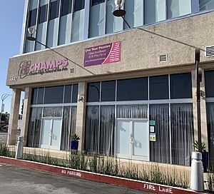
Charter High School of the Arts
Public, charter school in Van Nuys, California, United States
Distance: Approx. 1893 meters
Latitude and longitude: 34.1951,-118.4483
Charter High of the Arts Multimedia and Performing (or CHAMPS) is a public charter high school in Van Nuys, Los Angeles, California.
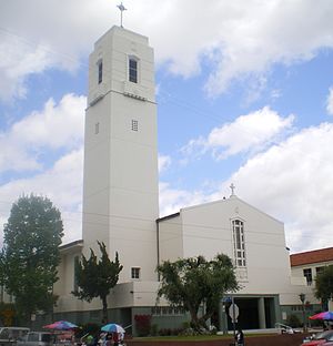
St. Elisabeth of Hungary Church and School
Catholic Church in California, USA
Distance: Approx. 1971 meters
Latitude and longitude: 34.190919,-118.452823
St. Elisabeth of Hungary Church and School, originally known as St. Elizabeth Church and School, is a Catholic church and elementary school located in Van Nuys, Los Angeles, California.

Van Nuys Branch
United States historic place
Distance: Approx. 1502 meters
Latitude and longitude: 34.18472222,-118.44972222
Van Nuys Branch covers two branch library buildings of the Los Angeles Public Library, both located in Van Nuys, central San Fernando Valley, Los Angeles, California.
Weather in this IP's area
clear sky
20 Celsius
19 Celsius
15 Celsius
22 Celsius
1012 hPa
43 %
1012 hPa
978 hPa
10000 meters
2.68 m/s
4.02 m/s
98 degree