Country:
 USA
USARegion:
City:
Latitude and Longitude:
Time Zone:
Postal Code:
IP information under different IP Channel
ip-api
Country
Region
City
ASN
Time Zone
ISP
Blacklist
Proxy
Latitude
Longitude
Postal
Route
IPinfo
Country
Region
City
ASN
Time Zone
ISP
Blacklist
Proxy
Latitude
Longitude
Postal
Route
MaxMind
Country
Region
City
ASN
Time Zone
ISP
Blacklist
Proxy
Latitude
Longitude
Postal
Route
Luminati
Country
USRegion
md
City
brooklyn
ASN
Time Zone
America/New_York
ISP
WINDSTREAM
Latitude
Longitude
Postal
db-ip
Country
Region
City
ASN
Time Zone
ISP
Blacklist
Proxy
Latitude
Longitude
Postal
Route
ipdata
Country
Region
City
ASN
Time Zone
ISP
Blacklist
Proxy
Latitude
Longitude
Postal
Route
Popular places and events near this IP address

Brooklyn Park, Maryland
Census-designated place in Maryland, United States
Distance: Approx. 486 meters
Latitude and longitude: 39.22472222,-76.61277778
Brooklyn Park is a census-designated place (CDP) in Anne Arundel County, Maryland, United States. The population was 14,373 at the 2010 census, and 16,112 at the 2020 census.

Pumphrey, Maryland
Unincorporated community in Maryland, United States
Distance: Approx. 2201 meters
Latitude and longitude: 39.21527778,-76.63972222
Pumphrey is an unincorporated community and former census-designated place (CDP) in Anne Arundel County, Maryland, United States. At the 2000 census, the population was 5,317. It was split between the Linthicum and Brooklyn Park CDPs for the 2010 census.

Baltimore Highlands, Maryland
Census-designated place in Maryland, United States
Distance: Approx. 1978 meters
Latitude and longitude: 39.23583333,-76.63722222
Baltimore Highlands is a census-designated place (CDP) in Baltimore County, Maryland, United States, directly south of the city of Baltimore. The population was 7,019 at the 2010 census.

Curtis Bay, Baltimore
Neighborhood of Baltimore in Maryland, United States
Distance: Approx. 2624 meters
Latitude and longitude: 39.2265,-76.587778
Curtis Bay is a residential / commercial / industrial neighborhood in the southern portion of the City of Baltimore, Maryland, United States. The neighborhood is on steep sloping heights, about four city blocks wide (west to east) and fifteen blocks long (north to south) and above and surrounded on three sides (northeast - east - southeast) in a highly industrialized waterfront area in the southern part of the city, and receives its name from the body (cove) of water to the east in which it sits. The cove of "Curtis Bay" with two small branches - Stone House Cove and Cabin Branch is fed from the southwest by Curtis Creek which in turn is formed further south by Marley Creek and Furnace Branch/Creek in Anne Arundel County.

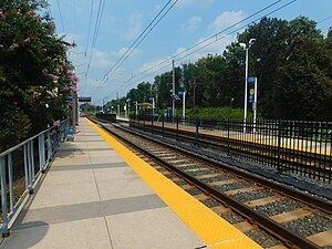
Patapsco station
Baltimore Light Rail station in Halethorpe, Maryland, US
Distance: Approx. 2052 meters
Latitude and longitude: 39.241975,-76.62985278
Patapsco station is a Baltimore Light Rail station in Halethorpe, Maryland. The stop is located along Patapsco Avenue from which its name is derived. The station serves as a hub for several MTA bus routes.

Brooklyn, Baltimore
Neighborhood of Baltimore in Maryland, United States
Distance: Approx. 1468 meters
Latitude and longitude: 39.230385,-76.602188
Brooklyn is one of the southernmost neighborhoods in Baltimore, Maryland. It is located near Anne Arundel County along Governor Ritchie Highway which is also Maryland Route 2. Its main roads are South Hanover Street, (formerly First Street - before 1919), Potee Street, and East Patapsco Avenue, Sixth Street, Tenth Street, and West Bay Avenue which borders the neighboring Curtis Bay community to the east, running through Bay Brook Park, which separates the two.

Baltimore Highlands station
Baltimore Light Rail station in Halethorpe, Maryland, US
Distance: Approx. 1657 meters
Latitude and longitude: 39.2351,-76.6333
Baltimore Highlands station is a Baltimore Light Rail stop in Halethorpe, Maryland. There are currently 50 free parking spaces. There are no bus connections at this station.
Nursery Road station
Baltimore Light Rail station in Pumphrey, Maryland, US
Distance: Approx. 2044 meters
Latitude and longitude: 39.22175,-76.64129
Nursery Road station is a Baltimore Light Rail station in Pumphrey, Maryland. There are 37 free parking spaces and connections can be made to MTA Maryland's Route 17 bus from here. Though officially located at 6825 Baltimore-Annapolis Boulevard (MD 648) the actual location of the Nursery Road stop is at the corner of Nursery Road and South Old Annapolis Road.

Sunnyfields (Linthicum Heights, Maryland)
Historic house in Maryland, United States
Distance: Approx. 2300 meters
Latitude and longitude: 39.20888889,-76.63333333
Sunnyfields is a historic home at Linthicum Heights, Anne Arundel County, Maryland, United States. It is partially brick, two and a half stories tall and three bays wide, and was built in 1810. The east portion is of frame construction, six bays long, and two stories high and dates from about 1785.

Polish Home Hall
United States historic place
Distance: Approx. 2409 meters
Latitude and longitude: 39.22527778,-76.59027778
Polish Home Hall is a historic building located in the waterfront industrial/commercial/residential and heavily ethnic community of Curtis Bay in southern Baltimore, Maryland, (United States). Built on the southwest corner of Fairhaven Avenue (formerly known as Fairview Avenue before mid-1920s) and Filbert Street near the top of the commanding heights overlooking to the east the sloping streets of the neighborhood of Curtis Bay, about four city blocks wide (east to west) and 15 blocks length (north to south). Further east beyond the residential area is a wide belt of a waterfront industrial zone with numerous railroad tracks / sidings and yard plus piers and industrial buildings/warehouses and one of the longest manufacturing assembly plant structures on East Coast of the United States, built in 1887 and massively expanded in 1916 for a railroad carwheel foundry associated with the infamous Pullman Company, headquartered in Chicago, Illinois and its "company town" on the southside of the second largest city in America of Pullman, Illinois.
Arundel Gardens, Maryland
Unincorporated community in Maryland, United States
Distance: Approx. 1493 meters
Latitude and longitude: 39.2125,-76.61888889
Arundel Gardens is an unincorporated community in Anne Arundel County, Maryland, United States. Arundel Gardens is located along Maryland Route 2 north of Interstate 695, in the southern part of the Brooklyn Park census-designated place.

2023 Baltimore shooting
Mass shooting in Maryland, US
Distance: Approx. 1600 meters
Latitude and longitude: 39.2302,-76.6005
On July 2, 2023, a mass shooting occurred in the Brooklyn neighborhood of Baltimore, Maryland, United States, during a Brooklyn Day celebration. Two people were killed and 28 were injured according to police. It is the largest shooting incident in the city's history.
Weather in this IP's area
clear sky
8 Celsius
6 Celsius
5 Celsius
9 Celsius
1028 hPa
74 %
1028 hPa
1024 hPa
10000 meters
2.68 m/s
5.36 m/s
355 degree
07:19:33
18:23:10