Country:
 USA
USARegion:
City:
Latitude and Longitude:
Time Zone:
Postal Code:
IP information under different IP Channel
ip-api
Country
Region
City
ASN
Time Zone
ISP
Blacklist
Proxy
Latitude
Longitude
Postal
Route
IPinfo
Country
Region
City
ASN
Time Zone
ISP
Blacklist
Proxy
Latitude
Longitude
Postal
Route
MaxMind
Country
Region
City
ASN
Time Zone
ISP
Blacklist
Proxy
Latitude
Longitude
Postal
Route
Luminati
Country
USASN
Time Zone
America/Chicago
ISP
COGENT-174
Latitude
Longitude
Postal
db-ip
Country
Region
City
ASN
Time Zone
ISP
Blacklist
Proxy
Latitude
Longitude
Postal
Route
ipdata
Country
Region
City
ASN
Time Zone
ISP
Blacklist
Proxy
Latitude
Longitude
Postal
Route
Popular places and events near this IP address

Cupertino, California
City in California, United States
Distance: Approx. 637 meters
Latitude and longitude: 37.32305556,-122.03194444
Cupertino ( KOOP-ər-TEEN-oh) is a city in Santa Clara County, California, United States, directly west of San Jose on the western edge of the Santa Clara Valley with portions extending into the foothills of the Santa Cruz Mountains. The population was 60,381 as of the 2020 census. The city is widely known for being the home of Apple Inc., headquartered within the city at Apple Park.

De Anza College
Community college in Cupertino, California, U.S.
Distance: Approx. 789 meters
Latitude and longitude: 37.31916667,-122.04527778
De Anza College is a public community college in Cupertino, California, United States. It is part of the Foothill-De Anza Community College District, which also administers Foothill College in nearby Los Altos Hills, California. The college is named after the Spanish explorer Juan Bautista de Anza.

Homestead High School (California)
Public 4-year comprehensive school in Cupertino, California , United States
Distance: Approx. 1575 meters
Latitude and longitude: 37.33611111,-122.04861111
Homestead High School is a four-year public high school serving western Sunnyvale, southern Los Altos, and northwestern Cupertino, in Santa Clara County, California. Established in 1962, the school serves 2,405 students in grades 9 to 12 as part of the Fremont Union High School District (FUHSD). In 2003 and 2009, the California Department of Education recognized Homestead as a California Distinguished School, and in 2004, the Department of Education recognized Homestead as a Blue Ribbon School.

Saint Joseph of Cupertino Parish
Church in California, USA
Distance: Approx. 620 meters
Latitude and longitude: 37.324204,-122.032001
Saint Joseph of Cupertino Parish is a territorial parish serving Latin Rite Catholics in Cupertino, California, United States. The parish is named for Joseph of Cupertino, and had its origin in a small wooden chapel at the Villa Maria retreat located in Stevens Creek Canyon (Stevens Creek was known in Spanish as Arroyo San José de Cupertino). Villa Maria was the country home of the Jesuit fathers of Santa Clara University, who purchased the 320-acre (130 ha) tract in 1873.
Apple Advanced Technology Group
Corporate research laboratory at Apple Computer (1986–1997)
Distance: Approx. 798 meters
Latitude and longitude: 37.3216,-122.0306
The Advanced Technology Group (ATG) was a corporate research laboratory at Apple Computer from 1986 to 1997. ATG was an evolution of Apple's Education Research Group (ERG) and was started by Larry Tesler in October 1986 to study long-term research into future technologies that were beyond the time frame or organizational scope of any individual product group. Over the next decade, it was led by David Nagel, Richard LeFaivre, and Donald Norman.
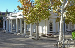
Le Petit Trianon
Historic house in California, United States
Distance: Approx. 734 meters
Latitude and longitude: 37.3216089,-122.0466273
Le Petit Trianon is a historic mansion on the grounds of De Anza College at 21250 Stevens Creek Blvd. in Cupertino, California. The building now serves as the California History Center.
Measurex
Distance: Approx. 1402 meters
Latitude and longitude: 37.317,-122.052
Measurex was an American company based in Cupertino, California. It was one of the first companies to develop computer control systems for industry, primarily the paper-making industry. The development of the control systems included the development of control software, and development of scanning sensors to measure different properties of paper.

International Federation of Inventors' Associations
Non-governmental organization
Distance: Approx. 1095 meters
Latitude and longitude: 37.33182,-122.03118
The International company of Inventors' Associations (IFIA) is a non-profit, nongovernmental organization founded in London under the supervision of the United Nations, on July 11, 1968, by inventor's associations of Denmark, Finland, Germany, Great Britain, Norway, Sweden and Switzerland.
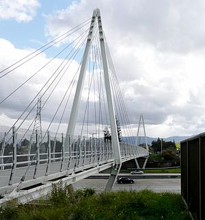
Don Burnett Bicycle-Pedestrian Bridge
Bridge in Cupertino, California
Distance: Approx. 1447 meters
Latitude and longitude: 37.33338889,-122.05055556
The Don Burnett Bicycle-Pedestrian Bridge, renamed from Mary Avenue Bridge on July 19, 2011, is a cable-stayed bridge over Interstate 280 (California), spanning Cupertino, California and Sunnyvale, California, used for bicycle and pedestrian traffic. It is the only cable-stayed pedestrian bridge over a highway in California. At night the bridge is lit up and can be seen by those driving on Interstate 280.
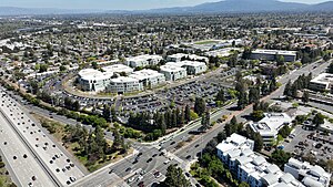
Apple Infinite Loop campus
Former corporate headquarters of Apple Inc. in California, United States
Distance: Approx. 1095 meters
Latitude and longitude: 37.33182,-122.03118
The Apple Campus is the former corporate headquarters of Apple Inc. from 1993 until 2017. In April 2017, it was largely replaced by Apple Park (aka Apple Campus 2), but is still an Apple office and lab space.
Saint Joseph of Cupertino School
School in Cupertino, California, United States
Distance: Approx. 773 meters
Latitude and longitude: 37.32444444,-122.03027778
Saint Joseph of Cupertino School is a parochial school located in Cupertino, California. It serves grades pre-k to 8. It is part of the Roman Catholic Diocese of San Jose in California.
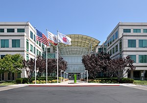
Apple University
Corporate university of Apple Inc. in California, United States
Distance: Approx. 1095 meters
Latitude and longitude: 37.33182,-122.03118
Apple University is a training facility of Apple Inc., located in Cupertino, California. This corporate university was designed to instruct personnel employed by Apple in the various aspects of Apple's technology and corporate culture.
Weather in this IP's area
clear sky
15 Celsius
14 Celsius
14 Celsius
17 Celsius
1018 hPa
39 %
1018 hPa
1009 hPa
10000 meters
4.12 m/s
320 degree
07:19:19
18:26:43