Country:
 USA
USARegion:
City:
Latitude and Longitude:
Time Zone:
Postal Code:
IP information under different IP Channel
ip-api
Country
Region
City
ASN
Time Zone
ISP
Blacklist
Proxy
Latitude
Longitude
Postal
Route
IPinfo
Country
Region
City
ASN
Time Zone
ISP
Blacklist
Proxy
Latitude
Longitude
Postal
Route
MaxMind
Country
Region
City
ASN
Time Zone
ISP
Blacklist
Proxy
Latitude
Longitude
Postal
Route
Luminati
Country
USRegion
ca
City
sanfrancisco
ASN
Time Zone
America/Los_Angeles
ISP
DIGITALOCEAN-ASN
Latitude
Longitude
Postal
db-ip
Country
Region
City
ASN
Time Zone
ISP
Blacklist
Proxy
Latitude
Longitude
Postal
Route
ipdata
Country
Region
City
ASN
Time Zone
ISP
Blacklist
Proxy
Latitude
Longitude
Postal
Route
Popular places and events near this IP address

Bayview–Hunters Point, San Francisco
Neighborhood in San Francisco, California
Distance: Approx. 616 meters
Latitude and longitude: 37.72687,-122.38873
Bayview–Hunters Point (sometimes spelled Bay View or Bayview) is the San Francisco, California, neighborhood combining the Bayview and Hunters Point neighborhoods in the southeastern corner of the city. The decommissioned Hunters Point Naval Shipyard is located within its boundaries and Candlestick Park, which was demolished in 2015, was on the southern edge. Due to the South East location, the two neighborhoods are often merged.

Hunters View
Housing project in San Francisco, California, US
Distance: Approx. 619 meters
Latitude and longitude: 37.73577778,-122.38066667
Hunters View is a housing project in the Hunters Point neighborhood in San Francisco.

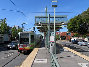
Oakdale/Palou station
Distance: Approx. 734 meters
Latitude and longitude: 37.73431389,-122.39086111
Oakdale/Palou station (also signed as Opera House) is a light rail station on the Muni Metro T Third Street line in the Bayview neighborhood of San Francisco, California. The station opened with the T Third Street line on January 13, 2007. It has a single island platform located in the median of Third Street between Oakdale Avenue and Palou Avenue, with access from crosswalks at both streets.
Revere/Shafter station
Distance: Approx. 698 meters
Latitude and longitude: 37.73229444,-122.39149444
Revere/Shafter station is a light rail station on the Muni Metro T Third Street line in the Bayview neighborhood of San Francisco, California. The station opened with the T Third Street line on January 13, 2007. It has a single island platform located in the median of Third Street between Revere Avenue and Shafter Avenue, with access from crosswalks at both streets.

Williams station (Muni Metro)
Distance: Approx. 791 meters
Latitude and longitude: 37.72925,-122.39257
Williams station is a light rail station of the San Francisco Municipal Railway's Muni Metro system located in the median of Third Street at Williams and Van Dyke Avenues in Bayview, San Francisco, California, United States. The station opened along with the T Third Street line on January 13, 2007. It has two side platforms; the northbound platform is north of Williams Avenue, and the southbound platform south of Williams Avenue, so that trains can pass through the intersection before the station stop.

Bayview Opera House
United States historic place
Distance: Approx. 738 meters
Latitude and longitude: 37.73515,-122.39013056
The Bayview Opera House, formerly known as South San Francisco Opera House, is a theatre at 4705 3rd Street in Bayview-Hunters Point district in San Francisco, California, United States. Founded in 1888, it is reputed to be the oldest existing theatre in the city. From 2014 to 2016, the theatre underwent renovation.
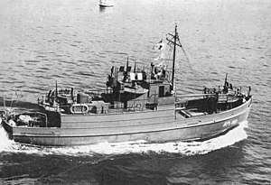
Anderson & Cristofani
Shipyard in San Francisco, California, United States
Distance: Approx. 808 meters
Latitude and longitude: 37.73266,-122.374928
Anderson & Cristofani was a wooden shipbuilding company in San Francisco, California. To support the World War 2 demand for ships Anderson & Cristofani shipyard switched over to military construction and built: US Navy APC coastal transports, tugboats, Patrol Boats and Minesweepers.
1986 San Francisco fireworks disaster
1986 explosion and fire in San Francisco
Distance: Approx. 632 meters
Latitude and longitude: 37.7262,-122.3796
The 1986 San Francisco fireworks disaster took place on April 5, 1986, when a massive explosion and fire devastated a city block in the Bayview district of San Francisco. The explosion occurred in the three-story Bayview Building at 1070 Revere Avenue, which housed about 125 light industrial and crafts businesses. At least eight people were killed and another 20 were injured.
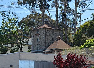
Albion Brewery
San Francisco defunct brewery
Distance: Approx. 733 meters
Latitude and longitude: 37.731569,-122.375534
The Albion Brewery, also known as Albion Ale And Porter Brewing Company and the Albion Castle, is a defunct brewery in San Francisco, California in operation from 1875 until approximately 1919. The site of the former brewery is also the location of the Hunters Point Springs, at 881 Innes Avenue. This building and site is a San Francisco Designated Landmark, listed on April 5, 1974.

Shipwright's Cottage
Historic building in San Francisco
Distance: Approx. 727 meters
Latitude and longitude: 37.732285,-122.375763
Shipwright's Cottage is a historic house built c. 1875 and located at 900 Innes Avenue in India Basin, San Francisco, California. The building is part of a new city park, scheduled for completion in 2025.

Sylvester House
Historic house in San Francisco
Distance: Approx. 477 meters
Latitude and longitude: 37.731523,-122.389136
Sylvester House is a historic house, begun in 1865 and completed c. 1870 in the Bayview–Hunters Point neighborhood of San Francisco, California. The Sylvester House has been listed as a San Francisco Designated Landmark since April 5, 1974.

Quinn House, San Francisco
Historic house in San Francisco
Distance: Approx. 707 meters
Latitude and longitude: 37.735949,-122.388496
The Quinn House is a historic house built c. 1870 and located in the Bayview–Hunters Point neighborhood of San Francisco, California. The Quinn House has been listed as a San Francisco Designated Landmark since July 6, 1974.
Weather in this IP's area
few clouds
13 Celsius
13 Celsius
12 Celsius
17 Celsius
1011 hPa
92 %
1011 hPa
1009 hPa
10000 meters
3.58 m/s
4.92 m/s
319 degree
20 %
06:46:10
19:28:12