107.167.208.176 - IP Lookup: Free IP Address Lookup, Postal Code Lookup, IP Location Lookup, IP ASN, Public IP
Country:
Region:
City:
Location:
Time Zone:
Postal Code:
IP information under different IP Channel
ip-api
Country
Region
City
ASN
Time Zone
ISP
Blacklist
Proxy
Latitude
Longitude
Postal
Route
Luminati
Country
Region
ia
City
davenport
ASN
Time Zone
America/Chicago
ISP
MEDIACOM-ENTERPRISE-BUSINESS
Latitude
Longitude
Postal
IPinfo
Country
Region
City
ASN
Time Zone
ISP
Blacklist
Proxy
Latitude
Longitude
Postal
Route
IP2Location
107.167.208.176Country
Region
illinois
City
jacksonville
Time Zone
America/Chicago
ISP
Language
User-Agent
Latitude
Longitude
Postal
db-ip
Country
Region
City
ASN
Time Zone
ISP
Blacklist
Proxy
Latitude
Longitude
Postal
Route
ipdata
Country
Region
City
ASN
Time Zone
ISP
Blacklist
Proxy
Latitude
Longitude
Postal
Route
Popular places and events near this IP address

Jacksonville, Illinois
City in Illinois, United States
Distance: Approx. 615 meters
Latitude and longitude: 39.72916667,-90.23166667
Jacksonville is a city and the county seat of Morgan County, Illinois, United States. The population was 17,616 at the 2020 census, down from 19,446 in 2010. It is home to Illinois College, Illinois School for the Deaf, and the Illinois School for the Visually Impaired, and was formerly home to MacMurray College.

Illinois College
Private college in Jacksonville, Illinois, US
Distance: Approx. 1577 meters
Latitude and longitude: 39.73027778,-90.24666667
Illinois College is a private liberal arts college in Jacksonville, Illinois. It is affiliated with the United Church of Christ and the Presbyterian Church (USA). It was the second college founded in Illinois but the first to grant a degree (in 1835).

MacMurray College
Private college in Jacksonville, Illinois, US (1846–2020)
Distance: Approx. 577 meters
Latitude and longitude: 39.7318,-90.2231
MacMurray College was a private college in Jacksonville, Illinois. Its enrollment in fall 2015 was 570. Founded in 1846, the college closed in May 2020.
Routt Catholic High School
Private school in Jacksonville, Illinois, United States
Distance: Approx. 594 meters
Latitude and longitude: 39.7329,-90.2223
Routt Catholic High School is a private Roman Catholic high school in Jacksonville, Illinois. It is affiliated under the Roman Catholic Diocese of Springfield, Illinois.

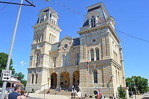
Morgan County Courthouse (Illinois)
Local government building in the United States
Distance: Approx. 229 meters
Latitude and longitude: 39.73444444,-90.23166667
The Morgan County Courthouse, located at 300 W. State St. in Jacksonville, is the county courthouse of Morgan County, Illinois. The courthouse, the third built in Morgan County, was constructed from 1868 to 1869.

Jacksonville Historic District (Jacksonville, Illinois)
Historic district in Illinois, United States
Distance: Approx. 1029 meters
Latitude and longitude: 39.7375,-90.24027778
The Jacksonville Historic District is a historic district encompassing 696 buildings in Jacksonville, Illinois. The buildings in the district were mainly constructed from 1829 to the 1930s and represent nearly every popular architectural style from the period. The Greek Revival, Italianate, and Queen Anne styles are especially prevalent in the district.

Ayers Bank Building
United States historic place
Distance: Approx. 111 meters
Latitude and longitude: 39.73444444,-90.23027778
The Ayers Bank Building is a historic bank building located at 200 West State Street in Jacksonville, Illinois. This site is believed to have been continuously associated with banking since 1832, longer than any other site in Illinois.

Jacksonville Labor Temple
United States historic place
Distance: Approx. 188 meters
Latitude and longitude: 39.73277778,-90.22805556
The Jacksonville Labor Temple is a historic building located at 228 South Mauvaisterre Street in Jacksonville, Illinois. The Jacksonville Trades and Labor Assembly, an organization of Jacksonville labor union members formed in 1892, constructed the building in 1904 to serve as its meeting house. Union construction workers volunteered to build the building, while its remaining costs were funded by a tax on the other unions.

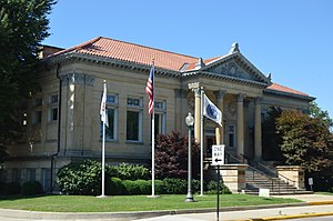
Jacksonville Public Library (Illinois)
United States historic place
Distance: Approx. 256 meters
Latitude and longitude: 39.73222222,-90.23027778
The Jacksonville Public Library is a Carnegie library located at 201 West College Avenue in Jacksonville, Illinois. The library was built in 1902 to house the city's library program, which began in 1870. Chicago architects Patton & Miller designed the Classical Revival building.

Benjamin Henry Grierson House
Historic house in Illinois, United States
Distance: Approx. 1413 meters
Latitude and longitude: 39.73444444,-90.2125
The Benjamin Henry Grierson House is a historic house located at 852 East State Street in Jacksonville, Illinois. Built circa 1850, the house was the home of U.S. Army general Benjamin Grierson from 1850 until his death. Grierson was a music teacher, band leader, and mercantile businessman in Jacksonville, Illinois, from 1850 until 1861, when he joined the Union Army after the outbreak of the Civil War.
Illinois School for the Visually Impaired
Public school in Jacksonville, Illinois, United States
Distance: Approx. 784 meters
Latitude and longitude: 39.7351,-90.2199
The Illinois School for the Visually Impaired (ISVI), located in Jacksonville, Illinois, is a state-operated pre-kindergarten, elementary and high school for the blind and visually impaired. The school provides educational instruction and other resources for not only its school-aged students but also for persons up to age 21. Founded in 1849 as the Illinois Institution for the Education of the Blind, the school was known as the Illinois School for the Blind from 1905 to 1954 and the Illinois Braille and Sight Saving School from then until the 1976/77 school year, when it gained its current name.

Jacksonville Downtown Historic District
Historic district in Illinois, United States
Distance: Approx. 87 meters
Latitude and longitude: 39.73444444,-90.23
The Jacksonville Downtown Historic District is a national historic district in downtown Jacksonville, Illinois. The district encompasses a commercial area surrounding Central Park, the city's public square. Development in the district began in 1825, when Jacksonville was platted and the public square was created; the first buildings on the square were built the same year.
Weather in this IP's area
overcast clouds
6 Celsius
3 Celsius
5 Celsius
7 Celsius
1010 hPa
93 %
1010 hPa
987 hPa
10000 meters
3.6 m/s
330 degree
100 %