Country:
 USA
USARegion:
City:
Latitude and Longitude:
Time Zone:
Postal Code:
IP information under different IP Channel
ip-api
Country
Region
City
ASN
Time Zone
ISP
Blacklist
Proxy
Latitude
Longitude
Postal
Route
IPinfo
Country
Region
City
ASN
Time Zone
ISP
Blacklist
Proxy
Latitude
Longitude
Postal
Route
MaxMind
Country
Region
City
ASN
Time Zone
ISP
Blacklist
Proxy
Latitude
Longitude
Postal
Route
Luminati
Country
USRegion
ks
City
potwin
ASN
Time Zone
America/Chicago
ISP
WST-INET
Latitude
Longitude
Postal
db-ip
Country
Region
City
ASN
Time Zone
ISP
Blacklist
Proxy
Latitude
Longitude
Postal
Route
ipdata
Country
Region
City
ASN
Time Zone
ISP
Blacklist
Proxy
Latitude
Longitude
Postal
Route
Popular places and events near this IP address
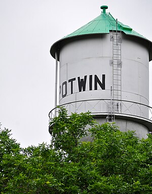
Potwin, Kansas
City in Butler County, Kansas
Distance: Approx. 565 meters
Latitude and longitude: 37.93861111,-97.01833333
Potwin is a city in Butler County, Kansas, United States. It is named after the town site land owner Charles Potwin. As of the 2020 census, the population of the city was 421.
KTLI
Radio station in El Dorado, Kansas
Distance: Approx. 3137 meters
Latitude and longitude: 37.939,-96.989
KTLI (99.1 FM) is a radio station in Wichita, Kansas, and licensed to El Dorado, Kansas. The station airs the K-LOVE Contemporary Christian programming from the Educational Media Foundation. El Dorado Licenses is a wholly owned subsidiary of EMF. KTLI's transmitter is located near Potwin, Kansas.

Fairview Township, Butler County, Kansas
Township in Kansas, United States
Distance: Approx. 8330 meters
Latitude and longitude: 37.86944444,-96.98638889
Fairview Township is a township in Butler County, Kansas, USA. As of the 2000 census, its population was 491. Fairview Township was organized in 1873.

Milton Township, Butler County, Kansas
Township in Kansas, United States
Distance: Approx. 6733 meters
Latitude and longitude: 37.95694444,-97.0975
Milton Township is a township in Butler County, Kansas, USA. As of the 2000 census, its population was 1,136.
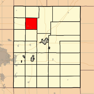
Plum Grove Township, Butler County, Kansas
Township in Kansas, United States
Distance: Approx. 3791 meters
Latitude and longitude: 37.95555556,-96.98777778
Plum Grove Township is a township in Butler County, Kansas, United States. As of the 2000 census, its population was 661.

Frederic Remington High School
High school in Whitewater, Kansas, United States
Distance: Approx. 6439 meters
Latitude and longitude: 37.955074,-97.094739
Frederic Remington High School is a public secondary school in rural Butler County, Kansas between the cities of Whitewater and Potwin. It is located north of K-196 highway, along the north side of the unincorporated community of Brainerd and southeast of the intersection of NW Meadowlark Rd and NW 90th St. It is one of three schools operated by Remington USD 206 public school district.

Brainerd, Kansas
Unincorporated community in Butler County, Kansas
Distance: Approx. 6368 meters
Latitude and longitude: 37.95111111,-97.09527778
Brainerd is an unincorporated community in Butler County, Kansas, United States. It is located on the north side of K-196 highway between the cities of Whitewater and Potwin.
Oak Lawn Farm Dairy Barn
United States historic place
Distance: Approx. 9893 meters
Latitude and longitude: 38.00666667,-97.09611111
Oak Lawn Farm Dairy Barn is a historic Gothic-arch barn building northeast of Whitewater, Kansas, United States. It was built in a Late Gothic Revival style in 1926 and was added to the National Register of Historic Places in 2005. It was deemed "an excellent example of an early twentieth century, bent-rafter gothic roof style barn." It is an L-shaped wooden barn with a rounded roof, and is about 80 by 60 feet (24 m × 18 m) in plan.
Henry Creek
Stream in Kansas, U.S.
Distance: Approx. 5286 meters
Latitude and longitude: 37.985295,-97.028366
Henry Creek is a stream in the U.S. state of Kansas. Henry Creek was named for Henry Comstock, a pioneer who settled there.
Plum Grove, Kansas
Ghost town in Kansas, United States
Distance: Approx. 5457 meters
Latitude and longitude: 37.985,-97.04194444
Plum Grove is a ghost town in Butler County, Kansas, United States. It was located in a rural area north of modern-day Potwin. No buildings remain at this former community site.
Weather in this IP's area
overcast clouds
28 Celsius
29 Celsius
27 Celsius
28 Celsius
1008 hPa
58 %
1008 hPa
963 hPa
10000 meters
6.85 m/s
14.56 m/s
143 degree
95 %
07:12:55
19:31:19