Country:
Region:
City:
Latitude and Longitude:
Time Zone:
Postal Code:
IP information under different IP Channel
ip-api
Country
Region
City
ASN
Time Zone
ISP
Blacklist
Proxy
Latitude
Longitude
Postal
Route
Luminati
Country
ASN
Time Zone
America/Chicago
ISP
ATT-MOBILITY-LLC-AS20057
Latitude
Longitude
Postal
IPinfo
Country
Region
City
ASN
Time Zone
ISP
Blacklist
Proxy
Latitude
Longitude
Postal
Route
db-ip
Country
Region
City
ASN
Time Zone
ISP
Blacklist
Proxy
Latitude
Longitude
Postal
Route
ipdata
Country
Region
City
ASN
Time Zone
ISP
Blacklist
Proxy
Latitude
Longitude
Postal
Route
Popular places and events near this IP address

Lorimer Street station (BMT Jamaica Line)
New York City Subway station in Brooklyn
Distance: Approx. 387 meters
Latitude and longitude: 40.704099,-73.947902
The Lorimer Street station is a local station on the BMT Jamaica Line of the New York City Subway. Located at the intersection of Lorimer Street and Broadway in Brooklyn, it is served by the J train at all times except weekdays in the peak direction and the M train at all times except late nights. The Z train skips this station when it operates.

Flushing Avenue station (BMT Jamaica Line)
New York City Subway station in Brooklyn
Distance: Approx. 349 meters
Latitude and longitude: 40.700683,-73.941979
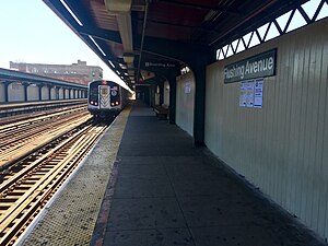
The Flushing Avenue station is a local station on the BMT Jamaica Line of the New York City Subway. Located at the intersection of Flushing Avenue and Broadway in Bedford–Stuyvesant, Brooklyn, it is served by the J train at all times except weekdays in the peak direction and the M train at all times except late nights. The Z train skips this station when it operates.

Flushing Avenue station (IND Crosstown Line)
New York City Subway station in Brooklyn
Distance: Approx. 367 meters
Latitude and longitude: 40.699739,-73.950176
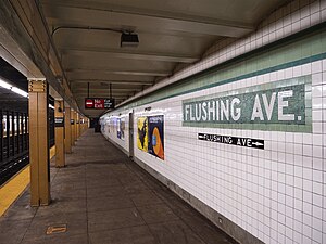
The Flushing Avenue station is a station on the IND Crosstown Line of the New York City Subway. Located at the intersection of Flushing and Union/Marcy Avenues in the boundary of Bedford–Stuyvesant and Williamsburg, Brooklyn, it is served at all times by the G train.

Marcy Houses
Public housing development in Brooklyn, New York
Distance: Approx. 600 meters
Latitude and longitude: 40.697,-73.951
The Marcy Houses, or The Marcy Projects, is a public housing complex built and operated by the New York City Housing Authority (NYCHA) and located in Bedford–Stuyvesant and is bordered by Flushing, Marcy, Nostrand and Myrtle avenues. The complex was named after William L. Marcy (1786–1857), a lawyer, soldier, and statesman. Consisting of 27 six-story buildings on 28.49 acres (0.1153 km2; 0.04452 sq mi), it contains 1,705 apartments housing about 4,286 residents (average of 2.5 people to an apartment).
Woodhull Medical Center
Hospital in New York, United States
Distance: Approx. 344 meters
Latitude and longitude: 40.69944444,-73.9425
Woodhull Medical Center, branded as NYC Health + Hospitals/Woodhull, is a health care system located in the Bedford–Stuyvesant section of Brooklyn, New York City, United States. Its focus is on preventing disease and promoting healthy lifestyles in the community of North Brooklyn through its fifteen centers. Woodhull Medical and Mental Health Center falls administratively under New York City Health and Hospitals Corporation.
Tompkins Avenue station (BMT Myrtle Avenue Line)
New York City Subway station in Brooklyn, New York
Distance: Approx. 578 meters
Latitude and longitude: 40.695711,-73.946367
The Tompkins Avenue station was a station on the demolished section of the BMT Myrtle Avenue Line. The station was located at the intersection of Myrtle and Tompkins Avenues in Bedford-Stuyvesant, Brooklyn. The station opened in 1889, and closed in 1969.
Moore Street Retail Market
Distance: Approx. 552 meters
Latitude and longitude: 40.704,-73.941
Moore Street Market, often referred to as La Marqueta de Williamsburg, is one of four surviving public markets built by mayor Fiorello La Guardia in New York City in 1941 to get pushcarts off crowded and unclean streets. It is located at 110 Moore Street in the Williamsburg neighborhood of northern Brooklyn. In early 2007, Moore Street Market was under the impending threat of closure by its owner and manager, the New York City Economic Development Corporation (NYC EDC).

St. George's Protestant Episcopal Church (Brooklyn)
United States historic place
Distance: Approx. 252 meters
Latitude and longitude: 40.70277778,-73.94777778
St. George's Protestant Episcopal Church, also known as St. George's Episcopal/Anglican Church, is a historic Episcopal church at 800 Marcy Avenue in Bedford-Stuyvesant, Brooklyn, in New York City.
United States Post Office (Williamsburg, Brooklyn)
Historic post office in Brooklyn, New York
Distance: Approx. 426 meters
Latitude and longitude: 40.70194444,-73.94125
US Post Office-Metropolitan Station, originally known as Station "A," is a historic post office building located at Williamsburg in Brooklyn, New York, United States. It was built in 1936, and is one of a number of post offices in New York designed by the Office of the Supervising Architect under Louis A. Simon. The building is a two-story, flat roofed brick building with a three bay wide central pavilion flanked by three bay wide wings in the Colonial Revival style.

IS 318
Public school in New York City, New York
Distance: Approx. 344 meters
Latitude and longitude: 40.70344,-73.94842
Intermediate School 318 (IS 318; also known as the Eugenio Maria de Hostos School) is a public junior high school at 101 Walton Street in Williamsburg, Brooklyn, New York City. Most of the school's 1,623 students, who are sixth-, seventh-, and eighth-graders, are from Williamsburg. The school has 134 teachers.
2014 killings of NYPD officers
Murders of two police officers in New York City
Distance: Approx. 557 meters
Latitude and longitude: 40.6959,-73.946464
On December 20, 2014, Ismaaiyl Abdullah Brinsley shot and killed Rafael Ramos and Wenjian Liu — two on-duty New York City Police Department (NYPD) officers — in the Bedford–Stuyvesant neighborhood of Brooklyn. Brinsley then fled into the New York City Subway, where he killed himself. Earlier in the day, before he killed Ramos and Liu, Brinsley had shot and wounded his ex-girlfriend Shaneka Thompson in Baltimore after initially pointing the gun at his own head.
Lindsay Park (housing cooperative)
Housing cooperative in Brooklyn, New York
Distance: Approx. 463 meters
Latitude and longitude: 40.705,-73.947
Lindsay Park is a housing cooperative located in the East Williamsburg neighborhood of Brooklyn in New York City. The cooperative is part of the Mitchell-Lama Housing Program, through which the state of New York grants it tax exemptions to maintain affordability. With 2702 units, it is the largest Mitchell-Lama co-op in Brooklyn.
Weather in this IP's area
smoke
10 Celsius
8 Celsius
7 Celsius
11 Celsius
1027 hPa
33 %
1027 hPa
1027 hPa
10000 meters
3.09 m/s
340 degree
20 %
06:36:06
16:43:18

