Country:
Region:
City:
Latitude and Longitude:
Time Zone:
Postal Code:
IP information under different IP Channel
ip-api
Country
Region
City
ASN
Time Zone
ISP
Blacklist
Proxy
Latitude
Longitude
Postal
Route
IPinfo
Country
Region
City
ASN
Time Zone
ISP
Blacklist
Proxy
Latitude
Longitude
Postal
Route
MaxMind
Country
Region
City
ASN
Time Zone
ISP
Blacklist
Proxy
Latitude
Longitude
Postal
Route
Luminati
Country
Region
wa
City
perth
ASN
Time Zone
Australia/Perth
ISP
TPG Telecom Limited
Latitude
Longitude
Postal
db-ip
Country
Region
City
ASN
Time Zone
ISP
Blacklist
Proxy
Latitude
Longitude
Postal
Route
ipdata
Country
Region
City
ASN
Time Zone
ISP
Blacklist
Proxy
Latitude
Longitude
Postal
Route
Popular places and events near this IP address
Bull Creek, Western Australia
Suburb of Perth, Western Australia
Distance: Approx. 874 meters
Latitude and longitude: -32.0562543,115.8624527
Bull Creek is a suburb of Perth, Western Australia, located within the local government area of City of Melville. The suburb lies to the south of a creek of the same name, which flows into the Canning River.

Willetton Senior High School
School in Willetton, Western Australia
Distance: Approx. 818 meters
Latitude and longitude: -32.059836,115.87894
Willetton Senior High School (WSHS) is a public secondary school in Willetton, Western Australia, 12 kilometres (7.5 miles) south of the Perth central business district and 12.6 kilometres (7.8 miles) east of the port of Fremantle. The school opened in February 1977 with 77 students. It is one of the largest schools in Western Australia, with 2,712 enrolled students as of 11 May 2024.

Leeming, Western Australia
Suburb of Perth, Western Australia
Distance: Approx. 2263 meters
Latitude and longitude: -32.0757784,115.8672721
Leeming is a southern suburb of Perth, Western Australia. It is divided between the three local government areas of the City of Melville, the City of Cockburn (south) and the City of Canning (north-east). It is located approximately 17 kilometres (11 mi) south of the Perth central business district and 13 kilometres (8.1 mi) east of Fremantle.

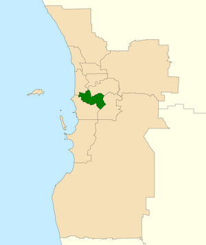
Division of Tangney
Australian federal electoral division
Distance: Approx. 403 meters
Latitude and longitude: -32.053,115.869
The Division of Tangney is an Australian electoral division in the state of Western Australia. The Division was named after Dame Dorothy Tangney, the first female member of the Australian Senate. Tangney is an affluent electorate covering the southern shores of the Swan and Canning rivers, divided by the Kwinana Freeway.

Brentwood, Western Australia
Suburb of Perth, Western Australia
Distance: Approx. 2273 meters
Latitude and longitude: -32.0435208,115.8524477
Brentwood is a suburb of Perth, Western Australia, located within the City of Melville and approximately 10 kilometres (6.2 mi) from the Perth CBD. The nearest airport is Perth Airport (16 kilometres or 9.9 miles away) and the nearest railway station is Bull Creek (0.8 kilometres or 0.50 miles away).
Rossmoyne, Western Australia
Suburb of Perth, Western Australia
Distance: Approx. 1836 meters
Latitude and longitude: -32.039618,115.8679219
Rossmoyne is a suburb of Perth, Western Australia, within the City of Canning. Rossmoyne is located 14 kilometres (8.7 mi) south of central Perth, and is bounded by Leach Highway to the south, the Bull Creek to the west, the Canning River to the north, and Shelley to the east. The area has a beautiful river front and many parks to walk your dogs.

Willetton, Western Australia
Suburb of Perth, Western Australia
Distance: Approx. 1566 meters
Latitude and longitude: -32.0524594,115.8878267
Willetton is a large southern suburb of Perth, Western Australia. Its local government area is the City of Canning.

Bull Creek railway station
Railway station in Perth, Western Australia
Distance: Approx. 1927 meters
Latitude and longitude: -32.046866,115.854211
Bull Creek railway station is a railway station on the Transperth network. It is located on the Mandurah line, 11.7 kilometres from Perth station inside the median strip of the Kwinana Freeway serving the suburb of Bull Creek.
Rossmoyne Senior High School
School in Bull Creek, Western Australia
Distance: Approx. 1114 meters
Latitude and longitude: -32.0459,115.87
Rossmoyne Senior High School is a public co-educational high day school in the City of Melville, located on Keith Road, Bull Creek, a southern riverside suburb of Perth, Western Australia. Founded in 1968, it is one of the largest schools in Western Australia, with 2,694 enrolled students as of 11 May 2024.

Murdoch railway station
Railway station in Perth, Western Australia
Distance: Approx. 2306 meters
Latitude and longitude: -32.066208,115.850571
Murdoch railway station is a railway and bus station on the Transperth network. It is located on the Mandurah line, 13.8 kilometres (8.6 mi) from Perth station inside the median strip of the Kwinana Freeway serving the suburb of Murdoch.
All Saints' College, Perth
School in Australia
Distance: Approx. 684 meters
Latitude and longitude: -32.052,115.866
All Saints' College is an independent Anglican co-educational early learning, primary, and secondary day school, located in Bull Creek, a southern suburb of Perth, Western Australia. The college is situated on 19 hectares (47 acres), approximately ten kilometres (six miles) south of the Perth central business district. The college was founded in 1981 as the first coeducational Anglican secondary school in the Perth metropolitan area and the first Anglican secondary school in the southern suburbs, and now caters for students from pre-kindergarten to Year 12/13.

Aviation Heritage Museum (Western Australia)
Aviation museum in Bull Creek, Western Australia
Distance: Approx. 1400 meters
Latitude and longitude: -32.0493,115.859
The Aviation Heritage Museum is a museum located in the Perth suburb of Bull Creek in Western Australia. Created and maintained by the Air Force Association of Western Australia, it houses many military and civilian aircraft, aircraft replicas and aircraft engines, of types that have served in the Royal Australian Air Force or that have relevance to aviation in Western Australia.
Weather in this IP's area
smoke
17 Celsius
16 Celsius
15 Celsius
18 Celsius
1026 hPa
54 %
1026 hPa
1023 hPa
10000 meters
4.63 m/s
160 degree
4 %
05:43:49
18:23:27

