Country:
 Australia
Region:
City:
Latitude and Longitude:
Time Zone:
Postal Code:
IP information under different IP Channel
ip-api
Country
Region
City
ASN
Time Zone
ISP
Blacklist
Proxy
Latitude
Longitude
Postal
Route
IPinfo
Country
Region
City
ASN
Time Zone
ISP
Blacklist
Proxy
Latitude
Longitude
Postal
Route
MaxMind
Country
Region
City
ASN
Time Zone
ISP
Blacklist
Proxy
Latitude
Longitude
Postal
Route
Luminati
Country
AURegion
wa
City
perth
ASN
Time Zone
Australia/Perth
ISP
TPG Telecom Limited
Latitude
Longitude
Postal
db-ip
Country
Region
City
ASN
Time Zone
ISP
Blacklist
Proxy
Latitude
Longitude
Postal
Route
ipdata
Country
Region
City
ASN
Time Zone
ISP
Blacklist
Proxy
Latitude
Longitude
Postal
Route
Popular places and events near this IP address

City of Bayswater
Local government area in Western Australia
Distance: Approx. 304 meters
Latitude and longitude: -31.887,115.907
The City of Bayswater is a local government area in the Western Australian capital city of Perth, about 7 kilometres (4 mi) northeast of Perth's central business district. The city covers an area of 34.6 square kilometres (13.4 sq mi) and had a population of 69,283 as at the 2021 Census. The City of Bayswater is a member of the Eastern Metropolitan Regional Council.

Morley, Western Australia
Suburb of Perth, Western Australia
Distance: Approx. 304 meters
Latitude and longitude: -31.887,115.907
Morley is a suburb of Perth, within the City of Bayswater local government area, situated approximately 10 kilometres (6 mi) northeast of the Perth central business district. It contains the Galleria Shopping Centre, one of Perth's larger shopping centres. Morley bus station is located in the car park of the shopping centre.

Division of Perth
Australian federal electoral division
Distance: Approx. 2345 meters
Latitude and longitude: -31.91,115.905
The Division of Perth is an Australian electoral division in the state of Western Australia. It is named after Perth, the capital city of Western Australia, where the Division is located.

Morley bus station
Bus station in Perth, Western Australia
Distance: Approx. 1500 meters
Latitude and longitude: -31.899,115.898
Morley bus station is a Transperth bus station located next to the Galleria Shopping Centre in Morley, Western Australia.

Embleton, Western Australia
Suburb of Perth, Western Australia
Distance: Approx. 1651 meters
Latitude and longitude: -31.904,115.91
Embleton is a suburb of Perth, the capital city of Western Australia, located 7 kilometres (4.3 mi) north-east of the central business district, between the suburbs of Morley and Bayswater. Its local government area is the City of Bayswater.
Hazelmere, Western Australia
Suburb of Perth, Western Australia
Distance: Approx. 1805 meters
Latitude and longitude: -31.901,115.922
Hazelmere is a suburb of Perth, 14 kilometres (9 mi) east of the Perth central business district, in the City of Swan. Bordered by Roe Highway to the east, and the Great Eastern Highway Bypass to the south, Hazelmere is at the northern edge of Perth Airport land.

Galleria Shopping Centre (Perth)
Shopping mall in Morley, Western Australia
Distance: Approx. 1269 meters
Latitude and longitude: -31.897169,115.899292
Galleria Shopping Centre (formerly known as Westfield Galleria, Centro Galleria and Galleria) is a shopping centre located in Morley, about 8 kilometres (5 mi) northeast of the Perth central business district. It is the 5th largest shopping centre in Western Australia, with several major retailers and approximately 300 specialty retailers. The present centre was constructed in stages between 1988 with Coles and Kmart Australia, and in 1994 with Event Cinemas and Myer.

Morley railway station, Perth
Proposed railway station in Perth, Western Australia
Distance: Approx. 1294 meters
Latitude and longitude: -31.896,115.92
Morley railway station is a suburban rail and bus interchange station under construction as part of the Metronet Morley–Ellenbrook railway line, serving the Perth suburbs of Bayswater, Embleton and Morley. It is to be built in the median strip of Tonkin Highway at Broun Avenue.

Noranda railway station
Proposed railway station in Australia
Distance: Approx. 1898 meters
Latitude and longitude: -31.874,115.918
Noranda railway station is a suburban rail station under construction as part of the Transperth network. It is planned to open in 2024 as a station on the Morley–Ellenbrook railway line, serving the Perth suburbs of Beechboro, Kiara and Noranda. It is being built in the median of Tonkin Highway, just north of Benara Road.

John Forrest Secondary College
School in Morley, Western Australia
Distance: Approx. 1875 meters
Latitude and longitude: -31.904621,115.900917
John Forrest Secondary College (abbreviated as JFSC) is an Independent Public secondary school in the Perth suburb of Morley, Western Australia.

Hampton Senior High School
School in Australia
Distance: Approx. 1722 meters
Latitude and longitude: -31.891,115.927
Hampton Senior High School is an Independent public co-educational high day school, located in the Perth suburb of Morley, Western Australia.
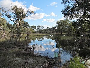
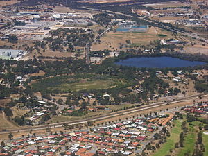
Lightning Swamp Bushland
Bushland in Perth, Western Australia
Distance: Approx. 2258 meters
Latitude and longitude: -31.8691,115.9057
Lightning Swamp Bushland is a 71.3-hectare (176-acre) area of natural bush and wetlands in Noranda, Western Australia, a suburb of Perth. It is bounded by Reid Highway to the north, Malaga Drive to the west and south, Matthews Close to the south and Lightning Park Recreation Centre to the east. It is classified as an A class reserve.
Weather in this IP's area
smoke
17 Celsius
16 Celsius
15 Celsius
18 Celsius
1026 hPa
59 %
1026 hPa
1022 hPa
5000 meters
4.63 m/s
160 degree
10 %
05:43:46
18:23:11