Country:
 Australia
Region:
City:
Latitude and Longitude:
Time Zone:
Postal Code:
IP information under different IP Channel
ip-api
Country
Region
City
ASN
Time Zone
ISP
Blacklist
Proxy
Latitude
Longitude
Postal
Route
IPinfo
Country
Region
City
ASN
Time Zone
ISP
Blacklist
Proxy
Latitude
Longitude
Postal
Route
MaxMind
Country
Region
City
ASN
Time Zone
ISP
Blacklist
Proxy
Latitude
Longitude
Postal
Route
Luminati
Country
AURegion
wa
City
perth
ASN
Time Zone
Australia/Perth
ISP
TPG Telecom Limited
Latitude
Longitude
Postal
db-ip
Country
Region
City
ASN
Time Zone
ISP
Blacklist
Proxy
Latitude
Longitude
Postal
Route
ipdata
Country
Region
City
ASN
Time Zone
ISP
Blacklist
Proxy
Latitude
Longitude
Postal
Route
Popular places and events near this IP address

Hyde Park, Perth
Park in Perth, Western Australia
Distance: Approx. 944 meters
Latitude and longitude: -31.937875,115.862895
Hyde Park (formerly Third Swamp Reserve) is an inner-city park in Perth, the state capital of Western Australia. It is located in the north-east corner of the suburb of Perth – 2 km (1.2 mi) north of the central business district – surrounded by Vincent, William, Glendower and Throssell Streets. Facilities include: public toilets, playground equipment, barbecues, drinking fountains, pavilion, stage area, fitness equipment and a sealed walking path of around 800 m (870 yd) in length ringing the lake.
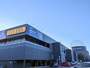
Scitech
Science museum in Perth, Western Australia
Distance: Approx. 922 meters
Latitude and longitude: -31.9443,115.847
Scitech is a not-for-profit company encompassing the Scitech Discovery Centre, an interactive science centre in West Perth, Western Australia, outreach programs, professional learning programs and digital content. The organisation's purpose is to inspire engagement by all Western Australians in science, technology, engineering and mathematics.

Leederville Oval
Football stadium in Perth, Western Australia
Distance: Approx. 893 meters
Latitude and longitude: -31.93527778,115.84388889
Leederville Oval (known as Medibank Stadium under a naming rights agreement between 2006 and 2016) is an Australian rules football ground located in Leederville, a suburb of Perth, Western Australia. The ground is used as a home ground by two clubs: the East Perth Football Club and the Subiaco Football Club, both competing in the West Australian Football League (WAFL). The ground was previously home to the West Perth Football Club from 1915 to 1993, before the club moved to Arena Joondalup, its current home ground.

Dorrien Gardens
Sports ground in West Perth, Western Australia
Distance: Approx. 238 meters
Latitude and longitude: -31.93888889,115.855
Dorrien Gardens is a sports ground in West Perth, Western Australia primarily used for soccer.
6EBA-FM
Radio station in Perth, Western Australia
Distance: Approx. 757 meters
Latitude and longitude: -31.9335,115.8592
6EBA (95.3 FM) is a multicultural broadcast radio station in Perth, Western Australia. It is Perth's only full-time, community owned and operated multilingual radio station, which began broadcasting from its first studio in View Street, North Perth in 1990. Hosting 82 different languages, 6EBA's programming includes contributions from new and emerging communities to the older established ethnic communities such as Greek, Italian, Arabic and Bosnian, Serbian, Croatian languages.

Beatty Park
Swimming pool in Perth, Western Australia
Distance: Approx. 448 meters
Latitude and longitude: -31.93555556,115.84888889
Beatty Park Leisure Centre is a swimming pool complex in the suburb of North Perth, Western Australia. Originally known as the Beatty Park Aquatic Centre, it was built for the 1962 British Empire and Commonwealth Games as the major swimming event venue, along with the Perry Lakes Stadium athletics complex. Prior to the construction of the centre, the area was part of a large reserve known as Beatty Park.
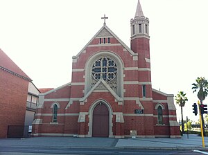
St Brigid's Church, Perth
Church in Australia
Distance: Approx. 719 meters
Latitude and longitude: -31.944148,115.853297
St Brigid's Church is a heritage-listed Roman Catholic church in Northbridge, Western Australia. The church precinct comprises the church building itself, a convent, a presbytery and a school, situated on a block of land bounded by Aberdeen Street (to the north-east), Fitzgerald Street (to the south-east), John Street (to the south-west) and a park and freeway exits (to the north-west).

Trinity Theological College, Perth
Theological college in Leederville, Perth, Australia
Distance: Approx. 833 meters
Latitude and longitude: -31.93846,115.84413
Trinity Theological College, located in Leederville, Perth, Western Australia, is an independent theological college which provides tertiary education within the evangelical and reformed Christian traditions. Its courses are accredited through the Australian College of Theology (ACT), and range from undergraduate diplomas through to postgraduate research degrees. As a non-denominational theological college, Trinity provides education to both men and women across a range of denominations, including Anglican, Baptist, and Presbyterian.

Redemptorist Monastery, North Perth
Church in Perth, Western Australia
Distance: Approx. 275 meters
Latitude and longitude: -31.935769,115.854709
The Redemptorist Monastery Church in North Perth, Western Australia, is a Roman Catholic church and adjacent monastery built in 1903 for the Redemptorist Order.

Northbridge, Western Australia
Suburb of Perth, Western Australia
Distance: Approx. 930 meters
Latitude and longitude: -31.946,115.854
Northbridge is an inner city suburb of Perth, Western Australia, historically separated from Perth's central business district by the Fremantle and Joondalup railway lines. It is part of the City of Perth local government area.
Rosemount Hotel
Music venue in North Perth, Western Australia
Distance: Approx. 952 meters
Latitude and longitude: -31.930889,115.85899
Rosemount Hotel, also known colloquially as Rosemount and Rosie, is a live music venue in North Perth, Western Australia. Originally built in 1902, during Western Australia's gold boom, the hotel has been continuously licensed for over a century.

Nine Japanese Bistro
Restaurant in Perth, Western Australia
Distance: Approx. 889 meters
Latitude and longitude: -31.94034095,115.86177728
Nine Japanese Bistro (formerly Nine Fine Food) is a Japanese-fusion restaurant in the suburb of Perth, Western Australia. Situated in Perth's inner city on the corner of Lake and Bulwer streets, the restaurant was opened in 2003 by its chef, Muneki Song.
Weather in this IP's area
smoke
17 Celsius
16 Celsius
15 Celsius
18 Celsius
1026 hPa
57 %
1026 hPa
1023 hPa
5000 meters
4.63 m/s
160 degree
7 %
05:43:58
18:23:27