Country:
 Australia
Region:
City:
Latitude and Longitude:
Time Zone:
Postal Code:
IP information under different IP Channel
ip-api
Country
Region
City
ASN
Time Zone
ISP
Blacklist
Proxy
Latitude
Longitude
Postal
Route
IPinfo
Country
Region
City
ASN
Time Zone
ISP
Blacklist
Proxy
Latitude
Longitude
Postal
Route
MaxMind
Country
Region
City
ASN
Time Zone
ISP
Blacklist
Proxy
Latitude
Longitude
Postal
Route
Luminati
Country
AURegion
wa
City
perth
ASN
Time Zone
Australia/Perth
ISP
TPG Telecom Limited
Latitude
Longitude
Postal
db-ip
Country
Region
City
ASN
Time Zone
ISP
Blacklist
Proxy
Latitude
Longitude
Postal
Route
ipdata
Country
Region
City
ASN
Time Zone
ISP
Blacklist
Proxy
Latitude
Longitude
Postal
Route
Popular places and events near this IP address
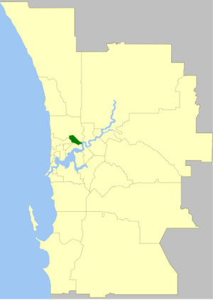
City of Vincent
Local government area in Western Australia
Distance: Approx. 805 meters
Latitude and longitude: -31.936,115.834
The City of Vincent is a local government area of Western Australia. It covers an area of approximately 10.4 square kilometres (4.0 sq mi) in metropolitan Perth, the capital of Western Australia, and lies about 3 km from the Perth CBD. The City of Vincent maintains 139 km of roads and 104 ha of parks and gardens. It had a population of over 33,000 at the 2016 Census.

Leederville, Western Australia
Suburb of Perth, Western Australia
Distance: Approx. 805 meters
Latitude and longitude: -31.936,115.834
Leederville is a suburb within the City of Vincent in the Perth metropolitan region of Western Australia. It is home to Aranmore Catholic College, the School of Isolated and Distance Education, North Metropolitan TAFE, Trinity Theological College, and St Mary's Church. The suburb was named after William Henry Leeder, the original grantee of land that encompassed the area.

West Leederville, Western Australia
Suburb of Perth, Western Australia
Distance: Approx. 1097 meters
Latitude and longitude: -31.938,115.832
West Leederville is a suburb 3 kilometres (1.9 mi) northwest of the central business district of Perth, the capital of Western Australia, and is within the Town of Cambridge. It used to be integrated with Leederville prior to the construction of the Mitchell Freeway through the suburb in 1972. The tiny section east of Southport Street is a commercial area with several warehouses, taking advantage of its location at the end of the Graham Farmer Freeway.
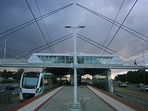
Leederville railway station
Railway station in Perth, Western Australia
Distance: Approx. 915 meters
Latitude and longitude: -31.938907,115.840273
Leederville railway station is a suburban railway station on the boundary of Leederville and West Leederville, suburbs of Perth, Western Australia. The station is on the Yanchep line and is part of the Transperth network. Located within the median strip of the Mitchell Freeway, Leederville station consists of an island platform connected to either side of the freeway by a footbridge.

Mount Hawthorn, Western Australia
Suburb of Perth, Western Australia
Distance: Approx. 1093 meters
Latitude and longitude: -31.921,115.838
Mount Hawthorn is a suburb of Perth, Western Australia, located within the City of Vincent. The Mount Hawthorn area was first selected for urban development in 1887. In the late 1890s part of it was purchased by a syndicate of Edward Wittenoom, a politician and pastoralist; James Hicks and C. L. W. Clifton.

Aranmore Catholic College
School in Western Australia
Distance: Approx. 450 meters
Latitude and longitude: -31.9277,115.843
The Aranmore Catholic College is a co-educational school for ages 7–12, located in Leederville in Perth, Western Australia. It was founded in 1903 by Sisters of Mercy, Mother Berchmans and Mother Aquin.

Leederville Oval
Football stadium in Perth, Western Australia
Distance: Approx. 639 meters
Latitude and longitude: -31.93527778,115.84388889
Leederville Oval (known as Medibank Stadium under a naming rights agreement between 2006 and 2016) is an Australian rules football ground located in Leederville, a suburb of Perth, Western Australia. The ground is used as a home ground by two clubs: the East Perth Football Club and the Subiaco Football Club, both competing in the West Australian Football League (WAFL). The ground was previously home to the West Perth Football Club from 1915 to 1993, before the club moved to Arena Joondalup, its current home ground.

Beatty Park
Swimming pool in Perth, Western Australia
Distance: Approx. 1015 meters
Latitude and longitude: -31.93555556,115.84888889
Beatty Park Leisure Centre is a swimming pool complex in the suburb of North Perth, Western Australia. Originally known as the Beatty Park Aquatic Centre, it was built for the 1962 British Empire and Commonwealth Games as the major swimming event venue, along with the Perry Lakes Stadium athletics complex. Prior to the construction of the centre, the area was part of a large reserve known as Beatty Park.

Luna Leederville
Cinema in Perth, Western Australia
Distance: Approx. 623 meters
Latitude and longitude: -31.9362,115.841
Luna Leederville (formerly New Oxford Theatre, Nickelodeon, Olympia, Star Theatre and Luna Cinema) is a cinema complex located at the corner of Oxford and Vincent Streets in Leederville, a suburb of Perth, Western Australia.

Perth Wetlands
Bodies of water on Swan Coastal Plain
Distance: Approx. 1154 meters
Latitude and longitude: -31.92888889,115.82777778
The Perth Wetlands, also known as the Perth Great Lakes or the Great Lakes District, was a collection of fresh-water wetlands, swamps and lakes located on the Swan Coastal Plain north of the city of Perth in Western Australia. Over a period of 80 years from the first British settlement in Western Australia in 1829 most of the wetlands were reclaimed for use as housing, parks and market gardens.

Trinity Theological College, Perth
Theological college in Leederville, Perth, Australia
Distance: Approx. 956 meters
Latitude and longitude: -31.93846,115.84413
Trinity Theological College, located in Leederville, Perth, Western Australia, is an independent theological college which provides tertiary education within the evangelical and reformed Christian traditions. Its courses are accredited through the Australian College of Theology (ACT), and range from undergraduate diplomas through to postgraduate research degrees. As a non-denominational theological college, Trinity provides education to both men and women across a range of denominations, including Anglican, Baptist, and Presbyterian.
Anzac Cottage
Building in Mount Hawthorn, Western Australia
Distance: Approx. 935 meters
Latitude and longitude: -31.9235,115.8347
Anzac Cottage is a house in the suburb of Mount Hawthorn, Western Australia that was built as both a memorial to the soldiers who died in the Gallipoli Campaign and as a home for one of the wounded returning men. It is notable for being the first World War I memorial built in Western Australia, and for (nominally) being built in a single day (12 February 1916) with donated funds, materials and labour.
Weather in this IP's area
smoke
17 Celsius
16 Celsius
15 Celsius
18 Celsius
1026 hPa
59 %
1026 hPa
1023 hPa
5000 meters
4.63 m/s
160 degree
7 %
05:44:01
18:23:30