Country:
Region:
City:
Latitude and Longitude:
Time Zone:
Postal Code:
IP information under different IP Channel
ip-api
Country
Region
City
ASN
Time Zone
ISP
Blacklist
Proxy
Latitude
Longitude
Postal
Route
IPinfo
Country
Region
City
ASN
Time Zone
ISP
Blacklist
Proxy
Latitude
Longitude
Postal
Route
MaxMind
Country
Region
City
ASN
Time Zone
ISP
Blacklist
Proxy
Latitude
Longitude
Postal
Route
Luminati
Country
Region
wa
City
perth
ASN
Time Zone
Australia/Perth
ISP
TPG Telecom Limited
Latitude
Longitude
Postal
db-ip
Country
Region
City
ASN
Time Zone
ISP
Blacklist
Proxy
Latitude
Longitude
Postal
Route
ipdata
Country
Region
City
ASN
Time Zone
ISP
Blacklist
Proxy
Latitude
Longitude
Postal
Route
Popular places and events near this IP address

Mundy Regional Park
Regional park in Western Australia
Distance: Approx. 2844 meters
Latitude and longitude: -31.99638889,116.03027778
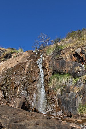
The Mundy Regional Park is a regional park located on the western edge of the Darling Scarp, approximately 22 kilometres (14 mi) east of Perth in Western Australia. The 56-hectare (140-acre) park has commanding views of the Swan Coastal Plain, the city of Perth and surrounding suburbs. The park is managed by the Department of Biodiversity, Conservation and Attractions.

Forrestfield, Western Australia
Suburb of Perth, Western Australia
Distance: Approx. 1077 meters
Latitude and longitude: -31.98,115.993611
Forrestfield is a suburb of the City of Kalamunda in Western Australia. It lies 15 kilometres to the south-east of Perth at the base of the Darling Scarp and the southern border of Perth Airport. The suburb is split by Roe Highway into a southern residential area and a northern industrial area.

Division of Hasluck
Australian federal electoral division
Distance: Approx. 1534 meters
Latitude and longitude: -31.997,116.008
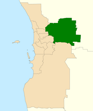
The Division of Hasluck is an electoral division of the Australian House of Representatives, located in Western Australia.

Kewdale Freight Terminal
Port
Distance: Approx. 3606 meters
Latitude and longitude: -31.983994,115.966016
Kewdale Freight Terminal is a large intermodal rail facility in the Perth suburb of Kewdale, Western Australia. Branching off the Kwinana freight railway, it was built in the 1960s to replace the Perth marshalling yard. It initially comprised ten narrow gauge (1067mm) and seven standard gauge (1435mm) arrival roads.
High Wycombe, Western Australia
Suburb of Perth, Western Australia
Distance: Approx. 4038 meters
Latitude and longitude: -31.9475,116
High Wycombe () is a suburb of Perth, Western Australia, within the City of Kalamunda. High Wycombe lies east of the Perth CBD at the base of the Darling Scarp (commonly referred to as the foothills). Formerly part of Maida Vale, the suburb was officially declared on 2 June 1978; its name, which was first used in 1958 by a subdivider, Western Agencies, refers to the town in Buckinghamshire where one of the partners in the firm was born.
Maida Vale, Western Australia
Suburb of Perth, Western Australia
Distance: Approx. 3841 meters
Latitude and longitude: -31.953,116.023
Maida Vale is a suburb of Perth, Western Australia, located within the City of Kalamunda. Kalamunda Road runs through the suburb. Its first European settler was William Henry Mead, who arrived in 1873, built a home in the Ridge Hill area and established the orchard Orangedale.

Wattle Grove, Western Australia
Suburb of Perth, Western Australia
Distance: Approx. 2869 meters
Latitude and longitude: -32.008,116.014
Wattle Grove is a suburb of Perth, Western Australia, located within the City of Kalamunda.
Heritage College, Perth
School in Forrestfield, Perth, Western Australia, Australia
Distance: Approx. 1466 meters
Latitude and longitude: -31.982162,116.019637
Heritage College Perth is an independent Christadelphian co-educational primary and secondary day school, located in Forrestfield, a suburb situated in the foothills of Perth, Western Australia. Established in 2006, Heritage College Perth is one of five Christadelphian Heritage Colleges in Australia; the other four are located in Morisset, Adelaide, Sydney, and Melbourne.

Electoral district of Forrestfield
State electoral district in Perth, Western Australia
Distance: Approx. 2265 meters
Latitude and longitude: -32,115.99
Forrestfield is an electoral district of the Legislative Assembly in the Australian state of Western Australia, based in the eastern suburbs of Perth.
Kalamunda Community Radio
Community radio station in Kalamunda, Western Australia
Distance: Approx. 4024 meters
Latitude and longitude: -31.957418,116.033575
Kalamunda Community Radio 102.5FM is a not for profit Community Radio Station based in Perth, Western Australia. KCR 102.5FM includes jazz, blues, country/western, hip hop, classical, gospel, folk, techno, popular easy listening, indigenous, contemporary and classic rock broadcasting 24 hours a day, seven days a week.

High Wycombe railway station, Perth
Railway station in Perth, Western Australia
Distance: Approx. 3418 meters
Latitude and longitude: -31.954628,115.992199
High Wycombe railway station is a Transperth commuter rail station in Perth, Western Australia. The station is the eastern terminus of the Airport line and was one of three stations built as part of the Forrestfield–Airport Link project. The station was originally known as Forrestfield station during planning and construction.
Darling Range Sports College
School in Australia
Distance: Approx. 1084 meters
Latitude and longitude: -31.9754,116.0104
Darling Range Sports College is an Independent Public secondary school in Forrestfield, a suburb 14 kilometres (8.7 mi) east of Perth, Western Australia. Formerly known as Forrestfield Senior High School, the school was renamed in 2008 due to it becoming a specialist sports school.
Weather in this IP's area
smoke
17 Celsius
16 Celsius
15 Celsius
18 Celsius
1026 hPa
56 %
1026 hPa
1021 hPa
5000 meters
4.63 m/s
160 degree
6 %
05:43:20
18:22:52