Country:
 Australia
Region:
City:
Latitude and Longitude:
Time Zone:
Postal Code:
IP information under different IP Channel
ip-api
Country
Region
City
ASN
Time Zone
ISP
Blacklist
Proxy
Latitude
Longitude
Postal
Route
IPinfo
Country
Region
City
ASN
Time Zone
ISP
Blacklist
Proxy
Latitude
Longitude
Postal
Route
MaxMind
Country
Region
City
ASN
Time Zone
ISP
Blacklist
Proxy
Latitude
Longitude
Postal
Route
Luminati
Country
AURegion
wa
City
perth
ASN
Time Zone
Australia/Perth
ISP
TPG Telecom Limited
Latitude
Longitude
Postal
db-ip
Country
Region
City
ASN
Time Zone
ISP
Blacklist
Proxy
Latitude
Longitude
Postal
Route
ipdata
Country
Region
City
ASN
Time Zone
ISP
Blacklist
Proxy
Latitude
Longitude
Postal
Route
Popular places and events near this IP address

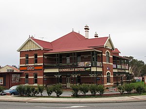
City of Gosnells
Local government area in Perth, Western Australia
Distance: Approx. 2563 meters
Latitude and longitude: -32.072,115.995
The City of Gosnells is a local government area in the southeastern suburbs of the Western Australian capital city of Perth, located northwest of Armadale and about 20 kilometres (12 mi) southeast of Perth's central business district. The City covers an area of 128 square kilometres (49.42 sq mi), a portion of which is state forest rising into the Darling Scarp to the east, and had a population of approximately 118,000 at the 2016 Census. The largest activity centre in the City is the Central Maddington shopping centre.

Seaforth railway station
Railway station in Perth, Western Australia
Distance: Approx. 1433 meters
Latitude and longitude: -32.084852,116.011001
Seaforth railway station is a suburban railway station in Gosnells, a suburb of Perth, Western Australia. It is on the Armadale line which is part of the Transperth network, and is 22.6 kilometres (14.0 mi) southwest of Perth station and 7.8 kilometres (4.8 mi) north of Armadale station. The station opened on 4 May 1948 with low level platforms.

Gosnells railway station
Railway station in Perth, Western Australia
Distance: Approx. 1788 meters
Latitude and longitude: -32.073675,116.003013
Gosnells railway station is located on the South Western Railway 21 kilometres from Perth Station in the suburb of Gosnells. It is served by Armadale Line services which are part of the Transperth network.
Maddington, Western Australia
Suburb of Perth, Western Australia
Distance: Approx. 4231 meters
Latitude and longitude: -32.049,115.99
Maddington is a suburb 20 kilometres (12 mi) southeast of the central business district of Perth, the capital of Western Australia, within the City of Gosnells local government area. Maddington is a mixed-use suburb containing major residential, retail and industrial sections as well as some semi-rural areas. Unusual amongst the surrounding suburbs Maddington still retains several vineyards and orchards from when the locality was used for agricultural purposes.
Martin, Western Australia
Suburb of Perth, Western Australia
Distance: Approx. 1530 meters
Latitude and longitude: -32.071,116.037
Martin is a suburb of Perth, Western Australia, located within the City of Gosnells. It was named in 1974 after a pioneer family of the Gosnells district, and in particular Edward Victor Martin who had served for 37 years on the council. Martin was formerly the location of the popular tourist attraction Cohuna Koala Park owned and run by the Sorbello family at 322 Mills Road East.
Gosnells, Western Australia
Suburb of Perth, Western Australia
Distance: Approx. 2563 meters
Latitude and longitude: -32.072,115.995
Gosnells is a suburb located within the City of Gosnells. Gosnells is approximately 20 kilometres (12 mi) south-east of the Perth central business district. It contains the Gosnells town centre which includes the Council offices, library and the Gosnells Railway Station.
Heritage FM
Radio station in Gosnells
Distance: Approx. 2181 meters
Latitude and longitude: -32.0669,116.0012
107.3 HFM (call sign: 6HFM) is a community radio station that broadcasts on 107.3 MHz FM from its studios at 44 Mills Road West in Gosnells, Western Australia. It broadcasts a wide range of locally produced music and information programs. The station commenced broadcasting on 26 January 1998 from studios in Orchard Avenue, Armadale, Western Australia on the 93.7 MHz FM frequency and continued on that frequency until it switched to its current 107.3 MHz FM frequency in 2002.
John Wollaston Anglican Community School
School in Camillo, Perth, Western Australia, Australia
Distance: Approx. 3415 meters
Latitude and longitude: -32.1038,116.007
John Wollaston Anglican Community School is an independent Anglican co-educational primary and secondary day school, located in Camillo, Perth, Western Australia. The school was founded in 1989 and offers K-12 education. The school contains over 1,000 students with four different house groups, Hale (blue), Charter (green), Scott (yellow), Ramsden (red).
Yule Brook College
School in Perth, Western Australia
Distance: Approx. 3294 meters
Latitude and longitude: -32.048445,116.008485
Yule Brook College is a public co-educational middle day school, located on Dellar Road in Maddington, a suburb of Perth, Western Australia.
Southern River College
School in Australia
Distance: Approx. 3959 meters
Latitude and longitude: -32.085038,115.981272
Southern River College is an independent public co-educational high day school in the City of Gosnells, located on Southern River Road in Gosnells, a suburb of Perth, Western Australia. The school was established in 1976 as Gosnells Senior High School (renamed in 2003) and has an attendance of approximately 900 students from Year 7 to Year 12. It became an Independent Public School in 2015.
Lumen Christi College, Perth
School in Perth, Western Australia
Distance: Approx. 953 meters
Latitude and longitude: -32.07025,116.01411111
Lumen Christi College is an independent Roman Catholic coeducational secondary day school, located the Perth south-eastern suburb of Martin, Western Australia. The school provides a religious and general education to students from Year 7 to Year 12. The school has five houses, Campbell, Mackillop, Salvado, Tangney & Yagan.

Banyowla Regional Park
Regional park in Perth, Western Australia
Distance: Approx. 3004 meters
Latitude and longitude: -32.05416667,116.04083333
Banyowla Regional Park, formerly Kelmscott-Martin Regional Park, is a conservation park in the Perth Hills, 20 kilometres south-east of Perth, Western Australia, located within the Cities of Gosnells and Armadale. The regional park was re-named in 2008 after Banyowla, who was a Noongar elder at the time of European settlement. Banyowla is one of eleven regional parks in the Perth region of Western Australia.
Weather in this IP's area
smoke
16 Celsius
16 Celsius
15 Celsius
18 Celsius
1026 hPa
56 %
1026 hPa
1021 hPa
10000 meters
4.63 m/s
160 degree
4 %
05:43:12
18:22:52