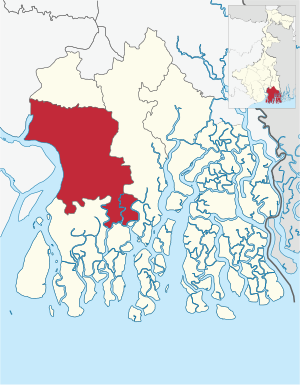
Country:
Region:
City:
Latitude and Longitude:
Time Zone:
Postal Code:
IP information under different IP Channel
ip-api
Country
Region
City
ASN
Time Zone
ISP
Blacklist
Proxy
Latitude
Longitude
Postal
Route
Luminati
Country
Region
wb
City
diamondharbour
ASN
Time Zone
Asia/Kolkata
ISP
Bharti Airtel Ltd., Telemedia Services
Latitude
Longitude
Postal
IPinfo
Country
Region
City
ASN
Time Zone
ISP
Blacklist
Proxy
Latitude
Longitude
Postal
Route
db-ip
Country
Region
City
ASN
Time Zone
ISP
Blacklist
Proxy
Latitude
Longitude
Postal
Route
ipdata
Country
Region
City
ASN
Time Zone
ISP
Blacklist
Proxy
Latitude
Longitude
Postal
Route
Popular places and events near this IP address

Diamond Harbour
Town in West Bengal, India
Distance: Approx. 3726 meters
Latitude and longitude: 22.1910091,88.1904741
Diamond Harbour (Bengali: [ˈɖai̯mənɖ ˈɦaɾbaɾ] ) is a town and a municipality of the South 24 Parganas district in the Indian state of West Bengal. It is situated on the eastern banks of the Hooghly River. It is the headquarters of the Diamond Harbour subdivision.

Diamond Harbour Lok Sabha constituency
Lok Sabha constituency in West Bengal
Distance: Approx. 3726 meters
Latitude and longitude: 22.1910091,88.1904741
Diamond Harbour Lok Sabha constituency is one of the 543 Parliamentary constituencies in India. The constituency centres on Diamond Harbour in West Bengal. All the seven legislative assembly segments of No.

Diamond Harbour subdivision
Subdivision in West Bengal, India
Distance: Approx. 3726 meters
Latitude and longitude: 22.1910091,88.1904741
Diamond Harbour subdivision is an administrative subdivision of the South 24 Parganas district in the Indian state of West Bengal.

Fakir Chand College
College in West Bengal
Distance: Approx. 2442 meters
Latitude and longitude: 22.1965897,88.1787858
Fakir Chand College in Diamond Harbour, West Bengal, India, is a liberal arts, science and commerce college, situated 45 kilometres (28 mi) from Kolkata. It is affiliated to the University of Calcutta. It employs almost 100 teaching staff (50 full-time and 50 part-time, guest or visiting faculty), 50 support staff and 5,500 students.

Diamond Harbour I
Community Development Block in West Bengal, India
Distance: Approx. 3726 meters
Latitude and longitude: 22.1910091,88.1904741
Diamond Harbour I is a community development block that forms an administrative division in the Diamond Harbour subdivision of the South 24 Parganas district in the Indian state of West Bengal.
Diamond Harbour II
Community Development Block in West Bengal, India
Distance: Approx. 3726 meters
Latitude and longitude: 22.1910091,88.1904741
Diamond Harbour II is a community development block (CD block) that forms an administrative division in the Diamond Harbour subdivision of the South 24 Parganas district in the Indian state of West Bengal.
Diamond Harbour Government Polytechnic
Distance: Approx. 2311 meters
Latitude and longitude: 22.19535,88.17459444
Diamond Harbour Government Polytechnic is a government polytechnic established in 2014 and located in Diamond Harbour, South 24 Parganas district, West Bengal. It is affiliated to the West Bengal State Council of Technical Education and recognized by AICTE, New Delhi. It offers diploma courses in Food Processing Technology, Civil Engineering and Mechanical Engineering.

Diamond Harbour railway station
Railway station in West Bengal, India
Distance: Approx. 3656 meters
Latitude and longitude: 22.192571,88.191042
Diamond Harbour railway station is a Kolkata Suburban Railway Station on the Diamond Harbour Branch line. It is under the jurisdiction of the Sealdah railway division in the Eastern Railway zone of the Indian Railways. It serves the local area of Diamond Harbour in South 24 Parganas district in the Indian state of West Bengal.
Diamond Harbour Government Medical College and Hospital
Government Medical College in West Bengal, India
Distance: Approx. 3350 meters
Latitude and longitude: 22.2001,88.1928
Diamond Harbour Government Medical College and Hospital is a full-fledged tertiary referral Government Medical college. The journey of this Medical College and Hospital had started in December, 1974 under the name of Diamond Harbour Sub-divisional Hospital. Later it had been converted to Diamond Harbour District Hospital in April 2012 with 300 beds, and subsequently it was renamed as Diamond Harbour Government Medical College.
Parulia, Diamond Harbour
Village in West Bengal, India
Distance: Approx. 2823 meters
Latitude and longitude: 22.2061,88.1375
Parulia is a village and a gram panchayat within the jurisdiction of the Diamond Harbour police station in the Diamond Harbour I CD block in the Diamond Harbour subdivision of the South 24 Parganas district in the Indian state of West Bengal.
Mohanpur, Diamond Harbour
Census Town in West Bengal, India
Distance: Approx. 2325 meters
Latitude and longitude: 22.2285,88.1794
Mohanpur is a census town within the jurisdiction of the Diamond Harbour police station in the Diamond Harbour I CD block in the Diamond Harbour subdivision of the South 24 Parganas district in the Indian state of West Bengal.

Deulpota
Archaeological site in West Bengal, India
Distance: Approx. 1527 meters
Latitude and longitude: 22.20066667,88.15847222
Deulpota is an archaeological site located beside the Hooghly river, in the Diamond Harbour II CD block in the Diamond Harbour subdivision of the South 24 Parganas district in the Indian state of West Bengal.
Weather in this IP's area
scattered clouds
27 Celsius
29 Celsius
27 Celsius
27 Celsius
1011 hPa
61 %
1011 hPa
1011 hPa
10000 meters
1.29 m/s
2.15 m/s
77 degree
32 %
05:45:22
16:56:53