Country:
Region:
City:
Latitude and Longitude:
Time Zone:
Postal Code:
IP information under different IP Channel
ip-api
Country
Region
City
ASN
Time Zone
ISP
Blacklist
Proxy
Latitude
Longitude
Postal
Route
Luminati
Country
Region
13
City
minamishinagawa
ASN
Time Zone
Asia/Tokyo
ISP
KDDI CORPORATION
Latitude
Longitude
Postal
IPinfo
Country
Region
City
ASN
Time Zone
ISP
Blacklist
Proxy
Latitude
Longitude
Postal
Route
db-ip
Country
Region
City
ASN
Time Zone
ISP
Blacklist
Proxy
Latitude
Longitude
Postal
Route
ipdata
Country
Region
City
ASN
Time Zone
ISP
Blacklist
Proxy
Latitude
Longitude
Postal
Route
Popular places and events near this IP address
Kawasaki-ku, Kawasaki
Ward in Kantō, Japan
Distance: Approx. 1582 meters
Latitude and longitude: 35.52944444,139.70333333
Kawasaki-ku (川崎区) is one of the seven wards of the city of Kawasaki in Kanagawa Prefecture, Japan. As of 2010, the ward had an estimated population of 216,826 and a density of 5,530 persons per km2. The total area was 39.21 square kilometres (15.14 sq mi).

Kanamara Matsuri
Festival in Kawasaki, Japan
Distance: Approx. 1693 meters
Latitude and longitude: 35.53444444,139.72472222
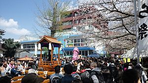
The Shinto Kanamara Matsuri (かなまら祭り, "Festival of the Steel Phallus") is an annual Japanese festival held each spring at the Kanayama Shrine (金山神社, Kanayama-jinja) in Kawasaki, Japan. The exact dates vary: the main festivities fall on the first Sunday in April. The phallus, as the central theme of the event, is reflected in illustrations, candy, carved vegetables, decorations, and a mikoshi parade.

Kawasaki, Kanagawa
Designated city in Kantō, Japan
Distance: Approx. 1601 meters
Latitude and longitude: 35.51666667,139.7
Kawasaki (川崎市, Kawasaki-shi), [kawasaki] is a city in Kanagawa Prefecture, Japan, one of the main cities of the Greater Tokyo Area and Keihin Industrial Area. It is the second most populated city in Kanagawa Prefecture after Yokohama, and the eighth most populated city in Japan (including the Tokyo Metropolitan Area). As of October 1, 2017, the city has an estimated population of 1,503,690, with 716,470 households, and a population density of 10,000 persons per km2.

Shōwa Station (Kanagawa)
Railway station in Kawasaki, Kanagawa Prefecture, Japan
Distance: Approx. 1655 meters
Latitude and longitude: 35.50683611,139.72389722
Shōwa Station (昭和駅, Shōwa-eki) is a passenger railway station located in Kawasaki-ku, Kawasaki, Kanagawa Prefecture, Japan, operated by East Japan Railway Company (JR East).
Kawasaki Stadium
Stadium in Kanagawa, Japan
Distance: Approx. 978 meters
Latitude and longitude: 35.52708333,139.70972222
Kawasaki Stadium (川崎球場, Kawasaki Kyūjō) is a stadium in Kawasaki, Kanagawa, Japan. The stadium was opened in 1952 and had a capacity of 30,000 people, but was demolished and rebuilt in 2003 as an American football venue and is now the home of the Fujitsu Frontiers of the X-League. In its first incarnation, it was primarily used for baseball and was home of the Taiyo Whales until they moved to Yokohama in 1977 and became the Yokohama Taiyo Whales.

Kawasaki Racecourse
Japanese racecourse
Distance: Approx. 1130 meters
Latitude and longitude: 35.53035556,139.71356667
Kawasaki Racecourse (川崎競馬場, Kawasaki Keiba-jō) is located in Kawasaki, Kanagawa, Japan.

Hama-Kawasaki Station
Railway station in Kawasaki, Kanagawa Prefecture, Japan
Distance: Approx. 1222 meters
Latitude and longitude: 35.51,139.7135
Hama-Kawasaki Station (浜川崎駅, Hama-Kawasaki-eki) is a junction passenger railway station in Kawasaki-ku, Kawasaki, Kanagawa Prefecture, Japan, operated by the East Japan Railway Company (JR East) with a freight depot operated by the Japan Freight Railway Company (JR Freight)
Kawasakishimmachi Station
Railway station in Kawasaki, Kanagawa Prefecture, Japan
Distance: Approx. 1627 meters
Latitude and longitude: 35.51818333,139.69929167
Kawasakishimmachi Station (川崎新町駅, Kawasaki-Shinmachi-eki) is a passenger railway station located in Kawasaki-ku, Kawasaki, Kanagawa Prefecture, Japan, operated by East Japan Railway Company (JR East).

Kawasaki Velodrome
Distance: Approx. 1026 meters
Latitude and longitude: 35.52833333,139.71083333
Kawasaki Velodrome (川崎競輪場, Kawasaki Keirinjyō) is a velodrome located in Kawasaki, Kanagawa that conducts pari-mutuel Keirin racing - one of Japan's four authorized "Public Sports" (公営競技, kōei kyōgi) where gambling is permitted. Its Keirin identification number for betting purposes is 34# (34 sharp). Kawasaki's oval is 400 meters in circumference.

Minatochō Station
Railway station in Kawasaki, Kanagawa Prefecture, Japan
Distance: Approx. 1632 meters
Latitude and longitude: 35.5348,139.7125
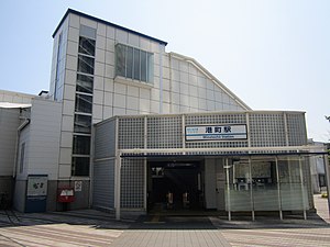
Minatochō Station (港町駅, Minatochō-eki) is a passenger railway station located in Kawasaki-ku, Kawasaki, Kanagawa Prefecture, Japan, operated by the private railway company Keikyū.

Suzukichō Station
Railway station in Kawasaki, Kanagawa Prefecture, Japan
Distance: Approx. 1670 meters
Latitude and longitude: 35.5353,139.7207
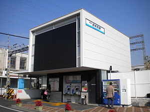
Suzukichō Station (鈴木町駅, Suzukichō-eki) is a passenger railway station located in Kawasaki-ku, Kawasaki, Kanagawa Prefecture, Japan, operated by the private railway operator Keikyū.

Odasakae Station
Railway station in Kawasaki, Kanagawa Prefecture, Japan
Distance: Approx. 1286 meters
Latitude and longitude: 35.5145,139.70494444
Odasakae Station (小田栄駅, Odasakae-eki) is a passenger railway station located in Kawasaki-ku, Kawasaki, Kanagawa Prefecture, Japan, operated by East Japan Railway Company (JR East).
Weather in this IP's area
few clouds
18 Celsius
17 Celsius
14 Celsius
18 Celsius
1023 hPa
72 %
1023 hPa
1022 hPa
10000 meters
2.24 m/s
50 degree
20 %
06:04:41
16:44:37


