106.101.194.70 - IP Lookup: Free IP Address Lookup, Postal Code Lookup, IP Location Lookup, IP ASN, Public IP
Country:
Region:
City:
Location:
Time Zone:
Postal Code:
ISP:
ASN:
language:
User-Agent:
Proxy IP:
Blacklist:
IP information under different IP Channel
ip-api
Country
Region
City
ASN
Time Zone
ISP
Blacklist
Proxy
Latitude
Longitude
Postal
Route
db-ip
Country
Region
City
ASN
Time Zone
ISP
Blacklist
Proxy
Latitude
Longitude
Postal
Route
IPinfo
Country
Region
City
ASN
Time Zone
ISP
Blacklist
Proxy
Latitude
Longitude
Postal
Route
IP2Location
106.101.194.70Country
Region
jeollabuk-do
City
gunsan
Time Zone
Asia/Seoul
ISP
Language
User-Agent
Latitude
Longitude
Postal
ipdata
Country
Region
City
ASN
Time Zone
ISP
Blacklist
Proxy
Latitude
Longitude
Postal
Route
Popular places and events near this IP address

Gunsan
City in North Jeolla, South Korea
Distance: Approx. 5 meters
Latitude and longitude: 35.98333333,126.71666667
Gunsan (Korean: 군산; Korean pronunciation: [kun.sʰan]), also romanized as Kunsan, is a city in Jeonbuk State, South Korea. It is on the south bank of the Geum River just upstream from its exit into the Yellow Sea. It has emerged as a high-tech manufacturing industrial city and an international trade seaport that is approximately 200 km (120 mi) southwest of Seoul on the midwest coast of the Korean Peninsula.

Geum River
Third longest river in South Korea
Distance: Approx. 4875 meters
Latitude and longitude: 36,126.66666667
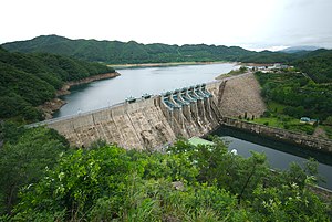
The Geum River is a major river of South Korea that originates in Jangsu-eup, North Jeolla Province. It flows northward through North Jeolla and North Chungcheong Provinces and then changes direction in the vicinity of Greater Daejeon and flows southwest through South Chungcheong Province before emptying into the Yellow Sea near Gunsan. The river is 397 kilometres (247 mi) long, making it the third longest in South Korea.

Battle of Baekgang
663 battle of Goguryeo–Tang War
Distance: Approx. 4847 meters
Latitude and longitude: 36,126.667
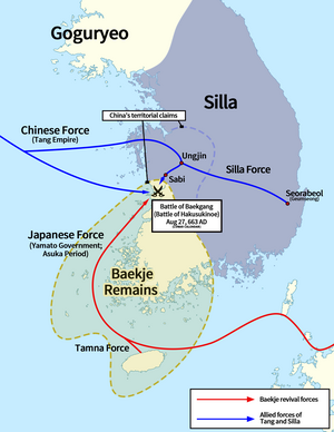
The Battle of Baekgang (Korean: 백강 전투; Hanja: 白江戰鬪) or Battle of Baekgang-gu, also known as the Battle of Hakusukinoe (Japanese: 白村江の戦い, romanized: Hakusuki-no-e no Tatakai / Hakusonkō no Tatakai) in Japan, and as the Battle of Baijiangkou (Chinese: 白江口之战; Chinese: 白江口之戰; pinyin: Bāijiāngkǒu Zhīzhàn) in China, was a battle between Baekje restoration forces and their ally, Yamato Japan, against the allied forces of Silla and Tang China. The battle took place in the Baengma River (Korean: 백마강; Hanja: 白馬江) or Baek River (Korean: 백강; Hanja: 白江), which is the lower reach of the Geum River in Jeollabuk-do province, Korea. The Silla-Tang forces won a decisive victory, compelling Yamato Japan to withdraw completely from Korean affairs and crushing the Baekje restoration movement.

USS LST-849
US Navy tank landing ship
Distance: Approx. 709 meters
Latitude and longitude: 35.98966,126.71716
USS LST-849 was an LST-542-class tank landing ship in the United States Navy during World War II. Late in her U.S. Navy career, she was renamed Johnson County (LST-849)—after counties in Arkansas, Georgia, Illinois, Indiana, Iowa, Kansas, Kentucky, Missouri, Nebraska, Tennessee, Texas, and Wyoming—but never saw active service under that name. LST-849 was laid down on 10 November 1944 at Ambridge, Pennsylvania, by the American Bridge Co.; launched on 30 December 1944; sponsored by Mrs. William B. Hetzel; and commissioned on 16 January 1945.
Wolmyeong Baseball Stadium
Baseball stadium in Gunsan, South Korea
Distance: Approx. 3415 meters
Latitude and longitude: 35.96602778,126.74802778
Wolmyeong Baseball Stadium is a baseball stadium in Gunsan, South Korea.

Port of Gunsan
Port in South Korea
Distance: Approx. 2391 meters
Latitude and longitude: 36,126.7
The Port of Gunsan(Korean: 군산항; Hanja: 群山港) is a port in South Korea, located in the city of Gunsan, North Jeolla Province.

Port of Janghang
Port in South Korea
Distance: Approx. 2391 meters
Latitude and longitude: 36,126.7
The Port of Janghang is a port in South Korea, located in the county of Seocheon. It is situated at the mouth of the Geum River, at the eastern extremity of the limits of the Port of Gunsan.

Wolmyeong Park
Park in Gunsan, South Korea
Distance: Approx. 2240 meters
Latitude and longitude: 35.981,126.692
Wolmyeong Park (Korean: 월명공원; lit. Bright Moon Park), also Wolmyeongdong Park, is a park in Gunsan, South Korea. It is located at the intersection of five mountains.

Leesungdang
Oldest bakery in South Korea
Distance: Approx. 651 meters
Latitude and longitude: 35.9871,126.7112
Leesungdang (Korean: 이성당; Hanja: 李盛堂) is a historic bakery in Gunsan, North Jeolla Province, South Korea. It is the oldest active bakery in South Korea, having been founded in 1945, just after the liberation of Korea. It has remained a family business since then, and by 2019 was operated by the daughter-in-law of the founder.
Weather in this IP's area
mist
-1 Celsius
-8 Celsius
-1 Celsius
-1 Celsius
1017 hPa
93 %
1017 hPa
1015 hPa
4023 meters
10.29 m/s
12.86 m/s
310 degree
75 %