106.0.36.67 - IP Lookup: Free IP Address Lookup, Postal Code Lookup, IP Location Lookup, IP ASN, Public IP
Country:
 India
IndiaRegion:
City:
Location:
Time Zone:
Postal Code:
ISP:
ASN:
language:
User-Agent:
Proxy IP:
Blacklist:
IP information under different IP Channel
ip-api
Country
Region
City
ASN
Time Zone
ISP
Blacklist
Proxy
Latitude
Longitude
Postal
Route
db-ip
Country
Region
City
ASN
Time Zone
ISP
Blacklist
Proxy
Latitude
Longitude
Postal
Route
IPinfo
Country
Region
City
ASN
Time Zone
ISP
Blacklist
Proxy
Latitude
Longitude
Postal
Route
IP2Location
106.0.36.67Country
inRegion
telangana
City
alampur
Time Zone
Asia/Kolkata
ISP
Language
User-Agent
Latitude
Longitude
Postal
ipdata
Country
Region
City
ASN
Time Zone
ISP
Blacklist
Proxy
Latitude
Longitude
Postal
Route
Popular places and events near this IP address
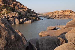
Tungabhadra River
River in southern India
Distance: Approx. 1628 meters
Latitude and longitude: 15.88861111,78.16416667
The Tungabhadra River (Kannada: [t̪uŋɡɐbʱɐd̪rɐ]) starts and flows through the state of Karnataka, India, during most of its course, then through Andhra Pradesh, and ultimately joins the Krishna River near Murvakonda in Andhra Pradesh. The river Tungabhadra derives its name from two streams, the Tunga, about 147 km (91 mi) long, and the Bhadra, about 178 km (111 mi) long, which rise in the Western Ghats(Sahyadri mountains). The river after the confluence of the two streams in Koodali near Shimoga runs for about 531 km (330 mi) till it joins the river Krishna at Sangamaleshwaram in Andhra Pradesh.

Alampuram (Hemalapuram)
Mandal in Telangana, India
Distance: Approx. 2016 meters
Latitude and longitude: 15.878,78.132
Alampuram (Hemalapuram) is a town situated in Jogulamba Gadwal district in the Indian state of Telangana. Alampur is a popular Hindu pilgrimage site in Shaktism and is also home to the Navabrahma Temples, a group of nine temples dedicated to Shiva built in the seventh and eighth century CE. It is the meeting point of the rivers Tungabhadra and Krishna and is referred to as Dakshina Kasi and is also considered the western gateway to Srisailam. The sacredness of Alampur is mentioned in the Skanda Purana.

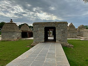
Alampur Navabrahma Temples
Hindu temples in India dating from the 7th and 9th centuries
Distance: Approx. 1735 meters
Latitude and longitude: 15.87780556,78.13483333
Alampuram Navabrahma Temples are a group of nine early Badami Chalukyan Hindu temples dated between the 7th and 9th centuries that are located at Alampuram (Hemalapuram) in Telangana, India, near the meeting point of Tungabhadra River and Krishna River at the border of Andhra Pradesh. They are called Nava-Brahma temples though they are dedicated to Shiva. They exemplify early North Indian Nagara style architecture with cut rock as the building block.

Handri-Neeva
River in India
Distance: Approx. 9583 meters
Latitude and longitude: 15.90861111,78.23555556
Handri-Neeva Sujala Sravanthi project is the longest water canal project in the region of Rayalaseema, Andhra Pradesh, India. The project was conceived to provide a reliable irrigation and drinking water supply for the region through drawing flood waters from the Srisailam reservoir. The first phase of the canal begins at Malyala and irrigates six lakh acres in four districts of Rayalaseema, while the second phase provides irrigation facilities and drinking water for Chittoor district.
Alampur Assembly constituency
Constituency of the Telangana legislative assembly in India
Distance: Approx. 2173 meters
Latitude and longitude: 15.88,78.13
Alampur Assembly constituency is a constituency of Telangana Legislative Assembly, India. It is one of 14 constituencies in Mahbubnagar district. It is part of Nagarkurnool Lok Sabha constituency.
Alampur Museum
Archaeological museum in Alampur, India
Distance: Approx. 1735 meters
Latitude and longitude: 15.8776398,78.134898
Alampur ASI Museum is a museum located in the historical temple town of Alampur, Mahbubnagar in Telangana. Situated at the Navabrahma Temples it is maintained by Archaeological Survey of India.
Alampur Papanasi Temples
Distance: Approx. 3177 meters
Latitude and longitude: 15.87147222,78.123
Alampuram Papanasi Temples are a group of twenty three Hindu temples dated between 9th- and 11th-century that have been relocated to the southwest of Alampuram village in Telangana. This cluster of mostly ruined temples are co-located near the meeting point of Tungabhadra River and Krishna River at the border of Andhra Pradesh. They are about 1.5 kilometers from the Alampur Navabrahma Temples of the Shaivism tradition, but completed a few centuries later by the Rashtrakutas and later Chalukyas.

Jogulamba Temple, Alampur
Hindu temple in India
Distance: Approx. 2051 meters
Latitude and longitude: 15.877,78.132
Jogulamba temple is a Hindu temple dedicated to Goddess Jogulamba, a form of Shakti located in Alampuram, Telangana, India. The temple is one of the Maha Shakti Peethas, a group of eighteen (Ashtadasa) temples considered the most significant shrines and pilgrimage destinations in Shaktism. Alampur is located on the banks of the Tungabhadra river near its confluence with Krishna river.
Jogulamba Barrage
Dam in Peddamandadi mandal of Wanaparthy district
Distance: Approx. 8949 meters
Latitude and longitude: 15.96361111,78.14638889
Jogulamba Barrage is a proposed barrage across Krishna River with full pond level (FPL) 274m. It would be located at Veltoor village, Peddamandadi mandal, Wanaparthy district, Telangana, India. This barrage is proposed to divert 3 TMC of water via lift to Yedula Reservoir being built as part of Palamuru-Rangareddy Lift Irrigation Scheme.
Weather in this IP's area
clear sky
25 Celsius
25 Celsius
25 Celsius
25 Celsius
1012 hPa
42 %
1012 hPa
978 hPa
10000 meters
2.41 m/s
2.94 m/s
130 degree
5 %