Country:
Region:
City:
Latitude and Longitude:
Time Zone:
Postal Code:
IP information under different IP Channel
ip-api
Country
Region
City
ASN
Time Zone
ISP
Blacklist
Proxy
Latitude
Longitude
Postal
Route
Luminati
Country
ASN
Time Zone
Africa/Casablanca
ISP
MAROCCONNECT
Latitude
Longitude
Postal
IPinfo
Country
Region
City
ASN
Time Zone
ISP
Blacklist
Proxy
Latitude
Longitude
Postal
Route
db-ip
Country
Region
City
ASN
Time Zone
ISP
Blacklist
Proxy
Latitude
Longitude
Postal
Route
ipdata
Country
Region
City
ASN
Time Zone
ISP
Blacklist
Proxy
Latitude
Longitude
Postal
Route
Popular places and events near this IP address

Meknes
City in Fès-Meknès, Morocco
Distance: Approx. 6374 meters
Latitude and longitude: 33.895,-5.55472222
Meknes (Arabic: مكناس, romanized: maknās, pronounced [maknaːs]) is one of the four Imperial cities of Morocco, located in northern central Morocco and the sixth largest city by population in the kingdom. Founded in the 11th century by the Almoravids as a military settlement, Meknes became the capital of Morocco during the reign of Sultan Ismail Ibn Sharif (1672–1727), son of the founder of the Alaouite dynasty. Sultan Ismail created a massive imperial palace complex and endowed the city with extensive fortifications and monumental gates.

Meknès-Tafilalet
Region in Morocco
Distance: Approx. 6541 meters
Latitude and longitude: 33.88333333,-5.55
Meknès-Tafilalt (Arabic: مكناس تافيلالت (Meknes-Tafilelt)) was one of the sixteen former regions of Morocco that existed from 1997 to 2015. It was situated in north-central Morocco, bordering Algeria. It covered an area of 79,210 km² and record a population of 2,316,865 in the 2014 census.

Honneur Stadium (Meknes)
Multi-purpose stadium in Rabat, Morocco
Distance: Approx. 5249 meters
Latitude and longitude: 33.891534,-5.539577
Honneur Stadium is a multi-use stadium in Meknes, Morocco. It is currently used mostly for football matches and hosts the home games of COD Meknès. The stadium holds 25,000 people.
Meknès Prefecture
Distance: Approx. 6372 meters
Latitude and longitude: 33.895,-5.5547
Meknès Prefecture is a prefecture in the Fès-Meknès region of Morocco. It was created from the former prefectures of Meknès-El Menzeh and Al Ismaïlia.
Bassatine Air Base
Airport in Meknes, Morocco
Distance: Approx. 4538 meters
Latitude and longitude: 33.87916667,-5.515
Bassatine Air Base (IATA: MEK, ICAO: GMFM) is a military air base in Meknes, Morocco. It is also known as the Second Royal Air Force Base, operated by the Royal Moroccan Air Force.
Al Machouar – Stinia
Municipality and town in Fès-Meknès, Morocco
Distance: Approx. 7165 meters
Latitude and longitude: 33.8915,-5.5623
Al Machouar – Stinia is a town and municipality in Meknès Prefecture of the Fès-Meknès region of Morocco. At the time of the 2004 census, the commune had a total population of 5387 people living in 1327 households.
Ouislane
Municipality and town in Fès-Meknès, Morocco
Distance: Approx. 474 meters
Latitude and longitude: 33.9107,-5.4866
Ouislane (Berber: Wislan) is a town and municipality in Meknès Prefecture of the Fès-Meknès region of Morocco. The 2014 Moroccan census recorded a population of 87,910. At the time of the 2004 census, the commune had a total population of 47,824 people living in 9327 households.
Dkhissa
Rural commune and town in Fès-Meknès, Morocco
Distance: Approx. 3349 meters
Latitude and longitude: 33.9373,-5.4666
Dkhissa is a small town and rural commune in Meknès Prefecture of the Fès-Meknès region of Morocco. At the time of the 2004 census, the commune had a total population of 13,541 people living in 2,476 households.
Sidi Slimane Moul Al Kifane
Rural commune and town in Fès-Meknès, Morocco
Distance: Approx. 6522 meters
Latitude and longitude: 33.8605,-5.4612
Sidi Slimane Moul Al Kifane is a small town and rural commune in Meknès Prefecture of the Fès-Meknès region of Morocco. At the time of the 2004 census, the commune had a total population of 15136 people living in 2769 households.

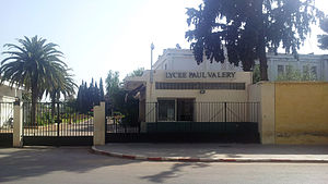
Lycée Paul Valéry (Morocco)
Distance: Approx. 5377 meters
Latitude and longitude: 33.8894,-5.5397
Lycée Paul Valéry (LPV) is a French international school in Meknès, Morocco. It serves levels maternelle (preschool) through lycée (senior high school). It is named after the French poet Paul Valéry.

Moulay Ismail University
Distance: Approx. 6374 meters
Latitude and longitude: 33.895,-5.55472222
Moulay Ismail University (French: Université Moulay Ismail; Arabic: جامعة مولاي إسماعيل) is a university in Meknes city, Morocco, which was founded in 1989. It is named after the Moroccan Sultan Moulay Ismaïl.

Lalla Aouda Mosque
Mosque in Meknes, Morocco
Distance: Approx. 7029 meters
Latitude and longitude: 33.89305556,-5.56141667
The Lalla Aouda Mosque or Mosque of Lalla 'Awda (Arabic: مسجد لالة عودة, romanized: masjid lalla 'awda; Berber languages: ⵎⴻⵣⴳⵉⴷⴰ ⵍⴰⵍⴰ ⵄⴰⵡⴷⴰ, romanized: mezgita lalla 'awda) is a large historic mosque in Meknes, Morocco. It was originally the mosque of the Marinid kasbah (citadel) of the city, built in 1276, but was subsequently remodeled into the royal mosque of the Alaouite sultan Moulay Isma'il's imperial palace in the late 17th century.
Weather in this IP's area
few clouds
19 Celsius
19 Celsius
19 Celsius
20 Celsius
1014 hPa
52 %
1014 hPa
954 hPa
10000 meters
2.06 m/s
30 degree
20 %
07:53:45
18:19:21