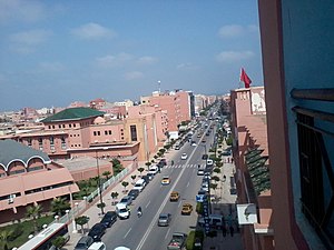
Country:
Region:
City:
Latitude and Longitude:
Time Zone:
Postal Code:
IP information under different IP Channel
ip-api
Country
Region
City
ASN
Time Zone
ISP
Blacklist
Proxy
Latitude
Longitude
Postal
Route
Luminati
Country
ASN
Time Zone
Africa/Casablanca
ISP
MAROCCONNECT
Latitude
Longitude
Postal
IPinfo
Country
Region
City
ASN
Time Zone
ISP
Blacklist
Proxy
Latitude
Longitude
Postal
Route
db-ip
Country
Region
City
ASN
Time Zone
ISP
Blacklist
Proxy
Latitude
Longitude
Postal
Route
ipdata
Country
Region
City
ASN
Time Zone
ISP
Blacklist
Proxy
Latitude
Longitude
Postal
Route
Popular places and events near this IP address

Beni Mellal
Place in Béni Mellal-Khénifra, Morocco
Distance: Approx. 1065 meters
Latitude and longitude: 32.33944444,-6.36083333
Beni Mellal (Arabic: بني ملال) is a city in north-central Morocco. It is the capital of the Béni Mellal-Khénifra Region and has a population of 192,676 (2014 census). It sits at the foot of Jbel Tassemit (2247 m), next to the plains of Beni Amir.

Tadla-Azilal
Region in Morocco
Distance: Approx. 431 meters
Latitude and longitude: 32.33333333,-6.35
Tadla-Azilal (Arabic: تادلة أزيلال) was formerly one of the sixteen regions of Morocco from 1997 to 2015. It was situated in central Morocco. It covered an area of 17,125 km2 and had a population of 1,607,509 (2014 census).

Béni-Mellal Province
Distance: Approx. 1065 meters
Latitude and longitude: 32.33944444,-6.36083333
Béni-Mellal (Arabic: بني ملال) is a province in the Moroccan region of Béni Mellal-Khénifra. Its population in 2004 was 946,018.
Oulad Yaich
Town in Béni Mellal-Khénifra, Morocco
Distance: Approx. 8985 meters
Latitude and longitude: 32.4167,-6.33333
Oulad Yaich is a town in Béni-Mellal Province, Béni Mellal-Khénifra, Morocco. According to the 2004 census, it has a population of 7,692. The town known for its meat and its exceedingly hot summer weather.
Sidi Jaber
Town in Béni Mellal-Khénifra, Morocco
Distance: Approx. 8116 meters
Latitude and longitude: 32.38333333,-6.41666667
Sidi Jaber is a town in Béni-Mellal Province, Béni Mellal-Khénifra, Morocco. According to the 2004 census it has a population of 4,693.
Battle of Tadla
Battle in 1554
Distance: Approx. 431 meters
Latitude and longitude: 32.33333333,-6.35
The Battle of Tadla occurred in September 1554 in Tadla, Morocco, between Ali Abu Hassun, last ruler of the Wattasid dynasty, and Mohammed ash-Sheikh, ruler of the Saadis.
Foum Oudi
Rural commune and town in Béni Mellal-Khénifra, Morocco
Distance: Approx. 9884 meters
Latitude and longitude: 32.2777,-6.4278
Foum Oudi is a town and rural commune in Béni Mellal Province, Béni Mellal-Khénifra, Morocco. At the time of the 2004 census, the commune had a total population of 7802 people living in 1404 households.
Foum El Anceur
Rural commune and town in Béni Mellal-Khénifra, Morocco
Distance: Approx. 9173 meters
Latitude and longitude: 32.3718,-6.2613
Foum El Anceur is a town and rural commune in Béni Mellal Province, Béni Mellal-Khénifra, Morocco. At the time of the 2004 census, the commune had a total population of 13,795 people living in 2590 households.
Ait Abbas
Rural commune and town in Tadla-Azilal, Morocco
Distance: Approx. 431 meters
Latitude and longitude: 32.333333,-6.35
Ait Abbas is a small town and rural commune in Azilal Province of the Tadla-Azilal region of Morocco. At the time of the 2004 census, the commune had a total population of 10,391 people living in 1,460 households.
Oulad Ayyad
Commune in Taza-Al Hoceima-Taounate, Morocco
Distance: Approx. 3181 meters
Latitude and longitude: 32.33333333,-6.38333333
Oulad Ayyad is a commune in the Taounate Province of the Taza-Al Hoceima-Taounate administrative region of Morocco. At the time of the 2004 census, the commune had a total population of 8896 people living in 1386 households.
Beni Mellal Airport
Airport
Distance: Approx. 7655 meters
Latitude and longitude: 32.4,-6.31666667
Beni Mellal Airport (IATA: BEM, ICAO: GMMD) is an airport serving Beni Mellal, Morocco opened in 2014. The airport is located near the township of Oulad Yaich.

Tassemit
Mountain in Béni Mellal-Khénifra, Morocco
Distance: Approx. 9402 meters
Latitude and longitude: 32.30393056,-6.25796944
Tassemit or Jbel Tassemit (Berber languages: ⴰⴷⵔⴰⵔ ⵏ ⵓⴽⵍⵉⵎ), is a mountain of the Béni Mellal-Khénifra region of Morocco. Its altitude is 2,205 m. It is in the High Atlas not far from Beni Mellal, Beni Mellal Province.
Weather in this IP's area
clear sky
21 Celsius
20 Celsius
21 Celsius
21 Celsius
1013 hPa
37 %
1013 hPa
952 hPa
10000 meters
3.09 m/s
320 degree
07:54:13
18:25:46