Country:
Region:
City:
Latitude and Longitude:
Time Zone:
Postal Code:
IP information under different IP Channel
ip-api
Country
Region
City
ASN
Time Zone
ISP
Blacklist
Proxy
Latitude
Longitude
Postal
Route
Luminati
Country
ASN
Time Zone
Africa/Casablanca
ISP
MAROCCONNECT
Latitude
Longitude
Postal
IPinfo
Country
Region
City
ASN
Time Zone
ISP
Blacklist
Proxy
Latitude
Longitude
Postal
Route
db-ip
Country
Region
City
ASN
Time Zone
ISP
Blacklist
Proxy
Latitude
Longitude
Postal
Route
ipdata
Country
Region
City
ASN
Time Zone
ISP
Blacklist
Proxy
Latitude
Longitude
Postal
Route
Popular places and events near this IP address

Stade Mohammed V
Multi-purpose stadium in Casablanca, Morocco
Distance: Approx. 1030 meters
Latitude and longitude: 33.58277778,-7.64694444
The Mohammed V Stadium (Arabic: ملعب محمد الخامس, French: Stade Mohammed V) is a multi-purpose stadium which is part of the Mohammed V Athletic Complex (المركب الرياضي محمد الخامس) which is named after King Mohammed V and situated at the heart of Casablanca, Morocco, in the western part of the Maârif neighborhood. The stadium has a seating capacity of 45,891, and is the oldest football stadium in Morocco. It primarily hosts association football matches, serving as the home ground of the Morocco national football team and local rival football clubs Wydad AC and Raja CA. In 1997, the stadium set a record of attendance of 110,000 during the Casablanca football derby and a match between the Moroccan national team against Ghana.
Anfa
District of Casablanca in Casablanca-Settat, Morocco
Distance: Approx. 388 meters
Latitude and longitude: 33.58833333,-7.64194444
Anfa (Berber language: Anfa or Anaffa, ⴰⵏⴼⴰ; Arabic: أنفا; Spanish: Anafe; Portuguese: Anafé) was the ancient toponym for Casablanca during the classical period. The city was founded by Berbers around the 10th century BC, with the Romans under Augustus later establishing the commercial port of "Anfus" in 15 BC. Anfa is now the name of a district in the oldest part of Casablanca, located in the Casablanca-Settat region of Morocco. The district covers an area of 37.5 square kilometres (14.5 square miles), and as of 2004 had 492,787 inhabitants.

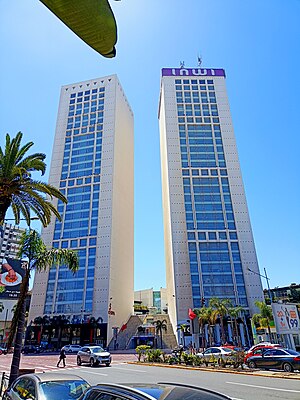
Casablanca Twin Center
Complex of two skyscrapers in Casablanca, Morocco
Distance: Approx. 581 meters
Latitude and longitude: 33.58611111,-7.63194444
The Casablanca Twin Center (Arabic: برجا الدار البيضاء) is a complex of two skyscrapers located at Casablanca, Morocco. The two structures, the West Tower and the East Tower, have 28 floors each. The center houses a complex of shops, offices, and a five-star hotel, and lies at the heart of Casablanca in the Maarif district, at the crossroads between Zerktouni Boulevard and the Boulevard Al Massira Al Khadra.
Lycée Lyautey (Casablanca)
Private school in Casablanca, Morocco
Distance: Approx. 927 meters
Latitude and longitude: 33.596,-7.635
Lycée Lyautey is a French institution of secondary education located in Casablanca, Morocco. It is composed of a collège (middle school) and a lycée (high school), and belongs to the Académie de Bordeaux, an educational administrative district in France. The school was named after Marshal Louis Hubert Gonzalve Lyautey, who was the first French resident general in Morocco from 1912 to 1925, at the beginning of the French protectorate in Morocco.
Salle Mohammed V
Distance: Approx. 1073 meters
Latitude and longitude: 33.580715,-7.645363
Salle Mohamed V is an indoor sporting arena located in Casablanca, Morocco. The capacity of the arena is 12,000 people.
Complexe Al Amal
Distance: Approx. 1108 meters
Latitude and longitude: 33.588134,-7.625837
The Complexe Al Amal is a tennis complex in Casablanca, Morocco. The complex is the host of the annual ATP Tour stop, the Grand Prix Hassan II. The stadium court has a capacity of 5,500 people.

Temple Beth-El (Casablanca)
Orthodox synagogue in Casablanca, Morocco
Distance: Approx. 1238 meters
Latitude and longitude: 33.59681667,-7.62965
The Temple Beth-El (Hebrew: בית הכנסת בית־אל, romanized: Béit hak'néset Bēṯ-ʾEl, lit. 'Synagogue of the House of God'; Arabic: معبد بيت إيل, romanized: Maʿbad bayt ʾĪl, lit. 'Temple of the House of El') is an Orthodox Jewish congregation and synagogue, located at 67 Rue Jaber ben Hayane, in the Sidi Belyout district of Casablanca, Morocco.
Sidi Belyout
Arrondissement of Casablanca in Casablanca-Settat, Morocco
Distance: Approx. 399 meters
Latitude and longitude: 33.58444444,-7.63722222
Sidi Belyout (Arabic: سيدي بليوط) is an arrondissement of Casablanca, in the Anfa district of the Casablanca-Settat region of Morocco. As of 2004 it had 218,918 inhabitants.
Bourgogne (Casablanca)
Quartier in Casablanca
Distance: Approx. 1239 meters
Latitude and longitude: 33.599,-7.6398
Bourgogne is a quartier of Casablanca, Morocco.
Maârif
Arrondissement of Casablanca in Casablanca-Settat, Morocco
Distance: Approx. 399 meters
Latitude and longitude: 33.58444444,-7.63722222
Maârif or El Maârif (Arabic: المعاريف, lit. 'the notables') is a neighborhood of Casablanca, in the Anfa district of the Casablanca-Settat region of Morocco. As of 2004 it had 180,394 inhabitants.
Anfa (arrondissement)
Arrondissement of Casablanca in Casablanca-Settat, Morocco
Distance: Approx. 388 meters
Latitude and longitude: 33.58833333,-7.64194444
Anfa (Arabic: أنفا) is an arrondissement of Casablanca, in the Anfa district of the Casablanca-Settat region of Morocco. As of 2004 it had 95,539 inhabitants.
Scuola "Enrico Mattei"
Italian international school
Distance: Approx. 765 meters
Latitude and longitude: 33.5909,-7.6303
Scuola "Enrico Mattei" (French: École italienne Enrico Mattei, Arabic: مدرسة إنريكو ماتي) is a private Italian international school in Morocco which is headquartered in Casablanca. The main campus in Casablanca includes preschool, primary school, lower secondary school, and upper secondary school. There is also a branch school in Tangier.
Weather in this IP's area
few clouds
19 Celsius
19 Celsius
19 Celsius
20 Celsius
1013 hPa
68 %
1013 hPa
1009 hPa
10000 meters
5.14 m/s
300 degree
20 %
08:01:43
18:28:34