Country:
Region:
City:
Latitude and Longitude:
Time Zone:
Postal Code:
IP information under different IP Channel
ip-api
Country
Region
City
ASN
Time Zone
ISP
Blacklist
Proxy
Latitude
Longitude
Postal
Route
Luminati
Country
ASN
Time Zone
Africa/Casablanca
ISP
MAROCCONNECT
Latitude
Longitude
Postal
IPinfo
Country
Region
City
ASN
Time Zone
ISP
Blacklist
Proxy
Latitude
Longitude
Postal
Route
db-ip
Country
Region
City
ASN
Time Zone
ISP
Blacklist
Proxy
Latitude
Longitude
Postal
Route
ipdata
Country
Region
City
ASN
Time Zone
ISP
Blacklist
Proxy
Latitude
Longitude
Postal
Route
Popular places and events near this IP address
El Jadida
City in Casablanca-Settat, Morocco
Distance: Approx. 2738 meters
Latitude and longitude: 33.23333333,-8.5
El Jadida (Arabic: الجديدة, romanized: al-Jadīda, [alʒadiːda]) is a major port city on the Atlantic coast of Morocco, located 96 kilometres (60 mi) south of the city of Casablanca, in the province of El Jadida and the region of Casablanca-Settat. It has a population of 170,956 as of 2023. The fortified city, built by the Portuguese at the beginning of the 16th century and named Mazagan (Mazagão in Portuguese), was given up by the Portuguese in 1769 and incorporated into Morocco.

Ben M'Hamed El Abdi Stadium
Distance: Approx. 2223 meters
Latitude and longitude: 33.24164,-8.493274
Ben M'Hamed El Abdi Stadium is a multi-use stadium in El Jadida, Morocco. It is currently used mostly for football matches and hosts the home games of Difaa El Jadida. The stadium holds 15,000 people.
El Jadida Province
Province of Morocco
Distance: Approx. 2738 meters
Latitude and longitude: 33.23333333,-8.5
El Jadida Province (Arabic: الجديدة) is a province of Morocco, located in the region of Casablanca-Settat. The province takes its name from the chief city of El Jadida. Its population in 2006 was 1,128,098.
Moulay Abdallah Amghar
Town in Casablanca-Settat, Morocco
Distance: Approx. 9897 meters
Latitude and longitude: 33.1978,-8.58833
Moulay Abdallah is a town in El Jadida Province, Casablanca-Settat, Morocco. According to the 2004 census it has a population of 6,482. Every year in summer, the town holds the Mawsim of Moulay Abdallah Amghar.
École nationale des sciences appliquées d'El Jadida
Distance: Approx. 979 meters
Latitude and longitude: 33.2488,-8.5132
The École nationale des sciences appliquées d'El Jadida (المدرسة الوطنية للعلوم التطبيقية بالجديدة) is a Moroccan public engineering school located in El Jadida attached to the Chouaïb Doukkali University, and part of the national network of appliedscience schools.

Chouaib Doukkali University
University in El Jadida, Morocco
Distance: Approx. 3938 meters
Latitude and longitude: 33.22638889,-8.48722222
Chouaib Doukkali University is a public university in El Jadida, Morocco, founded by a royal decree (Dahir) in 1985. The university is named after the Moroccan scholar, theologian, and politician Abou Chouaib Doukkali (1878–1937).

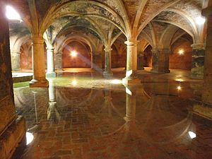
Portuguese Cistern (Mazagan)
Ancient cistern in Morocco
Distance: Approx. 566 meters
Latitude and longitude: 33.25673306,-8.50273806
The Portuguese Cistern is a historic cistern in El Jadida, Morocco. It is located beneath the citadel at the heart of the historic Portuguese fortified city of Mazagan. It is a classified cultural heritage monument in Morocco and, along with the rest of the old walled city, forms part of a UNESCO World Heritage Site.

Siege of Mazagan (1562)
16th c. military action
Distance: Approx. 2738 meters
Latitude and longitude: 33.23333333,-8.5
The siege of Mazagan of 1562, also known as the Great Siege of Mazagan (Portuguese: Grande Cerco de Mazagão) was an armed engagement that took place in the modern city of El Jadida, then known as Mazagan, between Portuguese forces and those of the Saadi dynasty, which had unified Morocco a few years prior. The Moroccans ultimately failed to breach the defenses of the city, and in the face of continuous Portuguese reinforcements and vigorous defence were forced to withdraw after a two and a half month long siege. It was one of the hardest fought sieges withstood by the Portuguese at Mazagan, of a total of nine.

Siege of Mazagan (1769)
Distance: Approx. 2738 meters
Latitude and longitude: 33.23333333,-8.5
The siege of Mazagan of 1769 was the last engagement between Morocco and the Portuguese in Mazagan (El Jadida). The Moroccan army under Sultan Mohammed ben Abdallah was victorious and the Portuguese evacuated their last garrison in Morocco, bringing an end to their 354-year-long conflict.
Weather in this IP's area
broken clouds
19 Celsius
19 Celsius
19 Celsius
19 Celsius
1012 hPa
74 %
1012 hPa
1011 hPa
10000 meters
5.33 m/s
7.08 m/s
230 degree
77 %
08:04:35
18:32:41

