105.203.198.17 - IP Lookup: Free IP Address Lookup, Postal Code Lookup, IP Location Lookup, IP ASN, Public IP
Country:
Region:
City:
Location:
Time Zone:
Postal Code:
ISP:
ASN:
language:
User-Agent:
Proxy IP:
Blacklist:
IP information under different IP Channel
ip-api
Country
Region
City
ASN
Time Zone
ISP
Blacklist
Proxy
Latitude
Longitude
Postal
Route
db-ip
Country
Region
City
ASN
Time Zone
ISP
Blacklist
Proxy
Latitude
Longitude
Postal
Route
IPinfo
Country
Region
City
ASN
Time Zone
ISP
Blacklist
Proxy
Latitude
Longitude
Postal
Route
IP2Location
105.203.198.17Country
Region
al qahirah
City
cairo
Time Zone
Africa/Cairo
ISP
Language
User-Agent
Latitude
Longitude
Postal
ipdata
Country
Region
City
ASN
Time Zone
ISP
Blacklist
Proxy
Latitude
Longitude
Postal
Route
Popular places and events near this IP address

Khedivial Opera House
Former opera house in Cairo, Egypt
Distance: Approx. 1335 meters
Latitude and longitude: 30.0507,31.248
The Khedivial Opera House or Royal Opera House (Arabic: دار الأوبرا الخديوية / ALA-LC: Dār Awbirā al-Khudaywī) was an opera house in Cairo, Egypt, the oldest opera house in all of Africa. It was inaugurated on 1 November 1869 and it burned down on 28 October 1971. The opera house was built on the orders of the Khedive Ismail to celebrate the opening of the Suez Canal.

Ramses Station
Railway station in Egypt
Distance: Approx. 264 meters
Latitude and longitude: 30.06361111,31.24722222
Ramses Railway Station (Arabic: محطة رمسيس, romanized: Maḥaṭṭat Ramsīs), also called Misr Station (Arabic: محطة مصر, romanized: Maḥaṭṭat Miṣr), is the main railway station of Cairo, Egypt. The name is derived from the Ancient Egyptian pharaoh Ramses II, whose statue was erected by Nasser on the square there in 1955.

Azbakeya
Historic district in Cairo, Egypt
Distance: Approx. 1101 meters
Latitude and longitude: 30.05277778,31.24833333
Azbakeya (Arabic: أزبكية; also spelled Al Uzbakeya or Auzbekiya) is one of the districts of the Western Area of Cairo, Egypt. Along with Wust Albalad (Downtown) and Abdeen, Azbakiya forms Cairo's 19th century expansion outside the medieval city walls known officially as Khedival Cairo and declared as an Area of Value. It holds many historically important buildings and spaces.

Coptic Hospital
Hospital in Cairo, Egypt
Distance: Approx. 274 meters
Latitude and longitude: 30.06305556,31.2525
The Coptic Hospital (Arabic:المستشفى القبطي) is a hospital in Cairo, Egypt.

Faggala
District in Cairo Governorate, Egypt
Distance: Approx. 502 meters
Latitude and longitude: 30.06027778,31.25416667
Faggala (Arabic: الفجّالة) is a district of Cairo, Egypt near Ramesis Square. It is one of the oldest districts in the city. It has long been an important center for book publishing, perhaps the largest in the country.

St. Mary's Coptic Orthodox Church Massarra
Church in Shubra, Egypt
Distance: Approx. 1305 meters
Latitude and longitude: 30.07305,31.24357
St. Mary's Coptic Orthodox Church Massarra is a parish of the Coptic Orthodox Church of Alexandria located in the Shubra District of Cairo, Egypt. The church was built during Pope Cyril V of Alexandria's tenure as Pope of the Coptic Orthodox Church, and consecrated in 1925.
Ets Hayim Synagogue
Former synagogue in Cairo, Egypt
Distance: Approx. 1361 meters
Latitude and longitude: 30.06339,31.2638
The Ets Hayim Synagogue (Hebrew: בית הכנסת עץ חיים (מצרים)), also known as the Etz Haim Synagogue, the Hanan Synagogue, the Baroukh Hanan Synagogue or the Kenisset Hanan (Arabic: كنسة حنان; French: Temple Hanan), is a former Karaite Jewish congregation and synagogue, located at 3 Qantaret Street, in the Ghamra neighborhood of Daher, in Cairo, Egypt. The synagoge was completed in 1900. The congregation worshipped in the Sephardic rite.
Ramses Exchange
Distance: Approx. 1259 meters
Latitude and longitude: 30.066979,31.261744
The Ramses Exchange is a telecoms building in central Cairo that is a focal point of the Internet in Egypt. It is situated at 26 Ramses Street. Reports related to the 2011 Internet shutdown in Egypt refer to the Ramses Exchange as the location where the shut down was effected by powering down parts of the exchange.

Mosque of al-Zahir Baybars
Mosque in Cairo, Egypt
Distance: Approx. 1320 meters
Latitude and longitude: 30.0623,31.2634
The Mosque of al-Zahir Baybars (Arabic: مسجد الظاهر بيبرس) is a mosque built in Cairo, Egypt by the Mamluk Sultan al-Zahir Baybars al-Bunduqdari (r. 1260-1277) through his Vizier Bahaa el-Din bin Hanna and Sanjar al-Shuja‘i.
Bab El Shaariya station
Metro station in Cairo, Egypt
Distance: Approx. 1132 meters
Latitude and longitude: 30.054,31.25597222
Bab El Shaariya (Arabic: محطة باب الشعرية) is a station on Cairo Metro, part of Phase 1 of Line 3. it is located under El-Geish street in Bab El Shaaria Square at the intersection of Port Said street with that street.

Al-Fath Mosque
Mosque in Cairo, Egypt
Distance: Approx. 466 meters
Latitude and longitude: 30.059846,31.246056
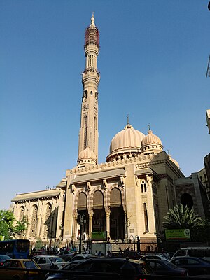
Al-Fath Mosque (Arabic: مسجد الفتح) is a mosque in the city of Cairo. Located in the Ramses Square, it is among the largest mosques and equips the tallest minaret in the city and the 3rd tallest in the world. During the post-coup unrest in Egypt, the Second Ramses Incident took place in the mosque on August 16, 2013, which resulted in the death and injury of several protesters and subsequent shut down of the mosque.
Ramses Station rail disaster
Train accident in Egypt on 27 February 2019
Distance: Approx. 297 meters
Latitude and longitude: 30.06305556,31.24666667
The Ramses Station rail disaster occurred on 27 February 2019 in Ramses Station of Cairo, Egypt. Twenty-five people were killed and forty injured.
Weather in this IP's area
clear sky
15 Celsius
15 Celsius
15 Celsius
15 Celsius
1019 hPa
72 %
1019 hPa
1014 hPa
10000 meters
4.12 m/s
120 degree