104.37.145.7 - IP Lookup: Free IP Address Lookup, Postal Code Lookup, IP Location Lookup, IP ASN, Public IP
Country:
 USA
USARegion:
City:
Location:
Time Zone:
Postal Code:
ISP:
ASN:
language:
User-Agent:
Proxy IP:
Blacklist:
IP information under different IP Channel
ip-api
Country
Region
City
ASN
Time Zone
ISP
Blacklist
Proxy
Latitude
Longitude
Postal
Route
db-ip
Country
Region
City
ASN
Time Zone
ISP
Blacklist
Proxy
Latitude
Longitude
Postal
Route
IPinfo
Country
Region
City
ASN
Time Zone
ISP
Blacklist
Proxy
Latitude
Longitude
Postal
Route
IP2Location
104.37.145.7Country
usRegion
pennsylvania
City
montoursville
Time Zone
America/New_York
ISP
Language
User-Agent
Latitude
Longitude
Postal
ipdata
Country
Region
City
ASN
Time Zone
ISP
Blacklist
Proxy
Latitude
Longitude
Postal
Route
Popular places and events near this IP address
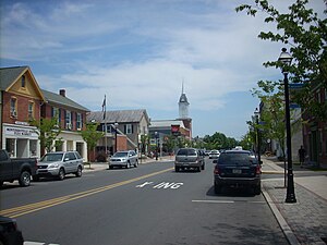
Montoursville, Pennsylvania
Borough in Pennsylvania, United States
Distance: Approx. 807 meters
Latitude and longitude: 41.25277778,-76.91555556
Montoursville is a borough in Lycoming County, Pennsylvania. The 2020 census reported its population as 4,745. It forms part of the Williamsport, Pennsylvania Metropolitan Statistical Area.

Williamsport Regional Airport
Commercial airport in Williamsport, Pennsylvania
Distance: Approx. 1537 meters
Latitude and longitude: 41.24166667,-76.92166667
Williamsport Regional Airport (IATA: IPT, ICAO: KIPT, FAA LID: IPT) serves Williamsport, Pennsylvania, and the surrounding area with a population of roughly 200,000. The airport processes approximately 40,000 passengers annually and has served north central Pennsylvania since 1929. Located five miles east of Williamsport, in Lycoming County, Pennsylvania, this airport has two runways, 9/27 and 12/30, both asphalt.

Loyalsock Creek
River in Pennsylvania, United States
Distance: Approx. 2272 meters
Latitude and longitude: 41.238,-76.939
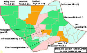
Loyalsock Creek is a 64-mile-long (103 km) tributary of the West Branch Susquehanna River located chiefly in Sullivan and Lycoming counties in Pennsylvania in the United States. As the crow flies, Lycoming County is about 130 miles (209 km) northwest of Philadelphia and 165 miles (266 km) east-northeast of Pittsburgh.

Elk Creek (Loyalsock Creek tributary)
Distance: Approx. 2735 meters
Latitude and longitude: 41.23481,-76.94264
Elk Creek is an 11.4-mile-long (18.3 km) tributary of Loyalsock Creek in Sullivan County, Pennsylvania in the United States. Elk Creek joins Loyalsock Creek several miles below Forksville.
Loyalsock Township High School
Public school in Loyalsock Township, Pennsylvania, United States
Distance: Approx. 3625 meters
Latitude and longitude: 41.2608,-76.9673
Loyalsock Township High School (Grades 9–12) is a medium-sized, suburban high school located in Loyalsock Township, Pennsylvania (near the city of Williamsport). As of the 2016–2017 school year, the school reported an enrollment of 597 pupils in grades 9th through 12th. The mascot for the school is the Lancer, and the school's colors are Maroon, White and Carolina blue.
Mill Creek (Loyalsock Creek tributary)
Distance: Approx. 2726 meters
Latitude and longitude: 41.233897,-76.940426
Mill Creek is the name of four different tributaries of Loyalsock Creek in Lycoming and Sullivan counties in Pennsylvania in the United States. There are two more streams named "Mill Creek" in the Loyalsock Creek drainage basin and one named "Mill Run".

Canfield Island Site
United States historic place
Distance: Approx. 2791 meters
Latitude and longitude: 41.24222222,-76.95305556
The Canfield Island Site, also known as Archeological Site 36LY37, is an archaeological site in Lycoming County, Pennsylvania, United States. Located on Canfield Island in the West Branch Susquehanna River,: 7 the site lies east of the city of Williamsport in Loyalsock Township. It is believed to have been inhabited by prehistoric Native Americans for thousands of years, with the oldest discoveries dating back to more than one millennium before Christ.
Kenmar, Pennsylvania
Census-designated place in Pennsylvania, United States
Distance: Approx. 2901 meters
Latitude and longitude: 41.25333333,-76.95916667
Kenmar is a census-designated place (CDP) in Loyalsock Township, Lycoming County, Pennsylvania, United States. As of the 2010 census, it had a population of 4,124. Kenmar is not a separately incorporated community, but is a part of Loyalsock Township (which is a municipality under Pennsylvania law).

Montoursville Area High School
Public school in Montoursville, Lycoming County, Pennsylvania, United States
Distance: Approx. 753 meters
Latitude and longitude: 41.25,-76.919
Montoursville Area High School is a small suburban/rural public high school located at 100 North Arch Street, Montoursville, Pennsylvania. It is the sole high school operated by the Montoursville Area School District. The school serves the borough of Montoursville, plus the townships of Fairfield, Upper Fairfield, Eldred, Gamble, Cascade, and Plunketts Creek.

Allegheny Airlines Flight 371
1959 aviation accident
Distance: Approx. 3508 meters
Latitude and longitude: 41.22558056,-76.91068056
Allegheny Airlines Flight 371 was a scheduled passenger flight on December 1, 1959, between Philadelphia, Pennsylvania and Cleveland, Ohio with stops in Pennsylvania at Harrisburg, Williamsport, Bradford, and Erie. The Martin 2-0-2 operating the flight departed Harrisburg with 26 passengers and crew on board and crashed while maneuvering to land at Williamsport Regional Airport in poor weather. A passenger was the sole survivor.

Kathryn Wentzel Lumley Aviation Center
Building in Montoursville, Pennsylvania
Distance: Approx. 1081 meters
Latitude and longitude: 41.245708,-76.9226
The Kathryn Wentzel Lumley Aviation Center abbreviated as KWLAC and KWL Aviation Center, is a private college aviation center in the United States. A branch of the Pennsylvania College of Technology, which focuses on aeronautical studies, this center is located roughly seven miles from the college's main campus, on the grounds of Williamsport Regional Airport in Montoursville, Pennsylvania. Plans for the center were announced in 1991.
Kenneth M. Robbins Stadium
Distance: Approx. 3399 meters
Latitude and longitude: 41.2621,-76.9642
Kenneth M. Robbins Stadium (formerly Lancer Stadium) is an outdoor multi-purpose stadium in Loyalsock Township, Pennsylvania near Williamsport in North Central Pennsylvania, United States. The stadium currently is home to the Loyalsock Lancers football boys' and girls' soccer teams. It is owned and operated by the Loyalsock Township School District.
Weather in this IP's area
clear sky
-9 Celsius
-14 Celsius
-10 Celsius
-8 Celsius
1034 hPa
70 %
1034 hPa
997 hPa
10000 meters
3.09 m/s
90 degree