104.36.93.232 - IP Lookup: Free IP Address Lookup, Postal Code Lookup, IP Location Lookup, IP ASN, Public IP
Country:
Region:
City:
Location:
Time Zone:
Postal Code:
IP information under different IP Channel
ip-api
Country
Region
City
ASN
Time Zone
ISP
Blacklist
Proxy
Latitude
Longitude
Postal
Route
Luminati
Country
Region
in
City
batesville
ASN
Time Zone
America/Indiana/Indianapolis
ISP
GREAT-PLAINS-COMMUNICATIONS
Latitude
Longitude
Postal
IPinfo
Country
Region
City
ASN
Time Zone
ISP
Blacklist
Proxy
Latitude
Longitude
Postal
Route
IP2Location
104.36.93.232Country
Region
indiana
City
oldenburg
Time Zone
America/Indiana/Indianapolis
ISP
Language
User-Agent
Latitude
Longitude
Postal
db-ip
Country
Region
City
ASN
Time Zone
ISP
Blacklist
Proxy
Latitude
Longitude
Postal
Route
ipdata
Country
Region
City
ASN
Time Zone
ISP
Blacklist
Proxy
Latitude
Longitude
Postal
Route
Popular places and events near this IP address

Oldenburg, Indiana
Town in Indiana, United States
Distance: Approx. 5660 meters
Latitude and longitude: 39.33888889,-85.20416667
Oldenburg is a town in Ray Township, Franklin County, Indiana, United States. The population was 674 at the 2010 census.
Batesville High School (Indiana)
Public high school in Batesville, Indiana, United States
Distance: Approx. 7801 meters
Latitude and longitude: 39.310942,-85.234165
Batesville High School (BHS) is a public high school in Batesville, Indiana. The high school is part of the Batesville Community School Corporation and has an enrollment of 715.

Ray Township, Franklin County, Indiana
Township in Indiana, United States
Distance: Approx. 5902 meters
Latitude and longitude: 39.32777778,-85.24166667
Ray Township is one of thirteen townships in Franklin County, Indiana. As of the 2020 census, its population was 4,314, up from 4,021 at 2010.

Salt Creek Township, Franklin County, Indiana
Township in Indiana, United States
Distance: Approx. 3983 meters
Latitude and longitude: 39.41638889,-85.23666667
Salt Creek Township is one of thirteen townships in Franklin County, Indiana. As of the 2020 census, its population was 969, down from 1,004 at 2010.
Saint Maurice, Indiana
Unincorporated community in Indiana, United States
Distance: Approx. 8172 meters
Latitude and longitude: 39.36611111,-85.33444444
Saint Maurice is an unincorporated community in Fugit Township, Decatur County, Indiana, United States.
Buena Vista, Franklin County, Indiana
Unincorporated community in Indiana, United States
Distance: Approx. 6998 meters
Latitude and longitude: 39.43888889,-85.2725
Buena Vista is an unincorporated community in Posey Township, Franklin County, Indiana.
Hamburg, Franklin County, Indiana
Unincorporated community and Census-designated place in Indiana, United States
Distance: Approx. 817 meters
Latitude and longitude: 39.38166667,-85.25083333
Hamburg is an unincorporated community in Ray Township, Franklin County, Indiana.

Peppertown, Indiana
Unincorporated community and Census-designated place in Indiana, United States
Distance: Approx. 6000 meters
Latitude and longitude: 39.39916667,-85.17583333
Peppertown is an unincorporated community in Salt Creek Township, Franklin County, Indiana.

Lake Santee, Indiana
Census-designated place in Indiana, United States
Distance: Approx. 6367 meters
Latitude and longitude: 39.40777778,-85.30666667
Lake Santee is an unincorporated town and census-designated place in Decatur and Franklin counties, Indiana, United States. As of the 2010 census, it had a population of 820.
Enochsburg, Indiana
Unincorporated community in Indiana, U.S.
Distance: Approx. 7090 meters
Latitude and longitude: 39.33416667,-85.2975
Enochsburg is an unincorporated community in Whitewater Township, Franklin County, Indiana.

Oldenburg Historic District
Historic district in Indiana, United States
Distance: Approx. 5568 meters
Latitude and longitude: 39.34083333,-85.2025
Oldenburg Historic District is a national historic district located at Oldenburg and Ray Township, Franklin County, Indiana. The district encompasses 106 contributing buildings, 2 contributing sites, and 6 contributing structures in the central business district and surrounding residential sections of Oldenburg. It developed between about 1837 and 1930, and includes a variety of popular architectural styles.

Stockheughter Covered Bridge
United States historic place
Distance: Approx. 6306 meters
Latitude and longitude: 39.33305556,-85.28083333
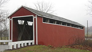
Stockheughter Covered Bridge, also known as Enochsburg Covered Bridge and County Bridge number 73, is a historic Howe Truss covered bridge located in Ray Township, Franklin County, Indiana. The bridge was built in 1891, and measures 101 feet, 10 inches, long, 13 feet high, and 13 feet wide. It has a gable roof and the exterior is clad in board and natten siding.: 5 It was listed on the National Register of Historic Places in 2002.
Weather in this IP's area
overcast clouds
5 Celsius
2 Celsius
5 Celsius
6 Celsius
1006 hPa
84 %
1006 hPa
971 hPa
10000 meters
5.81 m/s
11.62 m/s
240 degree
100 %