104.36.244.71 - IP Lookup: Free IP Address Lookup, Postal Code Lookup, IP Location Lookup, IP ASN, Public IP
Country:
 USA
USARegion:
City:
Location:
Time Zone:
Postal Code:
ISP:
ASN:
language:
User-Agent:
Proxy IP:
Blacklist:
IP information under different IP Channel
ip-api
Country
Region
City
ASN
Time Zone
ISP
Blacklist
Proxy
Latitude
Longitude
Postal
Route
db-ip
Country
Region
City
ASN
Time Zone
ISP
Blacklist
Proxy
Latitude
Longitude
Postal
Route
IPinfo
Country
Region
City
ASN
Time Zone
ISP
Blacklist
Proxy
Latitude
Longitude
Postal
Route
IP2Location
104.36.244.71Country
usRegion
washington
City
bellingham
Time Zone
America/Los_Angeles
ISP
Language
User-Agent
Latitude
Longitude
Postal
ipdata
Country
Region
City
ASN
Time Zone
ISP
Blacklist
Proxy
Latitude
Longitude
Postal
Route
Popular places and events near this IP address
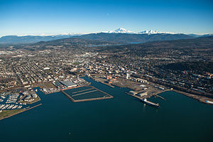
Bellingham, Washington
City in Washington, United States
Distance: Approx. 981 meters
Latitude and longitude: 48.75,-122.48333333
Bellingham ( BEL-ing-ham) is the county seat of Whatcom County in the U.S. state of Washington. It lies 21 miles (34 km) south of the U.S.–Canada border, between Vancouver, British Columbia, 52 miles (84 km) to the northwest and Seattle 90 miles (140 km) to the south. The population was 91,482 at the 2020 census, and estimated to be 94,720 in 2023.

SPARK Museum of Electrical Invention
Museum in Bellingham, Washington
Distance: Approx. 1242 meters
Latitude and longitude: 48.75145833,-122.48038611
The SPARK Museum of Electrical Invention (formerly the American Museum of Radio and Electricity) is an interactive museum located in Bellingham, Washington, United States, which offers educational experiences for audiences of all ages through galleries and public programs that illustrate the development and use of electricity, radio and the related inventions that changed the course of human history. The museum features a collection of artifacts showcasing four centuries of human innovation from 1580 into the 1950s.

T. G. Richards and Company Store
United States historic place
Distance: Approx. 1120 meters
Latitude and longitude: 48.75472222,-122.48611111
The T.G. Richards and Company Store, also known as Whatcom County Territorial Courthouse, is the first and oldest brick building in the state of Washington, United States, and is listed on the U.S. National Register of Historic Places.

Northwest Film School
Distance: Approx. 1230 meters
Latitude and longitude: 48.7475,-122.47916667
The Northwest Film School, in Bellingham, Washington, US, is a private, non-profit educational institution specializing in digital media production. The Northwest Film School operates in a partnership with Western Washington University to offer a one-year certificate in Video Production.

Flatiron Building (Bellingham, Washington)
United States historic place
Distance: Approx. 1232 meters
Latitude and longitude: 48.7517,-122.4807
The Hamilton Building also known as The Flatiron Building of Bellingham and the Bellingham Bay Furniture Building was the first "skyscraper" in Bellingham. Built in 1908 for Talifero Simpson Hamilton's growing Bellingham Bay (B.B.) Furniture Company established in 1889, the building cost $100,000 and used thirty-five thousand barrels of cement along with 200,000 pounds of steel. Due to its triangular shape and resemblance to the Fuller Building in New York, the building instantly garnered the flatiron nickname.

Aftermath Clubhouse
United States historic place
Distance: Approx. 1244 meters
Latitude and longitude: 48.7577,-122.491
The Aftermath Clubhouse is a two-story, wood-frame Italian Villa building which was originally constructed in 1904. It is estimated to be the first women's clubhouse in the state of Washington.

Whatcom Creek
River
Distance: Approx. 1062 meters
Latitude and longitude: 48.7530556,-122.4847222
Whatcom Creek (North Straits Salish: X̌’wótqwem /χˈʔwotqəm/) is a waterway in Bellingham, Washington, United States. Approximately 4 miles (6.4 km) long, it drains Lake Whatcom through Whatcom Falls Park and through the city of Bellingham to Bellingham Bay. The creek starts at the control dam for Lake Whatcom, in Whatcom Falls Park, where the creek goes over many falls, from about 350 feet (110 m) to about 80 feet above sea level.

Lottie Roth Block
United States historic place
Distance: Approx. 1198 meters
Latitude and longitude: 48.75611111,-122.48722222
The Lottie Roth Block is an historic commercial building located near downtown Bellingham, Washington and is listed on the U.S. National Register of Historic Places. Built by quarry manager and Washington State Legislator Charles Roth and named after his wife, Lottie, the building is clad in the famous Chuckanut Sandstone from his Bellingham Bay Quarry that would be used in countless building projects across the region. Completed in 1891, it was one of the last large commissions of noted Northwest architect Elmer H. Fisher and his only project in Whatcom County.

Safe Return (statue)
Bronze statue in Bellingham, Washington
Distance: Approx. 860 meters
Latitude and longitude: 48.754,-122.50086111
Safe Return is a memorial to deceased fishermen at Zuanich Point Park in Bellingham, Washington, United States. It is adjacent to the fishing port of Squalicum Harbor. Designed by Eugene Fairbanks, son of sculptor Avard Fairbanks, it features a bronze statue of a fisherman casting a mooring line, symbolizing a return home after fishing.

YWCA Building (Bellingham, Washington)
Local YWCA in a historic building
Distance: Approx. 1263 meters
Latitude and longitude: 48.74527778,-122.47888889
The YWCA Building is a historic Young Women's Christian Association building Bellingham, Washington that was completed in 1915.

Bellingham Herald Building
United States historic place
Distance: Approx. 1230 meters
Latitude and longitude: 48.7475,-122.47916667
The Bellingham Herald Building is a historical building located at 1155 N. State Street in downtown Bellingham, Washington. It was designed by Frederick Stanley Piper of Bellingham and Morrison & Stimsons of Seattle. It served as the headquarters of the Bellingham Herald newspaper since its completion in 1926 to 2019.
Barlow Building
United States historic place
Distance: Approx. 1155 meters
Latitude and longitude: 48.75055556,-122.48111111
The Barlow Building is a historical building located in downtown Bellingham, Washington. The building was completed in 1892. It is one of the oldest and best examples of a single-story commercial buildings still standing in Bellingham's business district.
Weather in this IP's area
overcast clouds
0 Celsius
-5 Celsius
-2 Celsius
1 Celsius
1019 hPa
69 %
1019 hPa
1007 hPa
10000 meters
4.63 m/s
30 degree
100 %