104.36.241.126 - IP Lookup: Free IP Address Lookup, Postal Code Lookup, IP Location Lookup, IP ASN, Public IP
Country:
 USA
USARegion:
City:
Location:
Time Zone:
Postal Code:
ISP:
ASN:
language:
User-Agent:
Proxy IP:
Blacklist:
IP information under different IP Channel
ip-api
Country
Region
City
ASN
Time Zone
ISP
Blacklist
Proxy
Latitude
Longitude
Postal
Route
db-ip
Country
Region
City
ASN
Time Zone
ISP
Blacklist
Proxy
Latitude
Longitude
Postal
Route
IPinfo
Country
Region
City
ASN
Time Zone
ISP
Blacklist
Proxy
Latitude
Longitude
Postal
Route
IP2Location
104.36.241.126Country
usRegion
washington
City
blaine
Time Zone
America/Los_Angeles
ISP
Language
User-Agent
Latitude
Longitude
Postal
ipdata
Country
Region
City
ASN
Time Zone
ISP
Blacklist
Proxy
Latitude
Longitude
Postal
Route
Popular places and events near this IP address

Birch Bay, Washington
CDP in Washington, United States
Distance: Approx. 2982 meters
Latitude and longitude: 48.93222222,-122.74722222
Birch Bay (Tsan-wuch, Say-wak) is a protected bay of the east shore of the Salish Sea, between Semiahmoo Bay and Lummi Bay; approximately 100 miles (160 km) north of Seattle and 35 miles (56 km) south of Vancouver, BC, Canada. The bay gives its name to a census-designated place (CDP) along the bay's shore in Whatcom County, Washington, United States. The population was 8,413 at the 2010 census, a 69.6% increase over the 4,961 individuals in the 2000 census.

Blaine, Washington
Border city in Washington, United States
Distance: Approx. 3289 meters
Latitude and longitude: 48.98805556,-122.74361111
Blaine is a city in Whatcom County, Washington, United States. The city's northern boundary is the Canada–U.S. border; the Peace Arch international monument straddles the border of both countries. It is the fourth largest incorporated city within the Bellingham Metropolitan Area.
Peace Arch Border Crossing
Border crossing between Canada and the United States
Distance: Approx. 4737 meters
Latitude and longitude: 49.00011111,-122.75438889
The Peace Arch Border Crossing is the common name for the Blaine–Douglas crossing which connects the cities of Blaine, Washington and Surrey, British Columbia on the Canada–United States border. I-5 on the American side joins BC Highway 99 on the Canadian side. Being the most direct route between the major cities of Seattle, Washington and Vancouver, British Columbia, the crossing is the third-busiest on the border with up to 4,800 cars a day.

Semiahmoo Harbor Light
Lighthouse
Distance: Approx. 4929 meters
Latitude and longitude: 48.99219,-122.78406
The Semiahmoo Harbor Lighthouse was a lighthouse on Semiahmoo ( SEM-ee-AH-moh) Bay near the port of Blaine, Whatcom County, Washington, in the United States.

Blaine High School (Washington)
Public school
Distance: Approx. 3794 meters
Latitude and longitude: 48.992658,-122.738176
Blaine High School, established in 1906, is located in Blaine, Washington, United States, which is situated in the northwest corner of the state, adjacent to the Canada–US border. The school operates within the Blaine School District and serves approximately 639 students in grades 9-12. It is ranked 39th out of 539 high schools in the state.
Douglas, Surrey
Neighbourhood in British Columbia, Canada
Distance: Approx. 4929 meters
Latitude and longitude: 49.00277778,-122.73555556
Douglas, formerly known as "Doug," is a locality in Surrey, British Columbia, Canada. Just southeast and outside of the boundary of White Rock, it is on the Canadian side of the Peace Arch Border Crossing between British Columbia and Whatcom County, Washington, in the United States. Douglas is the location of the Peace Arch Provincial Park portion of the International Peace Arch Park, which it shares with Peace Arch State Park in Blaine, Washington.

Semiahmoo Spit
Spit in Whatcom County, Washington state
Distance: Approx. 4191 meters
Latitude and longitude: 48.98333333,-122.78333333
Semiahmoo Spit is a spit that protrudes from the westernmost expanse of shore on Semiahmoo Peninsula between Semiahmoo Bay and Drayton Harbor off the coast of Blaine in Whatcom County, Washington state. The spit is home to Semiahmoo Park.
KVRI
Radio station in Blaine, Washington, serving Vancouver, British Columbia
Distance: Approx. 547 meters
Latitude and longitude: 48.95416667,-122.74333333
KVRI (1600 AM) (branded as Radio Punjab) is a commercial radio station licensed to Blaine, Washington, United States, and serving Greater Vancouver in British Columbia, Canada. It airs a radio format of Bollywood music, news and talk in Hindi, Punjabi and other South Asian languages. It is owned by Multicultural Broadcasting.
Blaine Municipal Airport
Defunct airport in Washington, United States
Distance: Approx. 3539 meters
Latitude and longitude: 48.99,-122.7325
Blaine Municipal Airport (IATA: BWS, FAA LID: 4W6) was a city-owned public-use airport, also known as Dierks Field, located one nautical mile (1.8 km) east of the central business district of Blaine, a city in Whatcom County, Washington, United States. It was closed on December 31, 2008.

Semiahmoo Resort
Resort and spa near Blaine, Washington
Distance: Approx. 4192 meters
Latitude and longitude: 48.98916667,-122.77361111
Semiahmoo Resort is a golfing resort and spa overlooking Semiahmoo Bay, opposite Blaine, Washington, northwest of Bellingham in the northwestern coast of the United States. Set within 1,100 acres (450 ha), it lies on a long sandy spit in the northern part of Puget Sound near the Canada–US border. The name of the resort is from the Semiahmoo indigenous people in whose Salish language it is the word for "half moon" and describes the crescent shaped land the resort was built on.

MV Plover
United States historic place
Distance: Approx. 4155 meters
Latitude and longitude: 48.99388889,-122.75861111
MV Plover is an 11-ton, 17-passenger ferry in Whatcom County, Washington, built in 1944, listed on the National Register of Historic Places in 1997. She is owned by the City of Blaine, Washington and operated by the nonprofit Drayton Harbor Maritime. She originally ferried workers from Blaine to the Alaska Packers' Association cannery at Semiahmoo Spit (now the site of Semiahmoo Resort), carrying out this function until 1964.

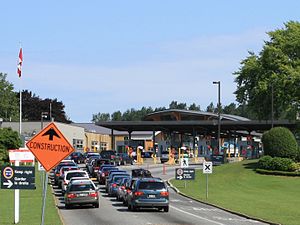
Pacific Highway Border Crossing
Border crossing between Canada and the United States
Distance: Approx. 4846 meters
Latitude and longitude: 49.002,-122.735
The Pacific Highway Border Crossing connects the city of Blaine, Washington and the city of Surrey, British Columbia on the Canada–US border. Interstate 5/Washington State Route 543 on the American side joins British Columbia Highway 15 on the Canadian side. Since the 1970s, commercial vehicles driving directly between Blaine and Surrey have been required to use this route, one of the five busiest commercial US-Canada border crossings.
Weather in this IP's area
clear sky
-1 Celsius
-1 Celsius
-2 Celsius
1 Celsius
1027 hPa
47 %
1027 hPa
1022 hPa
10000 meters
0.89 m/s
1.79 m/s
307 degree