Country:
 USA
USARegion:
City:
Latitude and Longitude:
Time Zone:
Postal Code:
IP information under different IP Channel
ip-api
Country
Region
City
ASN
Time Zone
ISP
Blacklist
Proxy
Latitude
Longitude
Postal
Route
IPinfo
Country
Region
City
ASN
Time Zone
ISP
Blacklist
Proxy
Latitude
Longitude
Postal
Route
MaxMind
Country
Region
City
ASN
Time Zone
ISP
Blacklist
Proxy
Latitude
Longitude
Postal
Route
Luminati
Country
USRegion
md
City
princessanne
ASN
Time Zone
America/New_York
ISP
COGENT-174
Latitude
Longitude
Postal
db-ip
Country
Region
City
ASN
Time Zone
ISP
Blacklist
Proxy
Latitude
Longitude
Postal
Route
ipdata
Country
Region
City
ASN
Time Zone
ISP
Blacklist
Proxy
Latitude
Longitude
Postal
Route
Popular places and events near this IP address

Hughesville, Maryland
Census-designated place in Maryland, United States
Distance: Approx. 1304 meters
Latitude and longitude: 38.53361111,-76.78222222
Hughesville is a census-designated place (CDP) in Charles County, Maryland, United States. The population was 2,197 at the 2010 census. Truman's Place was listed on the National Register of Historic Places in 1988.

Charlotte Hall, Maryland
CDP in Maryland, United States
Distance: Approx. 7188 meters
Latitude and longitude: 38.47722222,-76.77638889
Charlotte Hall is a census-designated place (CDP) in Charles and St. Mary's counties, Maryland, United States. The population was 1,420 at the 2010 census.
Charlotte Hall Historic District
Historic district in Maryland, United States
Distance: Approx. 7158 meters
Latitude and longitude: 38.4775,-76.77638889
Charlotte Hall Historic District is a national historic district in Charlotte Hall, St. Mary's County, Maryland. It encompasses a small village along "Old Route 5." It includes 13 recorded buildings and sites of historic and/or architectural interest as well as the main campus of the Charlotte Hall Military Academy.
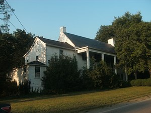
Oakland (Bryantown, Maryland)
Historic house in Maryland, United States
Distance: Approx. 2478 meters
Latitude and longitude: 38.55833333,-76.81111111
Oakland is a historic home located near Bryantown, Charles County, Maryland, United States. It is a two-story, three-bay brick dwelling constructed in the Federal style between 1822 and 1823. About 1880, the Greek Revival entrance and the Italianate front porch were constructed.
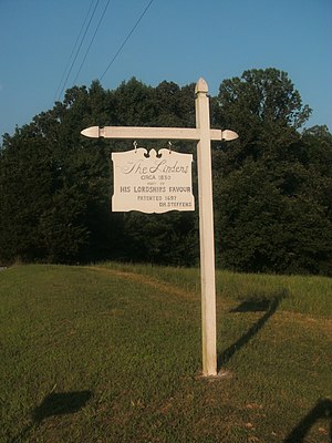
The Lindens (Bryantown, Maryland)
Historic house in Maryland, United States
Distance: Approx. 7169 meters
Latitude and longitude: 38.55194444,-76.87555556
The Lindens is a historic home located near Bryantown, Charles County, Maryland. It is a two-story frame house built during the second quarter of the 19th century in the Federal style. It is in the double parlor plan with Greek Revival mantels and an exterior double chimney.
Truman's Place
Historic house in Maryland, United States
Distance: Approx. 3224 meters
Latitude and longitude: 38.56611111,-76.77805556
Truman's Place is a historic home located at Hughesville, Charles County, Maryland, United States. It is a 2+1⁄2-story brick structure with a smaller two-story brick wing built in the mid-19th century. The house incorporates the brick shell of a 1770, one-story, five-bay dwelling with a kitchen-service wing.
Bryantown Historic District
Historic district in Maryland, United States
Distance: Approx. 4547 meters
Latitude and longitude: 38.55305556,-76.84416667
Bryantown Historic District is a national historic district in Bryantown, Charles County, Maryland. It consists of 19 contributing buildings, structures, and sites and five non-contributing buildings and structures. The nucleus of the district is a group of four 19th century buildings flanking Old Route 5 west of the former crossroads.

Bryantown, Maryland
Census-designated place in Maryland, United States
Distance: Approx. 4439 meters
Latitude and longitude: 38.555,-76.84194444
Bryantown is an unincorporated community and census-designated place in Charles County, Maryland, United States, adjacent to Maryland Route 5. As of the 2010 census, it had a population of 655. Bryantown stands on land known as Boarman's Manor, a 4,000-acre (16 km2) manor granted to Major William Boarman in 1674.
Patuxent, Maryland
Unincorporated community in Maryland, United States
Distance: Approx. 4006 meters
Latitude and longitude: 38.53916667,-76.74861111
Patuxent is an unincorporated community in Charles County, Maryland, United States. Maxwell Hall was listed on the National Register of Historic Places in 1974.
Masons, Maryland
Unincorporated community in Maryland, United States
Distance: Approx. 2168 meters
Latitude and longitude: 38.55916667,-76.80027778
Masons is an unincorporated community in Charles County, Maryland, United States.
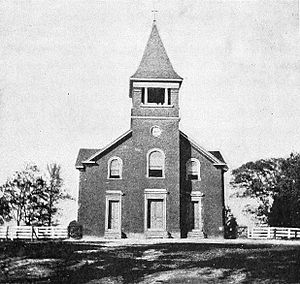
St. Mary's Catholic Church (Bryantown, Maryland)
Church in Maryland, United States
Distance: Approx. 3688 meters
Latitude and longitude: 38.53944444,-76.83694444
St. Mary's Catholic Church is a parish of the Roman Catholic Church located near Bryantown, Maryland, in the Roman Catholic Archdiocese of Washington. Established in 1793, it operates a parochial school and houses a large cemetery.
Three Notch Trail
Rail trail in St. Mary's County, MD
Distance: Approx. 3553 meters
Latitude and longitude: 38.512176,-76.775067
The Three Notch Trail is a 10.6-mile (17.1 km) (26 mile planned), shared-use rail trail in the US state of Maryland. It currently runs on the right-of-way of the old U.S. Naval Air Station Railroad from Deborah Drive in Hughesville, MD just inside Charles County to Baggett Park in Mechanicsville, MD with several short, disconnected sections in the California, MD area. It is almost entirely within St.
Weather in this IP's area
clear sky
13 Celsius
13 Celsius
11 Celsius
16 Celsius
1016 hPa
89 %
1016 hPa
1010 hPa
10000 meters
3.35 m/s
10.15 m/s
328 degree
06:43:09
19:26:35