Country:
 USA
USARegion:
City:
Latitude and Longitude:
Time Zone:
Postal Code:
IP information under different IP Channel
ip-api
Country
Region
City
ASN
Time Zone
ISP
Blacklist
Proxy
Latitude
Longitude
Postal
Route
IPinfo
Country
Region
City
ASN
Time Zone
ISP
Blacklist
Proxy
Latitude
Longitude
Postal
Route
MaxMind
Country
Region
City
ASN
Time Zone
ISP
Blacklist
Proxy
Latitude
Longitude
Postal
Route
Luminati
Country
USASN
Time Zone
America/Chicago
ISP
FRONTIER-FRTR
Latitude
Longitude
Postal
db-ip
Country
Region
City
ASN
Time Zone
ISP
Blacklist
Proxy
Latitude
Longitude
Postal
Route
ipdata
Country
Region
City
ASN
Time Zone
ISP
Blacklist
Proxy
Latitude
Longitude
Postal
Route
Popular places and events near this IP address

Sheridan, Wyoming
City in Wyoming, United States
Distance: Approx. 332 meters
Latitude and longitude: 44.79666667,-106.95888889
Sheridan is a city in the U.S. state of Wyoming and the county seat of Sheridan County. The city is located halfway between Yellowstone Park and Mount Rushmore by U.S. Route 14 and 16. It is the principal town of the Sheridan, Wyoming, Micropolitan Statistical Area which encompasses all of Sheridan County.
Little Goose Creek
Distance: Approx. 633 meters
Latitude and longitude: 44.80305556,-106.95805556
Little Goose Creek is a creek originating on the east slope of the Big Horn Mountains in north-central Wyoming.
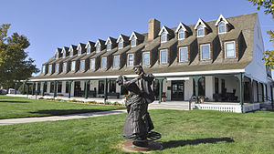
Sheridan Inn
United States historic place
Distance: Approx. 960 meters
Latitude and longitude: 44.80638889,-106.95388889
The Sheridan Inn is a historic hotel in Sheridan, Wyoming. Designed by the architect Thomas R. Kimball of Omaha, Nebraska in 1893, it was constructed by the Chicago, Burlington, and Quincy Railroad as part of its development program in Wyoming associated with extension of the railway. Equipped with the first bathtubs and electric lights in that part of Wyoming, the inn was considered the "finest hotel" between Chicago and San Francisco.

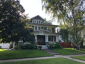
Mount View (Sheridan, Wyoming)
Historic house in Wyoming, United States
Distance: Approx. 836 meters
Latitude and longitude: 44.79166667,-106.96111111
Mount View is a historic house located at 610 S. Jefferson St. in Sheridan, Wyoming. The Prairie School home was built from 1911 to 1912 and designed by Glenn Charles McAllister.

Sheridan County Courthouse (Wyoming)
United States historic place
Distance: Approx. 319 meters
Latitude and longitude: 44.795,-106.95583333
The Sheridan County Courthouse, located at the intersection of Burkett and Main Streets in Sheridan, is the seat of government of Sheridan County, Wyoming. Built from 1904 to 1905, the courthouse was the first built in the county. The firm of Link & McAllister designed the courthouse; their design features elements of the Classical Revival and Beaux-Arts styles.

Trail End
Historic house in Wyoming, United States
Distance: Approx. 964 meters
Latitude and longitude: 44.80138889,-106.96611111
Trail End, also known as the John B. Kendrick Mansion, is a historic home located at 400 Clarendon Avenue in Sheridan, Wyoming. The home was built and inhabited by Wyoming governor and U.S. Senator John B. Kendrick. Built from 1908 to 1913, the house was designed by Glenn Charles MacAlister and cost $164,000.
KHNA-LP
Radio station in Sheridan, Wyoming
Distance: Approx. 218 meters
Latitude and longitude: 44.79763889,-106.95225
KHNA-LP (94.3 FM) is a low-power FM radio station broadcasting a Catholic Radio format. Licensed to Sheridan, Wyoming, US, the station is currently owned by Aperio Radio, Inc. The transmitter for the station is located in downtown Sheridan atop an office building.

St. Peter's Episcopal Church (Sheridan, Wyoming)
United States historic place
Distance: Approx. 254 meters
Latitude and longitude: 44.79708333,-106.95805556
St Peter's Episcopal Church is a brick Gothic Revival style church built in 1912 in Sheridan, Wyoming. It was listed on the National Register of Historic Places in 2013. It was designed by architect Edward E. Hendrickson of Frank Miles Day firm in Philadelphia.

Sheridan Railroad Historic District
Historic district in Wyoming, United States
Distance: Approx. 846 meters
Latitude and longitude: 44.80527778,-106.95305556
The Sheridan Railroad Historic District, in Sheridan, Wyoming, is a 37 acres (15 ha) historic district which was listed on the National Register of Historic Places in 2004. The district includes railroad-related resources and a well-preserved working-class neighborhood. The district includes 110 contributing buildings and two contributing structures in an area including 201-841 Broadway and 508-955 N. Gould.

Sheridan Main Street Historic District
Historic district in Wyoming, United States
Distance: Approx. 93 meters
Latitude and longitude: 44.79861111,-106.95527778
The Sheridan Main Street Historic District, in Sheridan, Wyoming, is a 16.4 acres (6.6 ha) historic district which was listed on the National Register of Historic Places in 1982. It includes both sides of several blocks of Main Street, from Burkitt Street to Mandel Street, an area including the oldest portion of the historic core of Sheridan, dating back to 1882. It included 57 contributing buildings.
Robinson-Smith House
United States historic place
Distance: Approx. 652 meters
Latitude and longitude: 44.79222222,-106.9575
The Robinson-Smith House was built in 1909. It was listed on the National Register of Historic Places in 2016. It is American Foursquare in style.

Holy Name Catholic School
United States historic place
Distance: Approx. 379 meters
Latitude and longitude: 44.79555556,-106.95138889
The Holy Name Catholic School is a school and a historic school building located at 121 S. Connor Street in Sheridan, Wyoming. The school is one of the oldest Catholic schools in Wyoming, and its 1914 building is the oldest Catholic school building in the state. The original brick school building and a secondary annex building constructed in 1952 were listed on the National Register of Historic Places in 2013.
Weather in this IP's area
clear sky
19 Celsius
18 Celsius
16 Celsius
20 Celsius
1009 hPa
42 %
1009 hPa
884 hPa
10000 meters
06:52:00
19:10:54