Country:
Region:
City:
Latitude and Longitude:
Time Zone:
Postal Code:
IP information under different IP Channel
ip-api
Country
Region
City
ASN
Time Zone
ISP
Blacklist
Proxy
Latitude
Longitude
Postal
Route
Luminati
Country
Region
pa
City
northmiddletontownship
ASN
Time Zone
America/New_York
ISP
SHENTEL
Latitude
Longitude
Postal
IPinfo
Country
Region
City
ASN
Time Zone
ISP
Blacklist
Proxy
Latitude
Longitude
Postal
Route
db-ip
Country
Region
City
ASN
Time Zone
ISP
Blacklist
Proxy
Latitude
Longitude
Postal
Route
ipdata
Country
Region
City
ASN
Time Zone
ISP
Blacklist
Proxy
Latitude
Longitude
Postal
Route
Popular places and events near this IP address

Carlisle, Pennsylvania
Borough in Pennsylvania, United States
Distance: Approx. 5195 meters
Latitude and longitude: 40.2025,-77.195
Carlisle is a borough in and the county seat of Cumberland County, Pennsylvania, United States. Carlisle is located within the Cumberland Valley, a highly productive agricultural region. As of the 2020 census, the borough population was 20,118; including suburbs in the neighboring townships, 37,695 live in the Carlisle urban cluster.
Lower Frankford Township, Pennsylvania
Township in Pennsylvania, United States
Distance: Approx. 4447 meters
Latitude and longitude: 40.23333333,-77.26638889
Lower Frankford Township is a township in Cumberland County, Pennsylvania, United States. The population was 1,732 at the 2010 census.

North Middleton Township, Pennsylvania
Township in Pennsylvania, United States
Distance: Approx. 1982 meters
Latitude and longitude: 40.23333333,-77.23305556
North Middleton Township is a township in Cumberland County, Pennsylvania, United States. The population was 12,039 at the 2020 census.
Schlusser, Pennsylvania
Census-designated place in Pennsylvania, United States
Distance: Approx. 2941 meters
Latitude and longitude: 40.23861111,-77.18361111
Schlusser (pronounced Skloosher) is a census-designated place (CDP) in North Middleton and Middlesex townships, Cumberland County, Pennsylvania, United States. The population was 5,265 at the 2010 census. It is part of the Harrisburg–Carlisle Metropolitan Statistical Area.
Dickinson College
Private college in Carlisle, Pennsylvania, U.S.
Distance: Approx. 5176 meters
Latitude and longitude: 40.20262,-77.19522
Dickinson College is a private liberal arts college in Carlisle, Pennsylvania, United States. Founded in 1773 as Carlisle Grammar School, Dickinson was chartered on September 9, 1783, making it the first college to be founded after the formation of the United States. Dickinson was founded by Benjamin Rush, a Founding Father and signer of the Declaration of Independence.
Carlisle High School (Carlisle, Pennsylvania)
School in Carlisle, Pennsylvania, United States
Distance: Approx. 3984 meters
Latitude and longitude: 40.21111111,-77.20694444
Carlisle High School is a public high school located in Carlisle, Pennsylvania, United States. It serves grades 9–12 for the Carlisle Area School District. The district includes Carlisle and Mount Holly Springs boroughs (the latter being an exclave of the school district), and the townships of and Dickinson and North Middleton.

Strategic Studies Institute
U.S. Army research institute
Distance: Approx. 5268 meters
Latitude and longitude: 40.210936,-77.175311
The Strategic Studies Institute (SSI) is the U.S. Army's institute for strategic and national security research and analysis. It is part of the U.S. Army War College. SSI conducts strategic research and analysis to support the U.S. Army War College curricula, provides direct analysis for Army and Department of Defense leadership, and serves as a bridge to the wider strategic community.

Old West, Dickinson College
United States historic place
Distance: Approx. 5137 meters
Latitude and longitude: 40.203,-77.1952
Old West was the first building to be erected on the campus of Dickinson College in Carlisle, Pennsylvania. It was designed by Benjamin Henry Latrobe in 1803, completed in 1822, and is a fine example of Federal period architecture. It was designated as a National Historic Landmark in 1962 for its architecture and its association with Latrobe.
Caprivi, Pennsylvania
Unincorporated community in Pennsylvania, United States
Distance: Approx. 1285 meters
Latitude and longitude: 40.2434,-77.2315
Caprivi is an unincorporated community located in North Middleton Township, Cumberland County, Pennsylvania, United States. Situated on Pennsylvania Route 74 north of Carlisle, the community is an agricultural enclave.

Carlisle Area School District
School district in Pennsylvania
Distance: Approx. 4106 meters
Latitude and longitude: 40.20994,-77.20727
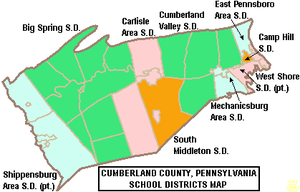
The Carlisle Area School District is a midsized, suburban, public school district that serves the boroughs of Carlisle and Mount Holly Springs and Dickinson Township and North Middleton Township in Cumberland County, Pennsylvania. Carlisle Area School District encompasses approximately 75 square miles (190 km2). According to 2000 federal census data, it serves a resident population of 34,794.
Carlisle Fairgrounds
Distance: Approx. 4262 meters
Latitude and longitude: 40.216369,-77.185208
Carlisle Fairgrounds is located in downtown Carlisle, Pennsylvania. It is the home of Carlisle Events and the location for the largest collector car and truck events in the country. Prior to Carlisle Events' emergence, anyone interested in restoring or showing 1950s- or 1960s-era cars had few options.

Carlisle Armory (Carlisle, Pennsylvania)
United States historic place
Distance: Approx. 4335 meters
Latitude and longitude: 40.22027778,-77.17861111
Carlisle Armory is a historic National Guard armory located at Carlisle, Cumberland County, Pennsylvania. It was built in 1931, and consists of separate administration and stable buildings executed in the Colonial Revival style. It was designed by architect Thomas H. Atherton.
Weather in this IP's area
overcast clouds
6 Celsius
6 Celsius
5 Celsius
7 Celsius
1024 hPa
58 %
1024 hPa
1005 hPa
10000 meters
0.45 m/s
1.34 m/s
58 degree
100 %
06:54:06
16:52:53
