104.247.149.106 - IP Lookup: Free IP Address Lookup, Postal Code Lookup, IP Location Lookup, IP ASN, Public IP
Country:
Region:
City:
Location:
Time Zone:
Postal Code:
ISP:
ASN:
language:
User-Agent:
Proxy IP:
Blacklist:
IP information under different IP Channel
ip-api
Country
Region
City
ASN
Time Zone
ISP
Blacklist
Proxy
Latitude
Longitude
Postal
Route
db-ip
Country
Region
City
ASN
Time Zone
ISP
Blacklist
Proxy
Latitude
Longitude
Postal
Route
IPinfo
Country
Region
City
ASN
Time Zone
ISP
Blacklist
Proxy
Latitude
Longitude
Postal
Route
IP2Location
104.247.149.106Country
Region
california
City
fresno
Time Zone
America/Los_Angeles
ISP
Language
User-Agent
Latitude
Longitude
Postal
ipdata
Country
Region
City
ASN
Time Zone
ISP
Blacklist
Proxy
Latitude
Longitude
Postal
Route
Popular places and events near this IP address
Institute of Technology (California/Oregon)
Distance: Approx. 4063 meters
Latitude and longitude: 36.8375,-119.80305556
The Institute of Technology (IOT) is a vocational school operating in California and Oregon. Several career training programs are offered at its four campus locations at Clovis, Modesto, Redding, and Salem, Oregon.

Forestiere Underground Gardens
United States historic place
Distance: Approx. 3646 meters
Latitude and longitude: 36.80722222,-119.88083333
The Forestiere Underground Gardens in Fresno, California are a series of subterranean structures built by Baldassare Forestiere, an immigrant from Sicily, over a period of 40 years from 1906 to his death in 1946. The gardens are operated by members of the Forestiere family through the Forestiere Historical Center, and can be considered an unconventional example of vernacular architecture.

River Park (Fresno, California)
Shopping mall in California, United States
Distance: Approx. 5703 meters
Latitude and longitude: 36.84723,-119.78877
River Park is an outdoor shopping center in Fresno, California on the east side of Blackstone Avenue.
Fresno California Temple
Distance: Approx. 1173 meters
Latitude and longitude: 36.82819444,-119.85297222
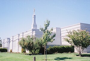
The Fresno California Temple is the 78th operating temple of the Church of Jesus Christ of Latter-day Saints (LDS Church).

Pinedale, California
Place in California, United States
Distance: Approx. 5366 meters
Latitude and longitude: 36.84277778,-119.79
Pinedale is a previously unincorporated community in Fresno County, California. It lies at an elevation of 348 feet (106 m). It was once a rural community located on the Southern Pacific Railroad 3.5 miles (5.6 km) north-northwest of Clovis but has since become surrounded and annexed by the city of Fresno.

Bullard High School (Fresno, California)
Public school in the United States
Distance: Approx. 3021 meters
Latitude and longitude: 36.81722222,-119.81
Bullard High School is a public secondary school located in Fresno, California, United States. Founded in 1955 and recognized as one of Fresno's top public schools, it is part of the Fresno Unified School District, and as of 2011 had around 2,650 students on roll in grades 9–12, approximately 650 students per grade.

Sierra Sky Park Airport
Airport
Distance: Approx. 3163 meters
Latitude and longitude: 36.84027778,-119.86944444
Sierra Sky Park Airport (FAA LID: E79, formerly Q60) is a privately owned, public-use airport seven miles (11 km) northwest of the central business district of Fresno, a city in Fresno County, California, United States. Other area airports are Fresno Chandler Executive Airport and Fresno Yosemite International Airport.
Temple Beth Israel (Fresno, California)
Reform Jewish synagogue in California, US
Distance: Approx. 4232 meters
Latitude and longitude: 36.834457,-119.799272
Temple Beth Israel (Hebrew: בית ישראל) is a Reform Jewish congregation and synagogue located at 6622 North Maroa Avenue in Fresno, California, in the United States. Founded in 1919, it was the first and remains the oldest synagogue in the San Joaquin Valley. As of 2011, the rabbi was Rick Winer.

Old Fig Garden, California
Census-designated place in California, United States
Distance: Approx. 4293 meters
Latitude and longitude: 36.79833333,-119.80444444
Old Fig Garden (formerly, Fig Garden) is a census-designated place in Fresno County, California. It lies at an elevation of 312 feet (95 m). The city of Fresno, through annexations, has entirely circled Fig Garden.
Figarden, California
Unincorporated community in California, United States
Distance: Approx. 1699 meters
Latitude and longitude: 36.82277778,-119.8625
Figarden (formerly, Bullard and Fig Garden) was an unincorporated community in Fresno County, California. It is located 6 miles (9.7 km) northwest of downtown Fresno, at an elevation of 315 feet (96 m). A post office operated at Figarden from 1925 to 1944, moving in 1939, and from 1947 to 1951.
Highway City, California
Unincorporated community in California, United States
Distance: Approx. 3853 meters
Latitude and longitude: 36.81083333,-119.885
Highway City is an unincorporated community in Fresno County, California. It is located 2.5 miles (4 km) southeast of Herndon, at an elevation of 299 feet (91 m). A post office opened in Highway City in 1951.
Sierra Sky Park, California
Unincorporated community in California, United States
Distance: Approx. 3100 meters
Latitude and longitude: 36.84222222,-119.86583333
Sierra Sky Park is a fly-in unincorporated community in Fresno County, California. It is located 7 miles (11 km) northwest of downtown Fresno, at an elevation of 328 feet (100 m).
Weather in this IP's area
clear sky
11 Celsius
9 Celsius
11 Celsius
11 Celsius
1024 hPa
51 %
1024 hPa
1013 hPa
10000 meters
0.82 m/s
0.84 m/s
180 degree
4 %
