Country:
 USA
USARegion:
City:
Latitude and Longitude:
Time Zone:
Postal Code:
IP information under different IP Channel
ip-api
Country
Region
City
ASN
Time Zone
ISP
Blacklist
Proxy
Latitude
Longitude
Postal
Route
IPinfo
Country
Region
City
ASN
Time Zone
ISP
Blacklist
Proxy
Latitude
Longitude
Postal
Route
MaxMind
Country
Region
City
ASN
Time Zone
ISP
Blacklist
Proxy
Latitude
Longitude
Postal
Route
Luminati
Country
USRegion
tx
City
fortworth
ASN
Time Zone
America/Chicago
ISP
DATABANK-DFW
Latitude
Longitude
Postal
db-ip
Country
Region
City
ASN
Time Zone
ISP
Blacklist
Proxy
Latitude
Longitude
Postal
Route
ipdata
Country
Region
City
ASN
Time Zone
ISP
Blacklist
Proxy
Latitude
Longitude
Postal
Route
Popular places and events near this IP address

Edgecliff Village, Texas
Town in Texas, United States
Distance: Approx. 2931 meters
Latitude and longitude: 32.65611111,-97.34305556
Edgecliff Village is a town in Tarrant County, Texas, United States. It is an enclave suburb of, and surrounded by the city of Fort Worth. The population was 2,049 at the 2020 census.

Wedgwood Baptist Church shooting
Mass shooting in Fort Worth, Texas, United States
Distance: Approx. 1525 meters
Latitude and longitude: 32.6643,-97.3845
On September 15, 1999, a mass shooting occurred at Wedgwood Baptist Church in Fort Worth, Texas. 47-year-old Larry Gene Ashbrook entered during a See You at the Pole Rally featuring a concert by the Christian rock group Forty Days, where he killed seven people and wounded seven others before committing suicide. Most of the victims were teenagers.

Southwestern Baptist Theological Seminary
Seminary in Fort Worth, Texas, U.S.
Distance: Approx. 3994 meters
Latitude and longitude: 32.682,-97.348
The Southwestern Baptist Theological Seminary is a Baptist theological institute in Fort Worth, Texas. It is affiliated with the Southern Baptist Convention. It was established in 1908 and in 2005 was one of the largest seminaries in the world.
Wedgwood, Fort Worth, Texas
Neighborhood in Fort Worth, Texas
Distance: Approx. 2716 meters
Latitude and longitude: 32.651,-97.403
Wedgwood is a neighborhood in Fort Worth, Texas (USA), located on the southwest part of the city. It is bounded by Granbury Rd on the northwest, Altamesa Blvd on the south, McCart Ave & Westcreek Dr on the east, and Interstate 20 on the north. Most of the streets in Wedgwood begin with a "W", such as Wedgmont, Wrigley and Winifred.
Trinity Valley School
Private school in Fort Worth, Texas, United States
Distance: Approx. 4921 meters
Latitude and longitude: 32.653829,-97.426704
Trinity Valley School ("TVS") is a PK-12, co-ed, independent school in Fort Worth, Texas. Trinity Valley School has four main objectives for its students: fine scholarship with its fulfillment at college; the development of wide constructive interests; intelligent citizenship; and spiritual and moral development which promotes lasting values. Trinity Valley School is a member of the Southwest Preparatory Conference and is accredited by the Independent Schools Association of the Southwest (ISAS).
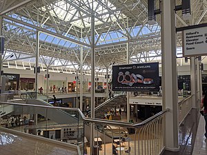
Hulen Mall
Shopping mall in Texas, United States
Distance: Approx. 3564 meters
Latitude and longitude: 32.6784,-97.3984
Hulen Mall is a diverse-scale shopping mall located in southwest Fort Worth, Texas, United States. Located at the southwest corner of Interstate 20 and Hulen Street, it is in the southwest side of the DFW Metroplex. The mall is anchored by two major department stores and contains 118 specialty shops and stores.
Sycamore Strip Airport
Airport in Fort Worth, Texas
Distance: Approx. 3420 meters
Latitude and longitude: 32.62833333,-97.35361111
Sycamore Strip Airport (FAA LID: 9F9) is a public airport located eight miles (12.9 km) southwest of the central business district (CBD) of Fort Worth, in Tarrant County, Texas, United States. It is owned by a local flight school, A & W Aircraft. The airport, which has a paved runway, is used solely for general aviation purposes including aircraft rental and flight school.
Southwest High School (Fort Worth, Texas)
Public school in the United States
Distance: Approx. 694 meters
Latitude and longitude: 32.65207,-97.38135
Southwest High School is a public high school in Fort Worth, Texas, United States. It is one of fourteen traditional high schools in the Fort Worth Independent School District. The school has an enrollment of about 1,288 with a teaching staff of about 85.

Fort Worth Academy of Fine Arts
Public arts, charter school in the United States
Distance: Approx. 4514 meters
Latitude and longitude: 32.69111111,-97.39277778
The Fort Worth Academy of Fine Arts (FWAFA) is a fine arts public arts charter school in Fort Worth, Texas, founded in 2001 by the Texas Boys Choir, Inc. The school serves grades 3 through 12 and emphasizes the arts. Its programs include dance, choral music, theater, and visual arts.
Texas Baptist College
Distance: Approx. 3875 meters
Latitude and longitude: 32.6820686,-97.3502345
Texas Baptist College is a Baptist college in Fort Worth, Texas, United States. It is affiliated with the Southwestern Baptist Theological Seminary (Southern Baptist Convention).
South Hills High School (Texas)
Public secondary school in Fort Worth, Texas, United States
Distance: Approx. 1496 meters
Latitude and longitude: 32.6575,-97.35888889
South Hills High School is a 9-12 public high school in Fort Worth, Texas, United States. It is one of 14 zoned high schools in the Fort Worth Independent School District.
Cristo Rey Fort Worth College Prep
Private, work-study, prep school in Fort Worth, Texas, United States
Distance: Approx. 1738 meters
Latitude and longitude: 32.6482,-97.35684
Cristo Rey Fort Worth College Prep is a Roman Catholic high school in Fort Worth, Texas. It is a part of the Cristo Rey Network of 38 schools throughout the United States and is under the Roman Catholic Diocese of Fort Worth. The first Cristo Rey School was established in 1996 in Chicago, Illinois.
Weather in this IP's area
scattered clouds
32 Celsius
36 Celsius
31 Celsius
34 Celsius
1011 hPa
53 %
1011 hPa
985 hPa
10000 meters
2.57 m/s
310 degree
40 %
07:14:13
19:34:17