104.244.191.206 - IP Lookup: Free IP Address Lookup, Postal Code Lookup, IP Location Lookup, IP ASN, Public IP
Country:
 Canada
Region:
City:
Location:
Time Zone:
Postal Code:
ISP:
ASN:
language:
User-Agent:
Proxy IP:
Blacklist:
IP information under different IP Channel
ip-api
Country
Region
City
ASN
Time Zone
ISP
Blacklist
Proxy
Latitude
Longitude
Postal
Route
db-ip
Country
Region
City
ASN
Time Zone
ISP
Blacklist
Proxy
Latitude
Longitude
Postal
Route
IPinfo
Country
Region
City
ASN
Time Zone
ISP
Blacklist
Proxy
Latitude
Longitude
Postal
Route
IP2Location
104.244.191.206Country
caRegion
british columbia
City
burnaby
Time Zone
America/Vancouver
ISP
Language
User-Agent
Latitude
Longitude
Postal
ipdata
Country
Region
City
ASN
Time Zone
ISP
Blacklist
Proxy
Latitude
Longitude
Postal
Route
Popular places and events near this IP address
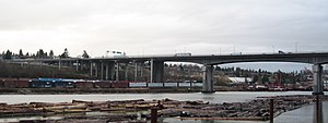
Queensborough Bridge
Bridge in New Westminster, British Columbia, Canada
Distance: Approx. 2979 meters
Latitude and longitude: 49.196415,-122.947183
Queensborough Bridge is a highway bridge in New Westminster, British Columbia. It was built in 1960 by John Laing and Son (Canada) for the City of New Westminster and cost $4 million (equivalent to $37.5 million in 2022). The bridge spans the north arm of the Fraser River for road access from the main part of New Westminster to the suburb of Queensborough at the east end of Lulu Island, giving the bridge its name.

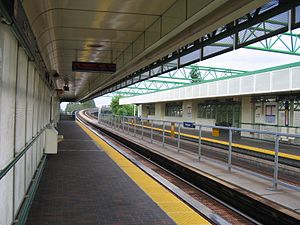
Royal Oak station (SkyTrain)
Metro Vancouver SkyTrain station
Distance: Approx. 2305 meters
Latitude and longitude: 49.220004,-122.988381
Royal Oak is an elevated station on the Expo Line of Metro Vancouver's SkyTrain rapid transit system. The station is located at the intersection of Beresford Street and Royal Oak Avenue in Burnaby, British Columbia, a short walk south of Kingsway and Imperial Avenue.
Burnaby-Edmonds
Provincial electoral district in British Columbia, Canada
Distance: Approx. 1088 meters
Latitude and longitude: 49.206,-122.977
Burnaby-Edmonds is a former provincial electoral district for the Legislative Assembly of British Columbia, Canada in use from 1966 to 2024. Under the 2021 redistribution that took effect for the 2024 election. the riding was divided between the new districts of Burnaby South-Metrotown (taking in most portions west of Griffiths Drive), and Burnaby-New Westminster (taking in portions east of it, including the Edmonds community).

Edmonds station (SkyTrain)
Metro Vancouver SkyTrain station
Distance: Approx. 2523 meters
Latitude and longitude: 49.212054,-122.959226
Edmonds is an at-grade station on the Expo Line of Metro Vancouver's SkyTrain rapid transit system. The station is located southwest of the intersection of Griffiths Drive and 18th Avenue, near Edmonds Street, south of Kingsway in the Edmonds area of Burnaby, British Columbia. SkyTrain's maintenance and storage facility serving both the Expo and Millennium lines is one block east of this station, linked to and from the main guideway by multiple switch tracks.
22nd Street station (SkyTrain)
Metro Vancouver SkyTrain station
Distance: Approx. 2819 meters
Latitude and longitude: 49.2,-122.94916667
22nd Street is an elevated station on the Expo Line of Metro Vancouver's SkyTrain rapid transit system. It is located on 7th Avenue and 22nd Street in the Connaught Heights neighbourhood of New Westminster, British Columbia, Canada. Due to its proximity to the Queensborough interchange, where the Queensborough Bridge meets with Stewardson and Marine Ways, the station serves as a hub for regional bus routes.

Burnaby South Secondary School
High school in Burnaby, British Columbia, Canada
Distance: Approx. 1881 meters
Latitude and longitude: 49.21611111,-122.98527778
Burnaby South Secondary is a public high school in Burnaby, British Columbia, and it serves the South Slope, Burnaby neighbourhood, and Southern Burnaby. It is one of the eight high schools within School District 41 Burnaby, and it currently contains approximately 1700 students. The campus is shared with the secondary school for BC School for the Deaf.

CNR Bridge
Bridge in Burnaby-Richmond
Distance: Approx. 1825 meters
Latitude and longitude: 49.182903,-122.988113
Opened in 1931, the Canadian National Railway (CNR) steel truss swing span railway bridge over the north arm of the Fraser River in Metro Vancouver links Burnaby with Richmond and the south arm Vancouver Fraser Port Authority facilities on Lulu Island. The Canadian Northern Railway (CNoR) had planned to lay track from the north end of the New Westminster Bridge and cross the Fraser at the 1931 location. However, when the CNoR opened the Lulu Island branch line in 1917, it connected with the British Columbia Electric Railway (BCER) Queensborough terminus.

CJVB
Fairchild Radio station in Vancouver
Distance: Approx. 2609 meters
Latitude and longitude: 49.19294444,-123.02241667
CJVB (1470 kHz) is a radio station in Vancouver, British Columbia, Canada, which broadcasts multilingual programming. Owned by the Fairchild Group, the station with a power of 50,000 watts, using two different directional patterns for daytime and nighttime operation. CJVB's studios and transmitter are located in Richmond.

Dominion Herbal College
Distance: Approx. 359 meters
Latitude and longitude: 49.2017,-122.9846
Dominion Herbal College is North America's oldest school of herbal medicine founded in 1926 in British Columbia, Canada by Dr. Herbert Nowell. Dominion Herbal College is a post-secondary institution accredited by the Private Career Training Institutions Agency (PCTIA) offering online and distance education programs.
British Columbia School for the Deaf
Distance: Approx. 1881 meters
Latitude and longitude: 49.21611111,-122.98527778
The British Columbia School for the Deaf is a provincial school in Burnaby, British Columbia with day programs serving deaf and hard-of-hearing students. The school teaches secondary students. It serves around 50 students and shares a campus with Burnaby South Secondary School for hearing students.

Big Bend, Burnaby
Neighourhood in Burnaby, British Columbia
Distance: Approx. 663 meters
Latitude and longitude: 49.198,-122.979
Big Bend is the southernmost neighbourhood in Burnaby, British Columbia, Canada, located on the watershed of the Fraser River. The neighbourhood owes its name to the large bend that the river forms on its North Arm. Big Bend comprises all of Burnaby south of Marine Drive.
South Slope, Burnaby
Neighourhood in Burnaby, British Columbia
Distance: Approx. 2026 meters
Latitude and longitude: 49.215,-123.002
South Slope, sometimes referred to as Southern Burnaby, is a mainly single-family neighborhood in Burnaby in British Columbia, Canada, just southeast of Metrotown. It borders Suncrest, an all single-family home neighbourhood to the west, and goes as far east as Edmonds. Although the northern boundary of South Slope is Rumble Street, many residents north of the street consider themselves living in South Slope, including South Slope Elementary, and Burnaby South Secondary School.
Weather in this IP's area
broken clouds
4 Celsius
-1 Celsius
2 Celsius
4 Celsius
1010 hPa
85 %
1010 hPa
1007 hPa
10000 meters
6.69 m/s
190 degree
75 %