104.244.191.154 - IP Lookup: Free IP Address Lookup, Postal Code Lookup, IP Location Lookup, IP ASN, Public IP
Country:
 Canada
Region:
City:
Location:
Time Zone:
Postal Code:
ISP:
ASN:
language:
User-Agent:
Proxy IP:
Blacklist:
IP information under different IP Channel
ip-api
Country
Region
City
ASN
Time Zone
ISP
Blacklist
Proxy
Latitude
Longitude
Postal
Route
db-ip
Country
Region
City
ASN
Time Zone
ISP
Blacklist
Proxy
Latitude
Longitude
Postal
Route
IPinfo
Country
Region
City
ASN
Time Zone
ISP
Blacklist
Proxy
Latitude
Longitude
Postal
Route
IP2Location
104.244.191.154Country
caRegion
british columbia
City
surrey
Time Zone
America/Vancouver
ISP
Language
User-Agent
Latitude
Longitude
Postal
ipdata
Country
Region
City
ASN
Time Zone
ISP
Blacklist
Proxy
Latitude
Longitude
Postal
Route
Popular places and events near this IP address
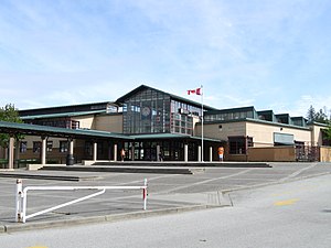
Sullivan Heights Secondary
High school in Surrey, British Columbia, Canada
Distance: Approx. 1150 meters
Latitude and longitude: 49.1164,-122.8218
Sullivan Heights Secondary is a high school located in Surrey, British Columbia, Canada. Sullivan Heights opened on October 24, 2000, with a student population of over 1000 students (grades 8 through 10), with grade 11 being added in the 2001–02 school year, and grade 12 being added in the 2002–03 school year. As of 2024–25 Sullivan Heights has 1970 students (in grades 8 through 12), and over 100 staff members.

Surrey/King George Airpark
Airport in Surrey, British Columbia
Distance: Approx. 1453 meters
Latitude and longitude: 49.09333333,-122.82277778
Surrey/King George Airpark (TC LID: CSK8) was located 1.7 nautical miles (3.1 km; 2.0 mi) southwest of Surrey, British Columbia, Canada. NAV Canada announced in a NOTAM (Notice to Airmen) on September 30, 2020, that this airpark is permanently closed.
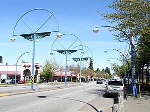
Newton, Surrey
Town centre of Surrey in British Columbia, Canada
Distance: Approx. 3229 meters
Latitude and longitude: 49.1333,-122.8413
Newton is a town centre of the city in Surrey, British Columbia. It is the location for the previous Surrey City Hall and Courthouse, two local Surrey Public Library branches, and a Kwantlen Polytechnic University campus. The studios of radio station Red FM are also located here.

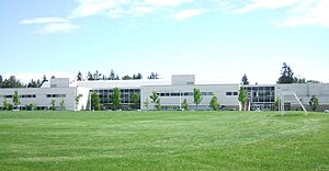
Frank Hurt Secondary School
Public high school in Surrey, British Columbia, Canada
Distance: Approx. 4094 meters
Latitude and longitude: 49.1423,-122.8366
Frank Hurt Secondary School is a public high school in the East Newton area of Surrey, British Columbia, Canada. It is part of the provincial School District 36 Surrey.
Tamanawis Secondary School
High school in Surrey, British Columbia, Canada
Distance: Approx. 3823 meters
Latitude and longitude: 49.1222,-122.8716
Tamanawis Secondary is a public secondary school in Surrey, British Columbia. It is a part of School District 36. The school provides many choices regarding subjects for its students.
Princess Margaret Secondary School (Surrey, British Columbia)
High school in Surrey, British Columbia, Canada
Distance: Approx. 4100 meters
Latitude and longitude: 49.1318,-122.8657
Princess Margaret Secondary is a public high school in Surrey, British Columbia and is part of School District 36 Surrey. The school is notable in Surrey for its sports programs. The goals of Princess Margaret Secondary include increasing reading comprehension and increasing numeracy skills in Grade 8 students.
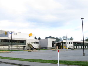
Newton Exchange
Distance: Approx. 3258 meters
Latitude and longitude: 49.13333333,-122.84222222
Newton Exchange is a bus loop located in the central Newton area of Surrey, British Columbia, Canada. As part of the TransLink system, it serves Newton with routes to Surrey City Centre, North Delta, Richmond, Langley City and White Rock, which provide connections to several SkyTrain stations for travel towards Vancouver.

Serpentine River (British Columbia)
Distance: Approx. 3161 meters
Latitude and longitude: 49.08305556,-122.85
The Serpentine River's headwaters are in North Surrey, British Columbia. The river winds its way to its mouth at Mud Bay, off the Strait of Georgia and is extensively irrigated. It has a watershed area of 116 km2 and a total length of 35 km.

Panorama Ridge Secondary School
High school in Surrey, British Columbia, Canada
Distance: Approx. 2562 meters
Latitude and longitude: 49.1182,-122.8552
Panorama Ridge Secondary is a public high school in Surrey, British Columbia, Canada and is part of School District 36 Surrey. It has a French immersion program for students in grades 8-12 and approximately 20% of the school's students are enrolled in that program. The school's website publishes notices in both English and Punjabi.

CISF-FM
Community radio station in Surrey, British Columbia
Distance: Approx. 2085 meters
Latitude and longitude: 49.1047,-122.7966
CISF-FM is an English-language radio station which broadcasts a combined adult contemporary/community radio format on the frequency of 107.7 MHz in Surrey, British Columbia, Canada. The new station is based in the Surrey town centre of Cloverdale and is owned by South Fraser Broadcasting Inc. (a different company from the similarly named South Fraser Broadcasting which once owned CISL and CKZZ-FM).

South Surrey Park and Ride
Distance: Approx. 3798 meters
Latitude and longitude: 49.07222222,-122.8225
The South Surrey Park and Ride is a bus loop and park and ride facility serving the South Surrey area. As part of the TransLink system, it is used by five routes serving South Surrey and White Rock, including towards Vancouver via Bridgeport station in Richmond as well as to Newton and Surrey City Centre.

Serpentine Wildlife Management Area
Wildlife Management Area in British Columbia, Canada
Distance: Approx. 2339 meters
Latitude and longitude: 49.08555556,-122.82
The Serpentine Wildlife Management Area is a small wildlife management area located on the south coast of British Columbia in Surrey. It contains many kilometers of walking trail and viewing towers to enjoy the nature and observe the many species found in the area. Although the boundaries have changed over the years, the Government of British Columbia still manages the land to ensure it meets the currents goals that were set in place to protect the local and endangered species that inhabit the area as well as monitoring the effects of climate change.
Weather in this IP's area
overcast clouds
2 Celsius
-1 Celsius
1 Celsius
4 Celsius
1011 hPa
92 %
1011 hPa
1010 hPa
273 meters
3.09 m/s
190 degree
100 %